1990s Maps of Caroline County, Maryland
Explore 6 historic maps of Caroline County from the 1990s. These maps offer a rare glimpse into what life looked like during the 1990s — showing old roads, neighborhoods, homes, and landmarks that have changed or disappeared over time.
Whether you're researching your family's past, planning a metal detecting trip, or studying how Caroline County's landscape evolved across the 1990s, these high-resolution maps are a powerful tool for exploring the history of this region.
- Focus on a specific era: All maps on this page are from the 1990s, giving you a focused view of this time period.
- See what’s changed: Compare century-old streets, trails, and buildings to today's modern landscape using overlays and satellite layers.
- Research with precision: Use these maps for genealogy, historical research, land use analysis, or educational projects.
- View, download, or print: Maps are fully viewable online in high resolution, and can be downloaded or printed for your own records.
Start exploring Caroline County's history through authentic maps from the 1990s. This is your window into the past.
Caroline County, MD maps
(6)- 1992 Map of Seaford West
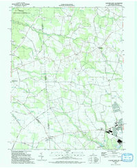 1992 Seaford West1992 Print · USGSThe Delaware-Maryland borderlands come into focus in the early nineties, showing the rural reaches of Sussex County as it meets Federalsburg. Researchers can locate rural landmarks like New Liberty Ch, the crossroads at Atlanta, and old milling sites near Craigs Mill.
 - 1993 Map of Hickman
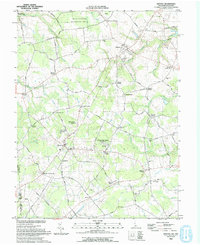
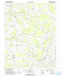
 1993 Hickman1993 Print · USGSThe rural borderlands of Delaware and Maryland come to life in this early 1990s survey of the Marshyhope Creek drainage. Researchers can locate family landmarks such as the Ledenham School, Bethel Ch, and the old rail line passing through Hickman.
 - 1993 Map of Marydel
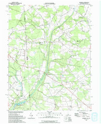
 1993 Marydel1993 Print · USGSThe Delaware and Maryland borderlands come into focus in the early nineties, revealing a landscape defined by drainage ditches and rural crossroads. Researchers can trace historic local institutions like Thomas Chapel, the legacy of Choptank Mills, and family-named landmarks including Lords Corner and Stantons Cross Road.
 - 1993 Map of Sudlersville
 1993 Sudlersville1993 Print · USGSQueen Anne's County is seen here in the early nineties as a network of crossroads hamlets and family farmsteads along the Delaware line. Genealogists can trace property near Sudlersville and Barclay, or locate old landmarks like Holdens Ch and Unicorn Mill Pond.
 - 1993 Map of Kenton
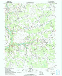
 1993 Kenton1993 Print · USGSWestern Kent County in the early nineties remains a landscape of historic crossroads and small-scale agriculture. Genealogists and local historians can trace family-named intersections such as Fords Corner and Dinahs Corner or locate rural landmarks like Masseys Millpond and Bryn Zion Cem.
 - 1993 Map of Burrsville
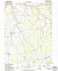
 1993 Burrsville1993 Print · USGSThe Maryland-Delaware border region in the early nineties is a dense network of agricultural hamlets and named crossroads. Genealogists can trace family names through landmarks like Schultie Crossroads, Manship Ch, and Garey Mill Pond.
End of results
Showing maps 1-6 of 6
Top cities of Caroline County
- Denton historical maps
- Federalsburg historical maps
- Greensboro historical maps
- Ridgely historical maps
- Preston historical maps
- Goldsboro historical maps
See more
Frequently asked questions
- What are the different types of historical maps available for Caroline County?
- What is the oldest map of Caroline County?
- Where can I purchase historical maps of Caroline County for my home or office?
- Where can I download high-res historical maps of Caroline County?
- Are there historical topographic maps available for Caroline County?
- Is there historical aerial imagery available for Caroline County?
- Where are historical maps of Caroline County sourced from?