Old Maps of Frederick County, Maryland for Hiking & Exploration
Hike through history with 182 historic maps of Frederick County. Explore old trails, ghost towns, and forgotten backroads — perfect for outdoor adventurers and local explorers.
- Rediscover forgotten places: Map out old mining camps, roads, and footpaths that no longer exist on modern maps.
- Layer with modern tools: Combine with LiDAR or satellite views to plan hikes through historical terrain.
- Made for exploration: Popular among hikers, overlanders, and local history lovers.
Use these maps to find adventure and explore the hidden past of Frederick County.
Frederick County, MD maps
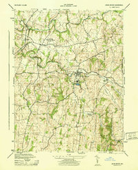
(182)- 1884 Map of Harpers Ferry
 1884 Harpers Ferry1884 Print · USGSThe confluence of the Potomac and Shenandoah rivers is captured in the mid-1880s, documenting a landscape of strategic gaps and vital transit corridors. Researchers can trace the path of the Chesapeake and Ohio Canal and locate historic river crossings like Conrad Ferry and Castleman Ferry.
 - 1891 Map of Harpers Ferry
 1891 Harpers Ferry1891 Print · USGSThe tri-state borderlands of the Potomac and Shenandoah valleys were a vital hub of transport and trade in the late 1800s. Researchers can trace historic river crossings like Castlemans Ferry, follow the route of the Chesapeake and Ohio Canal, or locate family-named settlements like Oatlands and Taylorstown.
 - 1893 Map of Frederick
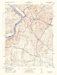
 1893 Frederick1893 Print · USGSMaryland's Piedmont region at the end of the nineteenth century reveals a landscape defined by the Potomac River and the rise of rail transit. Researchers can trace the path of the Chesapeake and Ohio Canal or locate local hubs like Poolesville and Buckeystown.
 - 1893 Map of Harpers Ferry, 1898 Print
 1893 Harpers Ferry1898 Print · USGSThe tri-state region of the Potomac and Shenandoah valleys is captured here in the late nineteenth century, showing a landscape defined by water and rail. Trace the historic Chesapeake and Ohio Canal or locate local landmarks like Snyder Mills and Harpers Ferry.7 unique versions available
 - 1894 Map of Frederick
 1894 Frederick1894 Print · USGSMaryland's Piedmont region in the late nineteenth century was a complex network of river crossings and railway junctions. Researchers can trace the path of the Baltimore & Ohio R. R. past Sugar Loaf Mtn. and locate historic river sites like Nolands Ferry.5 unique versions available
 - 1908 Map of Middletown
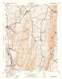
 1908 Middletown1908 Print · USGSThe Potomac River valley in the early twentieth century shows a landscape defined by the convergence of major rail lines and the historic Chesapeake and Ohio Canal. Genealogists and historians can trace the foundations of Eakles Mills, Burkittsville, and Washington Junction.
 - 1908 Map of Seneca
 1908 Seneca1908 Print · USGSThe Potomac River valley at the turn of the century shows a vital landscape of canal commerce and emerging rail lines. Genealogists and historians can trace family-named sites across the Maryland-Virginia border, from Poolesville to river crossings at Whites Ferry and Edwards Ferry.7 unique versions available
 - 1908 Map of Ijamsville, 1921 Print
 1908 Ijamsville1921 Print · USGSFrederick and its surrounding valley are captured here just after the turn of the century, showing a landscape defined by historic turnpikes and the winding Monocacy River. Genealogists and historians can trace defunct schoolhouses, early turnpike toll gates like Fountain Rock T.G., and family landmarks near Sugarloaf Mtn.
 - 1909 Map of Mount Airy
 1909 Mount Airy1909 Print · USGSCentral Maryland's Piedmont region is captured here during the height of the steam-rail era, centered on the strategic crossing at Mount Airy. Genealogists and historians can trace old property locations near Shipleys Mill, the winding Gary Turnpike, and rural settlements like Winfield and Libertytown.7 unique versions available
 - 1909 Map of Ijamsville
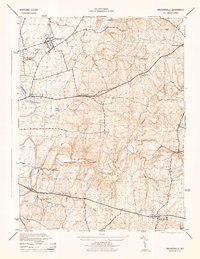
 1909 Ijamsville1909 Print · USGSFrederick County and parts of Montgomery County are documented here during an era of significant rail and turnpike expansion. Genealogists and historians can locate early post offices and stations such as Araby P O, Ijamsville, and the Almshouse near Frederick.9 unique versions available
 - 1909 Map of Hagerstown
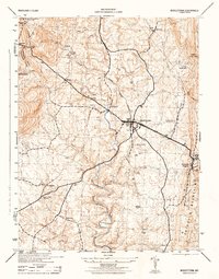
 1909 Hagerstown1909 Print · USGSHagerstown and the Antietam valley appear here during the height of the steam rail era, shortly after the turn of the century. Genealogists and historians can locate family homesteads near landmarks like St James Church, Smoketown School, and the Hagerstown and Boonsboro Ry.
 - 1910 Map of Antietam
 1910 Antietam1910 Print · USGSMaryland's borderlands and the Potomac River valley are captured here in the early twentieth century. Genealogists can locate family landmarks like Garretts Mill, trace the Chesapeake and Ohio Canal, or find historic sites including Dunkard Church.6 unique versions available
 - 1911 Map of Taneytown
 1911 Taneytown1911 Print · USGSCarroll County and the Maryland-Pennsylvania borderlands are captured here just after the turn of the century, showing a network of rail-linked towns and water-powered mills. Trace local history through Taneytown, Union Mills, and Pipe Creek Church, or find early school sites like Centennial Hall School.6 unique versions available
 - 1911 Map of Emmitsburg
 1911 Emmitsburg1911 Print · USGSMaryland's northern borderlands and the Catoctin mountains thrived in the early twentieth century as a hub for institutions, railroads, and milling. Genealogists and historians can locate family homes and old crossroads near St Josephs Academy, Sabillasville, and the Western Maryland RR.6 unique versions available
 - 1912 Map of Hagerstown
 1912 Hagerstown1912 Print · USGSMaryland's Cumberland Valley flourished as a rail and milling corridor during the early twentieth century. Genealogists can trace family names across dozens of rural landmarks like Strites Mill, Hallowell Church, and the Paradise School.9 unique versions available
 - 1942 Map of Hagerstown
 1942 Hagerstown1942 Print · USGSThe Cumberland Valley and Potomac corridor are captured here at the height of the Second World War rail-and-river era. Genealogists and historians can trace the industrial landscape of Richmond Furnace, the route of the Chesapeake and Ohio Canal, and the grounds of Camp Ritchie.
 - 1942 Map of Frederick
 1942 Frederick1942 Print · USGSMid-century Maryland's central corridor is centered on Frederick as it appeared before the modern interstate system. Researchers can trace the routes of the B & O Canal, locate the Montevue Almshouse, and see the intersection of the Northern Central RR with early turnpikes.
 - 1942 Map of Gettysburg, 1944 Print
 1942 Gettysburg1944 Print · USGSGettysburg and its surrounding borderlands are shown in great detail during the early 1940s, capturing the region's dense network of rural schools and mills. Genealogists can trace family-named landmarks such as Galt Kump PO, Hafers Mill, and Philips Delight Sch.
 - 1943 Map of Emmitsburg
 1943 Emmitsburg1943 Print · USGSMaryland's northern border and the Frederick Valley appear during the early 1940s, where the Catoctin range meets the Monocacy plain. Genealogists can trace family names at Hoovers Mill, locate historic institutions like Mount St Marys College, or follow the Western Maryland RR.4 unique versions available
 - 1943 Map of Hagerstown
 1943 Hagerstown1943 Print · USGSThe Cumberland Valley was a critical wartime logistics hub in the 1940s, teeming with rail traffic and new military installations. Genealogists and historians can trace the Chesapeake and Ohio Canal or locate local landmarks like Richmond Furnace and Camp Ritchie.
 - 1944 Map of Middletown
 1944 Middletown1944 Print · USGSMaryland's Middletown Valley during the mid-forties reveals a rural landscape of crossroads hamlets and prominent ridge-line monuments. Researchers can locate family-named settlements like Zittlestown and Frostown or trace mountain landmarks from Fox Gap to the Catoctin Mountain range.2 unique versions available
 - 1944 Map of Walkersville
 1944 Walkersville1944 Print · USGSFrederick County at the height of the Second World War shows a rural landscape of limestone quarries, rail corridors, and small crossroads hamlets. Genealogists can trace family footprints through Walkersville, Libertytown, and New Market, or locate industrial sites like the Lime Kiln and Old Quarry.2 unique versions available
 - 1944 Map of Poolesville
 1944 Poolesville1944 Print · USGSMaryland's agricultural heartland and the Potomac riverfront are detailed here during the mid-1940s, just as the rural landscape began its modern shift. Researchers can trace the path of the Chesapeake and Ohio Canal and locate old crossroads at Beallsville, Poolesville, and Jerusalem.2 unique versions available
 - 1944 Map of Keddysville
 1944 Keddysville1944 Print · USGSMaryland's Civil War landscape and rural hubs appear in transition during the mid-forties. Genealogists and historians can trace family locations near Antietam National Cemetery, old stops along the Baltimore and Ohio, or the path of the Chesapeake and Ohio Canal.2 unique versions available
 - 1944 Map of Union Bridge
 1944 Union Bridge1944 Print · USGSMaryland's agricultural and industrial borderlands thrive during the mid-forties at the junction of two major rail lines. Genealogists and historians can trace the local economy through the Lehigh Portland Cement Company and historic sites like Mc Kinstrys Mill and Keymar.
Showing maps 1-25 of 182
Top cities of Frederick County
- Frederick historical maps
- Ballenger Creek historical maps
- Urbana historical maps
- Linganore historical maps
- Brunswick historical maps
- Thurmont historical maps
See more
Frequently asked questions
- What are the different types of historical maps available for Frederick County?
- What is the oldest map of Frederick County?
- Where can I purchase historical maps of Frederick County for my home or office?
- Where can I download high-res historical maps of Frederick County?
- Are there historical topographic maps available for Frederick County?
- Is there historical aerial imagery available for Frederick County?
- Where are historical maps of Frederick County sourced from?