1950s Maps of Frederick County, Maryland
Explore 26 historic maps of Frederick County from the 1950s. These maps offer a rare glimpse into what life looked like during the 1950s — showing old roads, neighborhoods, homes, and landmarks that have changed or disappeared over time.
Whether you're researching your family's past, planning a metal detecting trip, or studying how Frederick County's landscape evolved across the 1950s, these high-resolution maps are a powerful tool for exploring the history of this region.
- Focus on a specific era: All maps on this page are from the 1950s, giving you a focused view of this time period.
- See what’s changed: Compare century-old streets, trails, and buildings to today's modern landscape using overlays and satellite layers.
- Research with precision: Use these maps for genealogy, historical research, land use analysis, or educational projects.
- View, download, or print: Maps are fully viewable online in high resolution, and can be downloaded or printed for your own records.
Start exploring Frederick County's history through authentic maps from the 1950s. This is your window into the past.
Frederick County, MD maps
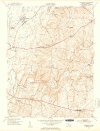
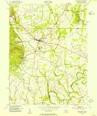
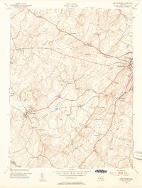
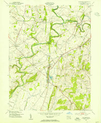
(26)- 1950 Map of Libertytown
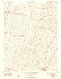 1950 Libertytown1950 Print · USGSMaryland's Piedmont region is captured here at mid-century, showing the rural landscapes of Frederick and Carroll Counties. Genealogists can locate family-named landmarks and institutions like Ridge Sch No 4, the Lime Mill, and settlements including Dorceytown and Woodville.2 unique versions available
 - 1950 Map of Winfield
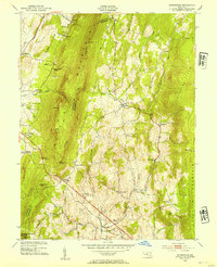
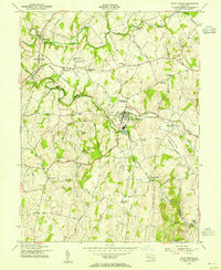
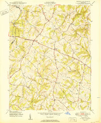 1950 Winfield1950 Print · USGSMid-century Carroll County life is centered here on the prominence of Parrs Ridge and a network of rural crossroads. Genealogists and local historians can trace family locations near Taylorsville, Winfield, and the Woodbine Sch.5 unique versions available
 - 1950 Map of Damascus
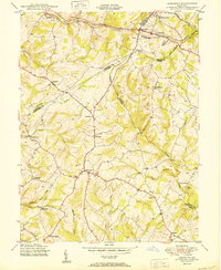 1950 Damascus1950 Print · USGSMid-century Maryland rural life is captured here at the intersection of four counties as agricultural communities thrived. Genealogists can trace family lands near Damascus or locate early settlements like Bartholows and Browningsville along the Baltimore and Ohio RR.2 unique versions available
 - 1952 Map of Buckeystown, 1953 Print
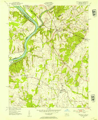
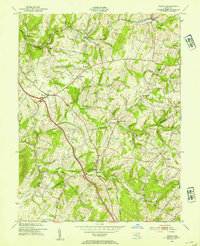
 1952 Buckeystown1953 Print · USGSFrederick County in the early fifties remains a landscape of rail-fed villages and river bottom industry. Genealogists and local historians can trace the foundations of Carrollton Manor, find the Brick Kilns at Lime Kiln, or locate Michaels Mill along the Monocacy.8 unique versions available
 - 1952 Map of Poolesville, 1954 Print
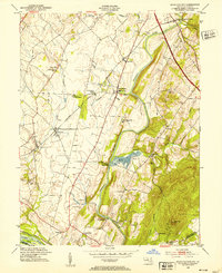
 1952 Poolesville1954 Print · USGSMontgomery County was still primarily a landscape of rail-stops and river-crossings in the early fifties. Local historians can trace the intersection of the Baltimore and Ohio railroad with rural life at Dickerson and Barnesville.3 unique versions available
 - 1953 Map of Point of Rocks
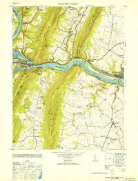
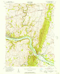
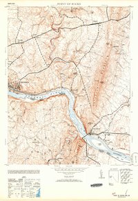 1953 Point of Rocks1953 Print · USGSThe Potomac River borderlands thrive in the early 1950s as a vital corridor for the Baltimore and Ohio railroad and historic canal. Researchers can pinpoint long-standing community centers like the Lander P O, St Marks Church, and Lewis Mill.2 unique versions available
 - 1953 Map of Walkersville
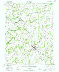
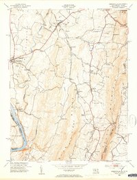
 1953 Walkersville1953 Print · USGSMid-century Frederick County comes to life in this survey of the agrarian lands around the Monocacy River and the growing town of Walkersville. Genealogists can trace family footprints at Glade Cem, Silver Hill Ch, and old crossroads like McKaig or Daysville.8 unique versions available
 - 1953 Map of Taneytown
 1953 Taneytown1953 Print · USGSThe Maryland-Pennsylvania borderlands are captured here in the mid-1950s, centered on the growing crossroads of Taneytown. Researchers can trace old property lines and rural life through landmarks like the Hoffman Orphanage, Mairs Mill, and the Penn Central rail corridor.5 unique versions available
 - 1953 Map of Harpers Ferry
 1953 Harpers Ferry1953 Print · USGSHarpers Ferry sits at the heart of this mid-century survey where the Potomac and Shenandoah rivers meet during a period of transition for the region's rail and canal heritage. Trace the grounds of Storer College and locate rural landmarks like Garretts Mill and the C and O Canal.
 - 1953 Map of Emmitsburg, 1954 Print
 1953 Emmitsburg1954 Print · USGSThe Pennsylvania-Maryland border country comes into focus in the early 1950s, showing the historic Mason and Dixon Line and the academic institutions of Emmitsburg. Genealogists and historians can trace local landmarks like St Josephs College, St Josephs Cemetery, and the river junction at Motters.5 unique versions available
 - 1953 Map of Myersville, 1954 Print
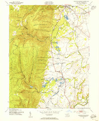
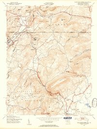
 1953 Myersville1954 Print · USGSThe Frederick and Washington County line follows the crest of the Blue Ridge in the early fifties, where the Appalachian Trail winds past Annapolis Rock. Genealogists and historians can locate rural homesteads near Wolfsville Crossing, St Marks Ch, and Jerusalem.6 unique versions available
 - 1953 Map of Frederick, 1954 Print
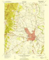 1953 Frederick1954 Print · USGSMaryland's interior growth is on full display here during the early fifties as the city of Frederick pushes toward Catoctin Mountain. Researchers can trace the layout of the U S Military Reservation at Camp Detrick and locate local landmarks like Hood College and Mt Olivet Cemetery.8 unique versions available
 - 1953 Map of Middletown, 1954 Print
 1953 Middletown1954 Print · USGSMaryland's Middletown Valley is shown here in the early fifties, caught between the parallel ridges of South and Catoctin Mountains. Genealogists and hikers can trace the Appalachian Trail past the Reno Monument or locate family roots near Burkittsville and Pleasant View Ch.6 unique versions available
 - 1953 Map of New Windsor, 1954 Print
 1953 New Windsor1954 Print · USGSCarroll County was a thriving network of mill towns and educational hubs in the mid-fifties, centered on the Western Maryland railroad. Researchers can trace family-named landmarks like Bailes Mill, Wakefield Mill, and the historic Western Maryland College.6 unique versions available
 - 1953 Map of Urbana, 1954 Print
 1953 Urbana1954 Print · USGSMid-century Frederick and Montgomery Counties are captured here just as the modern highway begins to bypass rural crossroads. Genealogists and local historians can trace the foundations of Urbana and Monrovia or locate the German Brethren Ch and Ebenezer Sch.6 unique versions available
 - 1953 Map of Keedysville, 1954 Print
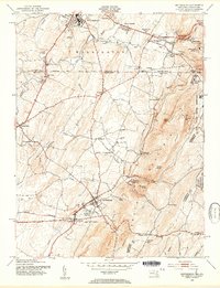
 1953 Keedysville1954 Print · USGSThe hallowed ground of the Antietam Battlefield and the ridges of South Mountain are captured here in the early fifties. Local historians can trace the Appalachian Trail, the Baltimore and Ohio rail line, and landmarks like Burnside Bridge.5 unique versions available
 - 1953 Map of Catoctin Furnace, 1955 Print
 1953 Catoctin Furnace1955 Print · USGSFrederick County's mountain-and-valley landscape is captured here during the post-war era, showing the transition from mountain recreation to valley industry. Researchers can trace the Western Maryland rail line through Catoctin Furnace and locate local landmarks like the Lewistown State Fish Hatchery.7 unique versions available
 - 1953 Map of Woodsboro, 1955 Print
 1953 Woodsboro1955 Print · USGSMid-century Frederick County, Maryland, is captured here during a time of active rail transport and river-valley farming. Genealogists and researchers can locate family landmarks like Rocky Hill Ch, the Fish Hatchery, and the old rail stop at Rocky Ridge.6 unique versions available
 - 1953 Map of Union Bridge, 1955 Print
 1953 Union Bridge1955 Print · USGSUnion Bridge and the Carroll-Frederick county border thrive in the early 1950s as a vital railroad junction. Researchers can trace the legacy of early industry through named sites like McKinstrys Mill, the local Copper Mine, and Bowens Chapel.3 unique versions available
 - 1953 Map of Blue Ridge Summit, 1955 Print
 1953 Blue Ridge Summit1955 Print · USGSMaryland and Pennsylvania meet along the mountain crests in the early fifties, where the railroad and state line define local life. Genealogists and hikers can trace the Western Maryland tracks past Wesley Chapel, Charmian, and the Victor Cullen State Hospital.7 unique versions available
 - 1953 Map of Smithsburg, 1955 Print
 1953 Smithsburg1955 Print · USGSThe Maryland-Pennsylvania borderlands come alive in the early 1950s, showing the intersection of ridge-top recreation and valley agriculture. Researchers can trace the Mason and Dixon Line, locate historic sites like Pen Mar Park, and follow the Western Maryland rail line.5 unique versions available
 - 1954 Map of Baltimore
 1954 Baltimore1954 Print · USGSThe Mid-Atlantic region in the early fifties shows a landscape of growing suburban centers and heavy rail corridors. Trace mid-century transit networks and military landmarks from the Aberdeen Proving Ground to the Gettysburg National Military Park.
 - 1955 Map of Point Of Rocks, 1956 Print
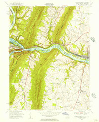
 1955 Point Of Rocks1956 Print · USGSThe river gap at Point of Rocks was a vital Maryland transportation nexus in the mid-fifties, where the rail and canal era met the river. Researchers can trace historic church sites like St Marks Ch and small hubs like Slabtown or Bells Mill.2 unique versions available
 - 1955 Map of Harpers Ferry, 1956 Print
 1955 Harpers Ferry1956 Print · USGSThe tri-state junction of West Virginia, Maryland, and Virginia is captured here during the mid-fifties as modern preservation began to take shape. Researchers can trace the Appalachian Trail, the historic Chesapeake and Ohio Canal, and local landmarks like Garretts Mill.2 unique versions available
 - 1956 Map of Baltimore
 1956 Baltimore1956 Print · USGSMid-century Maryland and Pennsylvania are captured here during a period of massive suburban and military growth across the Chesapeake region. Genealogists and historians can trace the rail corridors of the Baltimore & Ohio RR and locate landmarks like Fort McHenry or the Aberdeen Proving Ground.
Showing maps 1-25 of 26
Top cities of Frederick County
- Frederick historical maps
- Ballenger Creek historical maps
- Urbana historical maps
- Linganore historical maps
- Brunswick historical maps
- Thurmont historical maps
See more
Frequently asked questions
- What are the different types of historical maps available for Frederick County?
- What is the oldest map of Frederick County?
- Where can I purchase historical maps of Frederick County for my home or office?
- Where can I download high-res historical maps of Frederick County?
- Are there historical topographic maps available for Frederick County?
- Is there historical aerial imagery available for Frederick County?
- Where are historical maps of Frederick County sourced from?