1950s Maps of Saint Mary's County, Maryland
Explore 11 historic maps of Saint Mary's County from the 1950s. These maps offer a rare glimpse into what life looked like during the 1950s — showing old roads, neighborhoods, homes, and landmarks that have changed or disappeared over time.
Whether you're researching your family's past, planning a metal detecting trip, or studying how Saint Mary's County's landscape evolved across the 1950s, these high-resolution maps are a powerful tool for exploring the history of this region.
- Focus on a specific era: All maps on this page are from the 1950s, giving you a focused view of this time period.
- See what’s changed: Compare century-old streets, trails, and buildings to today's modern landscape using overlays and satellite layers.
- Research with precision: Use these maps for genealogy, historical research, land use analysis, or educational projects.
- View, download, or print: Maps are fully viewable online in high resolution, and can be downloaded or printed for your own records.
Start exploring Saint Mary's County's history through authentic maps from the 1950s. This is your window into the past.
Saint Mary's County, MD maps
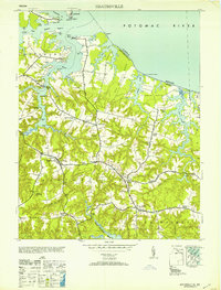
(11)- 1950 Map of Leonardtown, 1964 Print
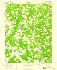
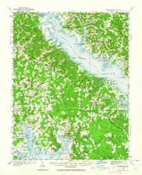 1950 Leonardtown1964 Print · USGSMid-century Southern Maryland comes alive on this peninsula bounded by the Patuxent and Potomac estuaries. Genealogists and historians can trace family-named points and rural infrastructure through landmarks like St Andrews Ch, Williams Wharf, and Broomes Island.
 - 1953 Map of Sunnybank
 1953 Sunnybank1953 Print · USGSNorthumberland County in the early fifties shows a vibrant Tidewater landscape of isolated peninsulas and waterfront commerce. Local researchers can locate crossroads stores like Burgess Store, rural landmarks such as Grays School, and the Fairfields Ch and Cem.
 - 1953 Map of Piney Point
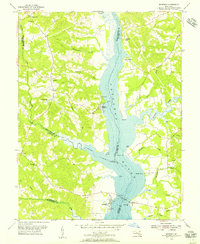
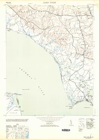 1953 Piney Point1953 Print · USGSThe Potomac River shoreline comes to life in the early 1950s, showing the maritime heart of St. Mary's County. You can trace the coastal landscape from Piney Point Lighthouse to the post office at Tall Timbers and the historic St Georges Ch.2 unique versions available
 - 1953 Map of Blakiston Island
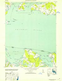 1953 Blakiston Island1953 Print · USGSThe Potomac River shoreline near St. Mary's and Westmoreland County is captured here in the early fifties, showing a landscape defined by tidewater inlets and maritime activity. Researchers can trace land tracts on Machodoc Neck or locate the Blakiston I Lighthouse and the Proving Ground near Newtown.2 unique versions available
 - 1953 Map of Heathsville
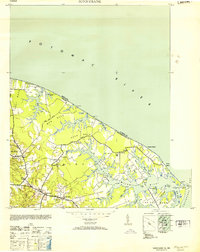
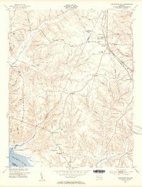
 1953 Heathsville1953 Print · USGSNorthumberland County's tidewater landscape comes to life in the mid-1940s, showing a world of river landings and crossroads churches. Genealogists and historians can trace family locations near Sissons Corner, St Stephens Ch, and old industry sites like Crabbe Mill.
 - 1953 Map of Charlotte Hall, 1954 Print
 1953 Charlotte Hall1954 Print · USGSSouthern Maryland in the early fifties maintains its rural character as tobacco fields and wooded ridges meet the Wicomico River marshes. Trace ancestral roots at John Wesley Cemetery or explore the grounds of the Charlotte Hall Military Academy and White Marsh School.5 unique versions available
 - 1953 Map of Mechanicsville, 1956 Print
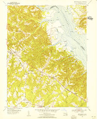 1953 Mechanicsville1956 Print · USGSSt. Mary's County in the early fifties shows a rural landscape defined by the Patuxent River and its tidal creeks. Genealogists and local historians can trace family-named points and early schools like Brent High Sch, St Joseph Sch, and the community of Mechanicsville.4 unique versions available
 - 1953 Map of Benedict, 1956 Print
 1953 Benedict1956 Print · USGSThe Patuxent River valley in the early 1950s shows a landscape of tidal creeks and riverside landings across four Maryland counties. Genealogists and local historians can trace family-named sites like Holland Cliff, Leitch Wharf, and the settlement at Aquasco.5 unique versions available
 - 1956 Map of Hughesville, 1958 Print
 1956 Hughesville1958 Print · USGSSouthern Maryland in the mid-fifties is defined by rural crossroads and the expansive Cedarville State Forest. Genealogists and historians can trace community roots through landmarks like Old Field Cem, Burnt Store, and the cluster of schools near Bryantown.4 unique versions available
 - 1957 Map of Washington, 1966 Print
 1957 Washington1966 Print · USGSThe mid-Atlantic region during the mid-fifties and early sixties reveals a landscape of growing suburbs and vital military outposts. Researchers can trace historic river towns and shorelines from Alexandria to the Hooper Islands and St Clements Island.5 unique versions available
 - 1959 Map of Richmond
 1959 Richmond1959 Print · USGSMid-century Virginia is captured here at its most vital rail and river junctions, from the capital city to the Chesapeake Bay. Genealogists and historians can trace the development of colonial settlements like Williamsburg and military landmarks including Fort Monroe and Camp Lee.
End of results
Showing maps 1-11 of 11
Top cities of Saint Mary's County
- Lexington Park historical maps
- Golden Beach historical maps
- Leonardtown historical maps
- Callaway historical maps
- Mechanicsville historical maps
- Charlotte Hall historical maps
See more
Frequently asked questions
- What are the different types of historical maps available for Saint Mary's County?
- What is the oldest map of Saint Mary's County?
- Where can I purchase historical maps of Saint Mary's County for my home or office?
- Where can I download high-res historical maps of Saint Mary's County?
- Are there historical topographic maps available for Saint Mary's County?
- Is there historical aerial imagery available for Saint Mary's County?
- Where are historical maps of Saint Mary's County sourced from?