1910s Maps of Saint Mary's County, Maryland
Explore 8 historic maps of Saint Mary's County from the 1910s. These maps offer a rare glimpse into what life looked like during the 1910s — showing old roads, neighborhoods, homes, and landmarks that have changed or disappeared over time.
Whether you're researching your family's past, planning a metal detecting trip, or studying how Saint Mary's County's landscape evolved across the 1910s, these high-resolution maps are a powerful tool for exploring the history of this region.
- Focus on a specific era: All maps on this page are from the 1910s, giving you a focused view of this time period.
- See what’s changed: Compare century-old streets, trails, and buildings to today's modern landscape using overlays and satellite layers.
- Research with precision: Use these maps for genealogy, historical research, land use analysis, or educational projects.
- View, download, or print: Maps are fully viewable online in high resolution, and can be downloaded or printed for your own records.
Start exploring Saint Mary's County's history through authentic maps from the 1910s. This is your window into the past.
Saint Mary's County, MD maps
(8)- 1910 Map of Prince Frederick
 1910 Prince Frederick1910 Print · USGSCoastal Calvert County comes alive in the early twentieth century, showing a landscape defined by the Patuxent River and the bay. Genealogists can trace old wharves and family settlements from Lower Marlboro to the Chesapeake Beach RR line.3 unique versions available
 - 1911 Map of Wicomico, 1961 Print
 1911 Wicomico1961 Print · USGSSouthern Maryland's river-dependent landscape is documented here during the early twentieth century, showing the tidewater border of Charles and St Marys counties. Genealogists can trace family-named points and wharves like Lancaster Wharf, the Laidlow Ferry, and the rail terminus at Popes Creek.
 - 1911 Map of Brandywine, 1962 Print
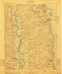
 1911 Brandywine1962 Print · USGSSouthern Maryland at the turn of the century shows a landscape of rail-connected farming towns and expansive wetlands. Researchers can trace ancestral locations near LA PLATA, the old Reform School, or country parishes like St Peters Church and Piney Church.
 - 1912 Map of Point Lookout
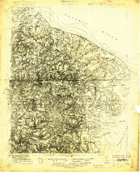
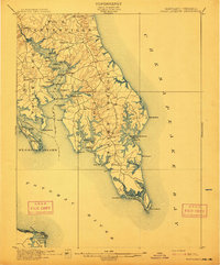 1912 Point Lookout1912 Print · USGSSouthern St. Mary's County appears here just after the turn of the century, showing a waterfront economy dependent on the river and bay. Genealogists and historians can trace family landings at Broomes Wharf and Miller Wharf or locate old settlements like St Inigoes and Great Mills.2 unique versions available
 - 1913 Map of Brandywine
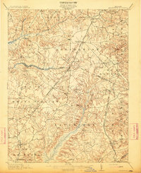 1913 Brandywine1913 Print · USGSSouthern Maryland at the turn of the century shows a landscape transitioning through early rail and rural growth. Genealogists can trace family roots through landmarks like St Peters Church, Winkler Shop School, and old stops such as Malcolm Woodville Station.3 unique versions available
 - 1914 Map of Wicomico
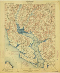 1914 Wicomico1914 Print · USGSSouthern Maryland's riverfront life is captured here during the early twentieth century, showing a landscape of tidal creeks and busy steamboat landings. Genealogists can trace family footprints near Charlotte Hall, find old crossings like Ludlow Ferry, or locate historic maritime hubs like Bushwood Wharf.4 unique versions available
 - 1917 Map of Heathsville
 1917 Heathsville1917 Print · USGSNorthumberland County's peninsulas and maritime crossroads are intricately detailed here during the late 1910s. Local researchers can trace family roots through historic landmarks like Macedonia Church, Coan Hall School, and the busy waters of the Steamboat Route at Reedville.4 unique versions available
 - 1917 Map of Ewell
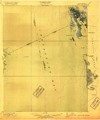 1917 Ewell1917 Print · USGSIsolated island life in the Chesapeake comes into focus during the early twentieth century. Researchers can trace the original footprints of Ewell, Rhodes Point, and Tangier, alongside maritime landmarks like the Smith Point LH and old Steamboat Routes.2 unique versions available
End of results
Showing maps 1-8 of 8
Top cities of Saint Mary's County
- Lexington Park historical maps
- Golden Beach historical maps
- Leonardtown historical maps
- Callaway historical maps
- Mechanicsville historical maps
- Charlotte Hall historical maps
See more
Frequently asked questions
- What are the different types of historical maps available for Saint Mary's County?
- What is the oldest map of Saint Mary's County?
- Where can I purchase historical maps of Saint Mary's County for my home or office?
- Where can I download high-res historical maps of Saint Mary's County?
- Are there historical topographic maps available for Saint Mary's County?
- Is there historical aerial imagery available for Saint Mary's County?
- Where are historical maps of Saint Mary's County sourced from?