1900-1909 Maps of Saint Mary's County, Maryland
Explore 9 historic maps of Saint Mary's County from 1900-1909. These maps offer a rare glimpse into what life looked like during the 1900s — showing old roads, neighborhoods, homes, and landmarks that have changed or disappeared over time.
Whether you're researching your family's past, planning a metal detecting trip, or studying how Saint Mary's County's landscape evolved across the 1900s, these high-resolution maps are a powerful tool for exploring the history of this region.
- Focus on a specific era: All maps on this page are from the 1900s, giving you a focused view of this time period.
- See what’s changed: Compare century-old streets, trails, and buildings to today's modern landscape using overlays and satellite layers.
- Research with precision: Use these maps for genealogy, historical research, land use analysis, or educational projects.
- View, download, or print: Maps are fully viewable online in high resolution, and can be downloaded or printed for your own records.
Start exploring Saint Mary's County's history through authentic maps from the 1900s. This is your window into the past.
Saint Mary's County, MD maps
(9)- 1901 Map of Drum Point
 1901 Drum Point1901 Print · USGSThe maritime heart of the lower Chesapeake Bay comes alive in this turn-of-the-century survey of the Calvert and St. Mary’s coastline. Genealogists and historians can trace old landings and light stations like Millstone Landing, Spencers Wharf, and the Drum Pt. L.H. at the mouth of the Patuxent River.
 - 1901 Map of Prince Frederick
 1901 Prince Frederick1901 Print · USGSThe Tidewater region of Maryland is captured here at the dawn of the twentieth century, when river travel and steamship wharves still defined the local economy. Researchers can locate vanished landings and ferry crossings like Magruder Ferry, Leitch Wharf, and Lower Marlboro.
 - 1901 Map of Leonardtown
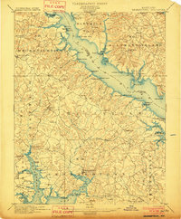 1901 Leonardtown1901 Print · USGSMaryland's tidewater country at the turn of the century is defined by its deep reliance on the river and bay. Genealogists and historians can trace the vital maritime economy through old landings and wharves like Sotterly Wharf, Abells Wharf, and Coburns Wharf.3 unique versions available
 - 1901 Map of Piney Point
 1901 Piney Point1901 Print · USGSThe Potomac River tidewater at the opening of the twentieth century was a landscape of remote landings and river-bound commerce. Researchers can trace historic ferry crossings at Mount Holly, find the L.H. at Piney Point, or locate old mill sites like Clifton Mills.5 unique versions available
 - 1902 Map of Wicomico
 1902 Wicomico1902 Print · USGSCoastal Maryland at the turn of the century shows a landscape tied to the tides and the tracks. Trace the vital waterfront economy through Ludlow Ferry and Plowdens Wharf, or follow the path of the Southern Maryland R. R. past Charlotte Hall.5 unique versions available
 - 1903 Map of Bloodsworth Island
 1903 Bloodsworth Island1903 Print · USGSCoastal life in the Dorchester County marshes is preserved here at the turn of the century. Genealogists and maritime historians can trace the early layout of Applegarth and Holland Island alongside landmarks like Hooper Strait L.H.3 unique versions available
 - 1905 Map of Drum Point
 1905 Drum Point1905 Print · USGSThe Chesapeake Bay shoreline at the turn of the century shows a landscape defined by deep-water landings and remote island settlements. Genealogists and maritime historians can trace early wharves and landings like Spencers Wharf, Millstone Landing, and the village of Solomons.4 unique versions available
 - 1906 Map of St. Marys
 1906 St. Marys1906 Print · USGSChesapeake Bay and the Potomac River converge in this 1906 survey of the Maryland and Virginia tidewater. Historians can trace the region's maritime heritage through dozens of named landings and islands, from Solomons Id. to the remote reaches of Smith Island.4 unique versions available
 - 1906 Map of Patuxent
 1906 Patuxent1906 Print · USGSThe Tidewater region of Maryland and the outskirts of the District of Columbia are shown here at the turn of the century. Researchers can trace the early footprints of Maryland Agril. College, find riverfront infrastructure at Milltown Landing, and follow long-established routes like the Marlboro Turnpike.4 unique versions available
End of results
Showing maps 1-9 of 9
Top cities of Saint Mary's County
- Lexington Park historical maps
- Golden Beach historical maps
- Leonardtown historical maps
- Callaway historical maps
- Mechanicsville historical maps
- Charlotte Hall historical maps
See more
Frequently asked questions
- What are the different types of historical maps available for Saint Mary's County?
- What is the oldest map of Saint Mary's County?
- Where can I purchase historical maps of Saint Mary's County for my home or office?
- Where can I download high-res historical maps of Saint Mary's County?
- Are there historical topographic maps available for Saint Mary's County?
- Is there historical aerial imagery available for Saint Mary's County?
- Where are historical maps of Saint Mary's County sourced from?