Old Maps of Saint Mary's County, Maryland for Academic Research
Study the evolution of Saint Mary's County with 201 high-resolution historic maps. Whether you're teaching, researching, or modeling changes in land use, these maps provide essential visual documentation of urban, environmental, and geographic change.
- Analyze long-term change: Track patterns in development, transportation, and natural features.
- Ideal for environmental or urban studies: Support academic projects with primary historical map data.
- Use in the classroom or lab: Educators and researchers rely on these maps to bring historical context to life.
These maps are a powerful tool for teaching, research, and visualizing how Saint Mary's County has changed over the decades.
Saint Mary's County, MD maps
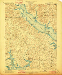
(201)- 1892 Map of Leonardtown
 1892 Leonardtown1892 Print · USGSSt. Mary's County at the end of the nineteenth century was a world of river wharves and tobacco landings. Trace the path of the Proposed Drum Point R.R. and locate family landmarks like Sotterly or Reeder Wharf along the Patuxent River.
 - 1892 Map of Drum Point
 1892 Drum Point1892 Print · USGSThe lower Chesapeake Bay and Patuxent River shoreline appear here in the early 1890s, when maritime trade governed local life. Genealogists and historians can locate old post offices like Lusby and Jarboesville or trace the early waterfront at Solomon and Drum Pt. L.H.2 unique versions available
 - 1892 Map of Prince Frederick
 1892 Prince Frederick1892 Print · USGSCalvert County at the end of the Victorian era is captured here as a landscape of tobacco landings and emerging rail. Researchers can trace the Drum Point Railroad Proposed or locate old water-access points like Magruder Ferry and Leitches Wharf.
 - 1892 Map of Brandywine
 1892 Brandywine1892 Print · USGSSouthern Maryland in the early 1890s shows a landscape of rail-driven growth and scattered crossroads. Genealogists can trace family landmarks and rail stops from Waldorf down to La Plata, including Zekiah Swamp and the Port Tobacco Sta.
 - 1892 Map of Piney Point
 1892 Piney Point1892 Print · USGSThe Potomac River tidewater is captured in the early 1890s, bridging the maritime communities of Maryland and Virginia. Genealogists can trace family lands near Kinsale, Nomini Grove, and the historic crossing at Mount Holly (Nomini Ferry).
 - 1892 Map of Montross
 1892 Montross1892 Print · USGSThe Northern Neck of Virginia is shown here in the 1890s, when life revolved around the deep waters of the Potomac and Rappahannock. Genealogists can trace old family landing sites and settlements such as Montross, Stratford, and Potomac Mills.5 unique versions available
 - 1894 Map of Wicomico
 1894 Wicomico1894 Print · USGSThe Southern Maryland tidewater and Virginia's Northern Neck are captured here in the 1890s, when river wharves and early railroads still dictated local life. Trace the old ferry crossings at Ludlow Ferry and historic landing sites like Plowdens Wharf and Wilkerson Wharf.
 - 1894 Map of Piney Point
 1894 Piney Point1894 Print · USGSThe Lower Potomac during the late nineteenth century was a world of landings, ferries, and river-dependent villages. Genealogists and historians can trace old homesteads and crossings near Mount Holly (Nomini Ferry), Kinsale, and Valley Lee.
 - 1894 Map of Point Lookout
 1894 Point Lookout1894 Print · USGSSouthern St. Mary's County at the close of the nineteenth century was a world of landings and tidewater settlements. Researchers can trace historic river access at Bacon Wharf, locate the community of Ridge (Friendship), and study the shoreline of St. George Island.2 unique versions available
 - 1895 Map of Prince Frederick
 1895 Prince Frederick1895 Print · USGSMaryland's tobacco country and river-bound peninsulas are captured in the late nineteenth century before modern bridges spanned the waters. You can trace the path of the Drum Point Proposed R. R. or locate historic river landings like Magruder Ferry and Leitches Wharf.
 - 1895 Map of Wicomico
 1895 Wicomico1895 Print · USGSSouthern Maryland and the Virginia shore come alive in this late nineteenth-century survey of the Potomac and Wicomico watersheds. Genealogists and historians can trace old river landings like Plowdens Wharf, early rail routes, and established communities from Charlotte Hall to Chaptico.
 - 1895 Map of Brandywine
 1895 Brandywine1895 Print · USGSSouthern Maryland was a landscape of rail-driven market towns and deep wetlands in the late nineteenth century. Genealogists can trace the early layout of Waldorf, follow the Pope Creek Branch, or locate family sites near Beantown and Zekiah Swamp.2 unique versions available
 - 1895 Map of Leonardtown
 1895 Leonardtown1895 Print · USGSSouthern Maryland in the 1890s is captured here as a river-centric landscape of wharves and crossroads. Researchers can trace the early maritime economy through landings like Reeder Wharf and Forest Wharf, or locate family sites in Hollywood and Leonardtown.
 - 1895 Map of Nomini
 1895 Nomini1895 Print · USGSSouthern Maryland and the Virginia tidewater shores meet along the Potomac in this late nineteenth-century survey. Genealogists can trace family holdings and river landings from Charlotte Hall down to Sotterly and the Nomini Ferry.
 - 1895 Map of Piney Point
 1895 Piney Point1895 Print · USGSThe Potomac River and its intricate Virginia and Maryland shorelines are revealed here in the late nineteenth century. Genealogists can trace family roots through landings and settlements like Kinsale, Hague, and Mount Holly (Nomini Ferry).
 - 1895 Map of Montross
 1895 Montross1895 Print · USGSWestmoreland and Richmond counties are shown in the 1890s as a thriving river-based economy on the Northern Neck peninsula. Genealogists and historians can trace family-named landings and settlements like Wirt Wharf, Montross, and Potomac Mills.2 unique versions available
 - 1898 Map of Nomini
 1898 Nomini1898 Print · USGSMaryland and Virginia's Tidewater region comes alive in the late nineteenth century as a world of river landings, rail terminals, and rural crossroads. Researchers can trace the maritime economy through Nomini Ferry and Stone Wharf, or locate ancestral homesteads near Charlotte Hall and Potomac Mills.5 unique versions available
 - 1898 Map of St. Marys
 1898 St. Marys1898 Print · USGSMaryland's tidewater region is captured here in the late nineteenth century, showing the intricate geography of the lower Chesapeake. Genealogists can trace family roots through old landings and villages like Great Mills, Toddville, and Solomons.2 unique versions available
 - 1899 Map of Patuxent
 1899 Patuxent1899 Print · USGSSouthern Maryland in the late nineteenth century was a world of river wharves and emerging rail lines. Genealogists can trace family names across landings and settlements like Bladensburg, Upper Marlboro, and Piscataway Reform School before the landscape was modernised.3 unique versions available
 - 1901 Map of Drum Point
 1901 Drum Point1901 Print · USGSThe maritime heart of the lower Chesapeake Bay comes alive in this turn-of-the-century survey of the Calvert and St. Mary’s coastline. Genealogists and historians can trace old landings and light stations like Millstone Landing, Spencers Wharf, and the Drum Pt. L.H. at the mouth of the Patuxent River.
 - 1901 Map of Prince Frederick
 1901 Prince Frederick1901 Print · USGSThe Tidewater region of Maryland is captured here at the dawn of the twentieth century, when river travel and steamship wharves still defined the local economy. Researchers can locate vanished landings and ferry crossings like Magruder Ferry, Leitch Wharf, and Lower Marlboro.
 - 1901 Map of Leonardtown
 1901 Leonardtown1901 Print · USGSMaryland's tidewater country at the turn of the century is defined by its deep reliance on the river and bay. Genealogists and historians can trace the vital maritime economy through old landings and wharves like Sotterly Wharf, Abells Wharf, and Coburns Wharf.3 unique versions available
 - 1901 Map of Piney Point
 1901 Piney Point1901 Print · USGSThe Potomac River tidewater at the opening of the twentieth century was a landscape of remote landings and river-bound commerce. Researchers can trace historic ferry crossings at Mount Holly, find the L.H. at Piney Point, or locate old mill sites like Clifton Mills.5 unique versions available
 - 1902 Map of Wicomico
 1902 Wicomico1902 Print · USGSCoastal Maryland at the turn of the century shows a landscape tied to the tides and the tracks. Trace the vital waterfront economy through Ludlow Ferry and Plowdens Wharf, or follow the path of the Southern Maryland R. R. past Charlotte Hall.5 unique versions available
 - 1903 Map of Bloodsworth Island
 1903 Bloodsworth Island1903 Print · USGSCoastal life in the Dorchester County marshes is preserved here at the turn of the century. Genealogists and maritime historians can trace the early layout of Applegarth and Holland Island alongside landmarks like Hooper Strait L.H.3 unique versions available
Showing maps 1-25 of 201
Top cities of Saint Mary's County
- Lexington Park historical maps
- Golden Beach historical maps
- Leonardtown historical maps
- Callaway historical maps
- Mechanicsville historical maps
- Charlotte Hall historical maps
See more
Frequently asked questions
- What are the different types of historical maps available for Saint Mary's County?
- What is the oldest map of Saint Mary's County?
- Where can I purchase historical maps of Saint Mary's County for my home or office?
- Where can I download high-res historical maps of Saint Mary's County?
- Are there historical topographic maps available for Saint Mary's County?
- Is there historical aerial imagery available for Saint Mary's County?
- Where are historical maps of Saint Mary's County sourced from?