1940s Maps of Gloucester, Massachusetts
Explore 7 historic maps of Gloucester from the 1940s. These maps offer a rare glimpse into what life looked like during the 1940s — showing old roads, neighborhoods, homes, and landmarks that have changed or disappeared over time.
Whether you're researching your family's past, planning a metal detecting trip, or studying how Gloucester's landscape evolved across the 1940s, these high-resolution maps are a powerful tool for exploring the history of this region.
- Focus on a specific era: All maps on this page are from the 1940s, giving you a focused view of this time period.
- See what’s changed: Compare century-old streets, trails, and buildings to today's modern landscape using overlays and satellite layers.
- Research with precision: Use these maps for genealogy, historical research, land use analysis, or educational projects.
- View, download, or print: Maps are fully viewable online in high resolution, and can be downloaded or printed for your own records.
Start exploring Gloucester's history through authentic maps from the 1940s. This is your window into the past.
Gloucester, MA maps
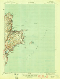
(7)- 1943 Map of Cape Ann
 1943 Cape Ann1943 Print · USGSCoastal Massachusetts and New Hampshire appear here during the wartime era, showing the maritime and rail infrastructure that defined the North Shore. Genealogists can trace family names across Asbury Grove, Merrimacport, and the Boston & Maine RR rail corridor.
 - 1945 Map of Rockport
 1945 Rockport1945 Print · USGSThe tip of Cape Ann appears here just as the wartime era ended, showing a coastal landscape defined by quarrying roots and maritime necessity. Genealogists and historians can trace the Boston and Main rail line, Beach Grove Cem, and prominent beacons like the Cape Ann Lighthouse.4 unique versions available
 - 1945 Map of Marblehead North
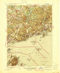 1945 Marblehead North1945 Print · USGSThe North Shore of Massachusetts during the mid-1940s shows a complex landscape of maritime heritage and rail-connected settlements. Genealogists and local historians can trace the detailed streets of Marblehead and locate landmarks like Central Cemetery and Fort Pickering.3 unique versions available
 - 1945 Map of Ipswich
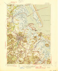 1945 Ipswich1945 Print · USGSIpswich and the surrounding Essex County coast are detailed here in the mid-1940s, highlighting a landscape defined by tidal rivers and barrier islands. Genealogists and historians can locate family landmarks such as Heartbreak Hill, the Mount Cem, and the Boston and Maine Railroad corridor.3 unique versions available
 - 1947 Map of Rockport
 1947 Rockport1947 Print · USGSThe tip of the Cape Ann peninsula is captured here just after the war, showing a landscape defined by granite shores and maritime navigation. Local historians can trace the docks of Pigeon Cove or locate the historic North Tower and Cape Ann Lighthouse on Thacher Island.
 - 1948 Map of Boston
 1948 Boston1948 Print · USGSEastern Massachusetts and southern New Hampshire appear at an industrial peak in the late 1940s, just as suburban growth began to accelerate. Genealogists and historians can trace rail lines like the Boston and Albany RR or locate coastal landmarks like Graves Lighthouse and Fort Devens.2 unique versions available
 - 1949 Map of Rockport, 1958 Print
 1949 Rockport1958 Print · USGSCape Ann's eastern tip is shown here in the late 1940s, highlighting the maritime character of Rockport and the industrial terminal of the Boston and Main railroad. Researchers can trace historic landmarks like the Cape Ann Lighthouse on Thacher Island and the residential layout around Pigeon Cove.
End of results
Showing maps 1-7 of 7
Top cities near Gloucester
- Lynn historical maps
- Salem historical maps
- Beverly historical maps
- Marblehead historical maps
- Newburyport historical maps
- Swampscott historical maps
See more
Top neighborhoods of Gloucester
- Rocky Neck historical maps
- Bass Rocks historical maps
- Five Pound Island historical maps
- Freshwater Cove Village historical maps
- Riverdale historical maps
- Riverview historical maps
See more
Frequently asked questions
- What are the different types of historical maps available for Gloucester?
- What is the oldest map of Gloucester?
- Where can I purchase historical maps of Gloucester for my home or office?
- Where can I download high-res historical maps of Gloucester?
- Are there historical topographic maps available for Gloucester?
- Is there historical aerial imagery available for Gloucester?
- Where are historical maps of Gloucester sourced from?