1970s Maps of Gloucester, Massachusetts
Explore 3 historic maps of Gloucester from the 1970s. These maps offer a rare glimpse into what life looked like during the 1970s — showing old roads, neighborhoods, homes, and landmarks that have changed or disappeared over time.
Whether you're researching your family's past, planning a metal detecting trip, or studying how Gloucester's landscape evolved across the 1970s, these high-resolution maps are a powerful tool for exploring the history of this region.
- Focus on a specific era: All maps on this page are from the 1970s, giving you a focused view of this time period.
- See what’s changed: Compare century-old streets, trails, and buildings to today's modern landscape using overlays and satellite layers.
- Research with precision: Use these maps for genealogy, historical research, land use analysis, or educational projects.
- View, download, or print: Maps are fully viewable online in high resolution, and can be downloaded or printed for your own records.
Start exploring Gloucester's history through authentic maps from the 1970s. This is your window into the past.
Gloucester, MA maps
(3)- 1970 Map of Marblehead North, 1972 Print
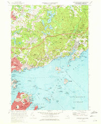 1970 Marblehead North1972 Print · USGSThe North Shore coast and the towns of Marblehead and Beverly are captured here during the early 1970s. Researchers can locate family landmarks such as Central Cemetery, historic sites like Abbot Hall, and the layout of the Boston and Maine railroad.2 unique versions available
 - 1973 Map of Rockport, 1976 Print
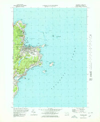 1973 Rockport1976 Print · USGSCape Ann's rugged granite coast is captured here in the early seventies, detailing the historic seafaring villages of Rockport and Pigeon Cove. Genealogists and historians can trace the Boston and Maine rail line, locate family plots at Beach Grove Cem, and spot maritime landmarks like the Cape Ann Lighthouse on Thacher Island.3 unique versions available
 - 1977 Map of Marblehead North, 1980 Print
 1977 Marblehead North1980 Print · USGSThe North Shore coastline in the late seventies is captured here through detailed aerial photography. Genealogists and historians can trace the exact 1977 footprints of coastal settlements from Marblehead and Salem up to Manchester.
End of results
Showing maps 1-3 of 3
Top cities near Gloucester
- Lynn historical maps
- Salem historical maps
- Beverly historical maps
- Marblehead historical maps
- Newburyport historical maps
- Swampscott historical maps
See more
Top neighborhoods of Gloucester
- Rocky Neck historical maps
- Bass Rocks historical maps
- Five Pound Island historical maps
- Freshwater Cove Village historical maps
- Riverdale historical maps
- Riverview historical maps
See more
Frequently asked questions
- What are the different types of historical maps available for Gloucester?
- What is the oldest map of Gloucester?
- Where can I purchase historical maps of Gloucester for my home or office?
- Where can I download high-res historical maps of Gloucester?
- Are there historical topographic maps available for Gloucester?
- Is there historical aerial imagery available for Gloucester?
- Where are historical maps of Gloucester sourced from?