Old Maps of Gloucester, Massachusetts for Metal Detecting
Plan your next treasure hunt with 61 historic maps of Gloucester. Find old homesites, ghost towns, trails, and gathering spots that may be lost to time — perfect for identifying promising metal detecting locations.
- Locate forgotten sites: Uncover places like long-lost settlements, abandoned rail lines, or gathering spots.
- Plan better hunts: Use map overlays combined with LiDAR or satellite views to narrow in on historically rich areas.
- Made for detectorists: Thousands of hobbyists use these maps to discover relics, coins, and hidden history.
Use these historic maps to boost your research and find new opportunities beneath the surface of Gloucester.
Gloucester, MA maps
(61)- 1886 Map of Gloucester
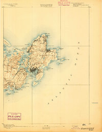
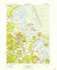
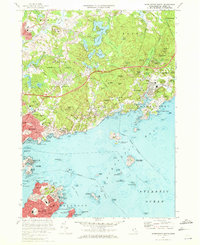
 1886 Gloucester1886 Print · USGSCape Ann at the close of the nineteenth century reveals a landscape defined by its deep granite quarries and world-famous fishing fleet. Trace the ancestral footprints of maritime families in Gloucester and Rockport, or locate long-lost stops like West Gloucester Station along the Boston and Maine Railroad.
 - 1888 Map of Gloucester
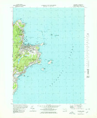
 1888 Gloucester1888 Print · USGSCape Ann's maritime landscape at the peak of the Victorian era shows a rugged coast of granite quarries and fishing ports. Trace the early tracks of the Boston and Maine Railroad and locate vanished landmarks like Freshwater Cove Village or the light at Thatchers Island.
 - 1888 Map of Salem
 1888 Salem1888 Print · USGSThe North Shore in the late nineteenth century is captured here in its era of peak rail development. Genealogists and historians can trace family-named sites like Doles Corner and institutions such as Dummer Academy or the Insane Asylum.
 - 1893 Map of Salem
 1893 Salem1893 Print · USGSCoastal Massachusetts at the end of the nineteenth century reveals a landscape defined by industrial rail lines and ancient marshlands. Genealogists and historians can trace family-named hills and early institutional sites like Dummer Academy, the Insane Asylum, and the Ipswich Light.11 unique versions available
 - 1893 Map of Gloucester
 1893 Gloucester1893 Print · USGSCape Ann's rugged maritime communities were firmly established by the 1890s, centered on the bustling port of Gloucester. Researchers can trace the coastal neighborhoods of Lanesville and Annisquam or locate family landmarks like Freshwater Cove Village and the Boston and Maine Railroad line.9 unique versions available
 - 1917 Map of Salem
 1917 Salem1917 Print · USGSCoastal Massachusetts at the end of the Great War reveals a landscape of maritime commerce and rail-connected villages. Trace the local economy from Salem Harbor to Ipswich Light, or locate historic sites like Dummer Academy and the Insane Asylum.
 - 1918 Map of Gloucester, 1921 Print
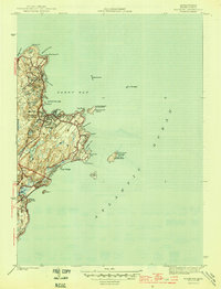
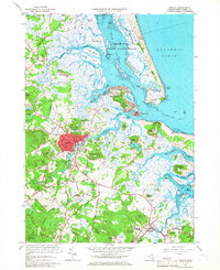
 1918 Gloucester1921 Print · USGSCape Ann's rugged shoreline and maritime villages are captured here during the first World War. Trace early twentieth-century coastal life through landmarks like Squam Light, the West Gloucester Sta., and family-named points like Wheeler Point.
 - 1919 Map of Salem
 1919 Salem1919 Print · USGSThe North Shore and its rail-connected towns are captured here during the height of the steam era. Genealogists and historians can trace the local landscape through landmarks like Dummer Academy, the Insane Asylum, and the vanished Box Factory.2 unique versions available
 - 1943 Map of Cape Ann
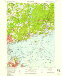
 1943 Cape Ann1943 Print · USGSCoastal Massachusetts and New Hampshire appear here during the wartime era, showing the maritime and rail infrastructure that defined the North Shore. Genealogists can trace family names across Asbury Grove, Merrimacport, and the Boston & Maine RR rail corridor.
 - 1945 Map of Rockport
 1945 Rockport1945 Print · USGSThe tip of Cape Ann appears here just as the wartime era ended, showing a coastal landscape defined by quarrying roots and maritime necessity. Genealogists and historians can trace the Boston and Main rail line, Beach Grove Cem, and prominent beacons like the Cape Ann Lighthouse.4 unique versions available
 - 1945 Map of Marblehead North
 1945 Marblehead North1945 Print · USGSThe North Shore of Massachusetts during the mid-1940s shows a complex landscape of maritime heritage and rail-connected settlements. Genealogists and local historians can trace the detailed streets of Marblehead and locate landmarks like Central Cemetery and Fort Pickering.3 unique versions available
 - 1945 Map of Ipswich
 1945 Ipswich1945 Print · USGSIpswich and the surrounding Essex County coast are detailed here in the mid-1940s, highlighting a landscape defined by tidal rivers and barrier islands. Genealogists and historians can locate family landmarks such as Heartbreak Hill, the Mount Cem, and the Boston and Maine Railroad corridor.3 unique versions available
 - 1947 Map of Rockport
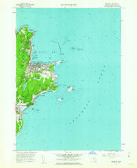
 1947 Rockport1947 Print · USGSThe tip of the Cape Ann peninsula is captured here just after the war, showing a landscape defined by granite shores and maritime navigation. Local historians can trace the docks of Pigeon Cove or locate the historic North Tower and Cape Ann Lighthouse on Thacher Island.
 - 1948 Map of Boston
 1948 Boston1948 Print · USGSEastern Massachusetts and southern New Hampshire appear at an industrial peak in the late 1940s, just as suburban growth began to accelerate. Genealogists and historians can trace rail lines like the Boston and Albany RR or locate coastal landmarks like Graves Lighthouse and Fort Devens.2 unique versions available
 - 1949 Map of Rockport, 1958 Print
 1949 Rockport1958 Print · USGSCape Ann's eastern tip is shown here in the late 1940s, highlighting the maritime character of Rockport and the industrial terminal of the Boston and Main railroad. Researchers can trace historic landmarks like the Cape Ann Lighthouse on Thacher Island and the residential layout around Pigeon Cove.
 - 1950 Map of Ipswich, 1956 Print
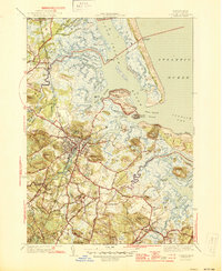
 1950 Ipswich1956 Print · USGSCoastal Massachusetts is seen here in the mid-century as a land of expansive salt marshes and historic harbor towns. Genealogists and historians can trace family-named hills and early settlements from Ipswich and Rowley to landmarks like Castle Hill and Nourse Cem.3 unique versions available
 - 1956 Map of Marblehead North, 1959 Print
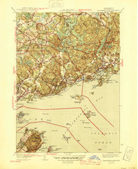
 1956 Marblehead North1959 Print · USGSThe Massachusetts North Shore flourished in the mid-1950s as classic maritime villages like Manchester and Marblehead met the expansion of the State Route 128 corridor. Genealogists and historians can trace the foundations of local institutions like Endicott Jr College, the U.S. Coast Guard Air Station, and the historic Fort Sewell.2 unique versions available
 - 1956 Map of Boston, 1967 Print
 1956 Boston1967 Print · USGSThe Massachusetts coastline and industrial interior are seen here during the mid-century peak of suburban and highway expansion. Researchers can trace historic harbor defenses like Fort Revere, local landmarks such as Faneuil Hall, and the vast Parker River National Wildlife Refuge.6 unique versions available
 - 1958 Map of Boston
 1958 Boston1958 Print · USGSEastern Massachusetts and southern New Hampshire are shown at the height of the industrial era, before the full expansion of the interstate system. Trace coastal defenses at Fort Warren, historic rail lines like the Boston and Maine, and the development of the Mass. 128 corridor.2 unique versions available
 - 1960 Map of Rockport, 1962 Print
 1960 Rockport1962 Print · USGSCape Ann's eastern tip is revealed here in the early sixties, showing a maritime landscape shaped by granite quarrying and coastal navigation. Researchers can locate family plots at Beech Grove Cem, trace the rail line of the Boston and Maine, and see the iconic Cape Ann Lighthouse on Thacher Island.2 unique versions available
 - 1961 Map of Boston
 1961 Boston1961 Print · USGSThe Massachusetts coastline and its industrial interior are detailed here in the mid-twentieth century, from the Monadnock highlands to Cape Cod. Researchers can trace the rail routes of the Boston and Maine or locate landmarks like Fort Devens and the Wachusett Reservoir.2 unique versions available
 - 1966 Map of Ipswich, 1967 Print
 1966 Ipswich1967 Print · USGSThe North Shore coast in the mid-sixties reveals a intricate landscape of salt marshes and historic town centers. Researchers can trace the legacy of family estates and religious institutions at Castle Hill, Locust Grove Cem, and the Sacred Heart Juniorate.3 unique versions available
 - 1970 Map of Marblehead North, 1972 Print
 1970 Marblehead North1972 Print · USGSThe North Shore coast and the towns of Marblehead and Beverly are captured here during the early 1970s. Researchers can locate family landmarks such as Central Cemetery, historic sites like Abbot Hall, and the layout of the Boston and Maine railroad.2 unique versions available
 - 1973 Map of Rockport, 1976 Print
 1973 Rockport1976 Print · USGSCape Ann's rugged granite coast is captured here in the early seventies, detailing the historic seafaring villages of Rockport and Pigeon Cove. Genealogists and historians can trace the Boston and Maine rail line, locate family plots at Beach Grove Cem, and spot maritime landmarks like the Cape Ann Lighthouse on Thacher Island.3 unique versions available
 - 1977 Map of Marblehead North, 1980 Print
 1977 Marblehead North1980 Print · USGSThe North Shore coastline in the late seventies is captured here through detailed aerial photography. Genealogists and historians can trace the exact 1977 footprints of coastal settlements from Marblehead and Salem up to Manchester.
Showing maps 1-25 of 61
Top cities near Gloucester
- Lynn historical maps
- Salem historical maps
- Beverly historical maps
- Marblehead historical maps
- Newburyport historical maps
- Swampscott historical maps
See more
Top neighborhoods of Gloucester
- Rocky Neck historical maps
- Bass Rocks historical maps
- Five Pound Island historical maps
- Freshwater Cove Village historical maps
- Riverdale historical maps
- Riverview historical maps
See more
Frequently asked questions
- What are the different types of historical maps available for Gloucester?
- What is the oldest map of Gloucester?
- Where can I purchase historical maps of Gloucester for my home or office?
- Where can I download high-res historical maps of Gloucester?
- Are there historical topographic maps available for Gloucester?
- Is there historical aerial imagery available for Gloucester?
- Where are historical maps of Gloucester sourced from?