1960s Maps of Gloucester, Massachusetts
Explore 3 historic maps of Gloucester from the 1960s. These maps offer a rare glimpse into what life looked like during the 1960s — showing old roads, neighborhoods, homes, and landmarks that have changed or disappeared over time.
Whether you're researching your family's past, planning a metal detecting trip, or studying how Gloucester's landscape evolved across the 1960s, these high-resolution maps are a powerful tool for exploring the history of this region.
- Focus on a specific era: All maps on this page are from the 1960s, giving you a focused view of this time period.
- See what’s changed: Compare century-old streets, trails, and buildings to today's modern landscape using overlays and satellite layers.
- Research with precision: Use these maps for genealogy, historical research, land use analysis, or educational projects.
- View, download, or print: Maps are fully viewable online in high resolution, and can be downloaded or printed for your own records.
Start exploring Gloucester's history through authentic maps from the 1960s. This is your window into the past.
Gloucester, MA maps
(3)- 1960 Map of Rockport, 1962 Print
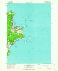 1960 Rockport1962 Print · USGSCape Ann's eastern tip is revealed here in the early sixties, showing a maritime landscape shaped by granite quarrying and coastal navigation. Researchers can locate family plots at Beech Grove Cem, trace the rail line of the Boston and Maine, and see the iconic Cape Ann Lighthouse on Thacher Island.2 unique versions available
 - 1961 Map of Boston
 1961 Boston1961 Print · USGSThe Massachusetts coastline and its industrial interior are detailed here in the mid-twentieth century, from the Monadnock highlands to Cape Cod. Researchers can trace the rail routes of the Boston and Maine or locate landmarks like Fort Devens and the Wachusett Reservoir.2 unique versions available
 - 1966 Map of Ipswich, 1967 Print
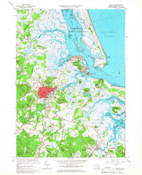 1966 Ipswich1967 Print · USGSThe North Shore coast in the mid-sixties reveals a intricate landscape of salt marshes and historic town centers. Researchers can trace the legacy of family estates and religious institutions at Castle Hill, Locust Grove Cem, and the Sacred Heart Juniorate.3 unique versions available
End of results
Showing maps 1-3 of 3
Top cities near Gloucester
- Lynn historical maps
- Salem historical maps
- Beverly historical maps
- Marblehead historical maps
- Newburyport historical maps
- Swampscott historical maps
See more
Top neighborhoods of Gloucester
- Rocky Neck historical maps
- Bass Rocks historical maps
- Five Pound Island historical maps
- Freshwater Cove Village historical maps
- Riverdale historical maps
- Riverview historical maps
See more
Frequently asked questions
- What are the different types of historical maps available for Gloucester?
- What is the oldest map of Gloucester?
- Where can I purchase historical maps of Gloucester for my home or office?
- Where can I download high-res historical maps of Gloucester?
- Are there historical topographic maps available for Gloucester?
- Is there historical aerial imagery available for Gloucester?
- Where are historical maps of Gloucester sourced from?