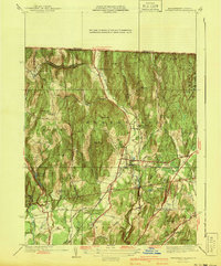
1900s (20th Century) Maps of Franklin County, Massachusetts
Explore 150 historic maps of Franklin County from the 1900s (20th Century). These maps offer a rare glimpse into what life looked like during the 1900s — showing old roads, neighborhoods, homes, and landmarks that have changed or disappeared over time.
Whether you're researching your family's past, planning a metal detecting trip, or studying how Franklin County's landscape evolved across the 1900s, these high-resolution maps are a powerful tool for exploring the history of this region.
- Focus on a specific era: All maps on this page are from the 1900s, giving you a focused view of this time period.
- See what’s changed: Compare century-old streets, trails, and buildings to today's modern landscape using overlays and satellite layers.
- Research with precision: Use these maps for genealogy, historical research, land use analysis, or educational projects.
- View, download, or print: Maps are fully viewable online in high resolution, and can be downloaded or printed for your own records.
Start exploring Franklin County's history through authentic maps from the 1900s. This is your window into the past.
Franklin County, MA maps
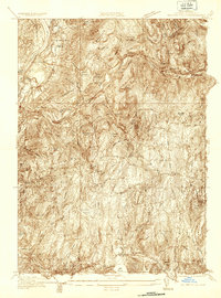
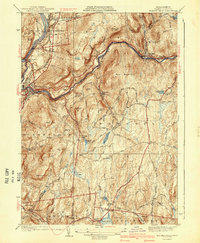
(150)- 1900 Map of Taconic
 1900 Taconic1900 Print · USGSThe tri-state border region of the Taconic Mountains thrived at the turn of the century as a hub of rail travel and valley industry. Genealogists and historians can trace the early footprints of Hoosick Falls, Bennington, and the winding path of the Rutland R.R.4 unique versions available
 - 1901 Map of Holyoke
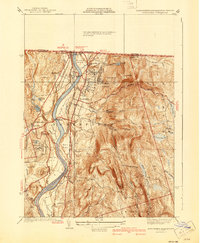
 1901 Holyoke1901 Print · USGSThe Pioneer Valley and surrounding highlands thrive at the turn of the century, showing a landscape defined by mill towns and early rail networks. Genealogists and historians can trace old homesteads and local landmarks like Bisbee Mill, South Ferry, and the Agricultural College.4 unique versions available
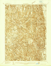
 - 1908 Map of Ware
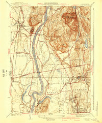
 1908 Ware1908 Print · USGSCentral Massachusetts at the turn of the century reveals the Swift River Valley decades before the Quabbin Reservoir changed the landscape forever. Trace the lost footprints of Enfield and Dana, or follow the Central Vermont RR through Greenwich Village and Ware.2 unique versions available
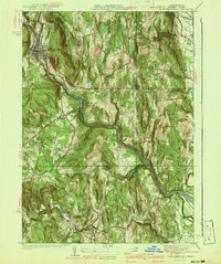
 - 1932 Map of Warwick
 1932 Warwick1932 Print · USGSIn the early 1930s, the tri-state border region of Massachusetts, New Hampshire, and Vermont was a vital corridor of rail and river transit. Genealogists and researchers can trace the old rail lines of the Central Vermont Ry, locate the East Northfield Sta, or find family landmarks like Curtis Corners and Wheeler Fall.
 - 1932 Map of Winchendon
 1932 Winchendon1932 Print · USGSThe borderlands of New Hampshire and Massachusetts come into focus during the early thirties, showing a rural landscape dominated by glacial lakes and high ridges. Researchers can trace the Boston and Maine line through State Line or locate family sites at Rand Cem and Sch No 1.
 - 1935 Map of Warwick
 1935 Warwick1935 Print · USGSUpper Massachusetts and the Tri-State borderlands thrive during the mid-thirties as rail corridors and river valleys connect mountain villages. Researchers can trace the Central Vermont Ry through Northfield or locate family landmarks like Barrows Cem and Barber Sch.2 unique versions available
 - 1935 Map of Williamsburg
 1935 Williamsburg1935 Print · USGSThe hills of Western Massachusetts are captured here in the mid-1930s as the rail and river economy of the Pioneer Valley persisted. Researchers can trace historic schoolhouses like Poland Sch, the rail terminus at Williamsburg Station, and several family-named landmarks including Joe Herrick Hill.
 - 1935 Map of Mount Toby
 1935 Mount Toby1935 Print · USGSThe Connecticut River Valley comes alive in the mid-1930s, showing the intersection of rail-and-river life. Genealogists can locate family sites near North Sunderland Cemetery, East Whately Station, and the early Massachusetts State College campus.
 - 1935 Map of Winchendon
 1935 Winchendon1935 Print · USGSIn the mid-1930s, the border between Massachusetts and New Hampshire was defined by busy rail corridors and small mill towns. Researchers can trace family-named sites and industrial infrastructure from Athol Center to Pequoig Station and the rural School No 1.4 unique versions available
 - 1936 Map of Bernardston
 1936 Bernardston1936 Print · USGSFranklin County and the Vermont border are captured in the mid-1930s when the region was a network of rural school districts and rail-side villages. Genealogists and historians can trace the locations of the The Old Cemetery or specific local schools like West Gill Sch and School No 7.
 - 1936 Map of Greenfield
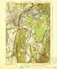
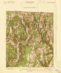
 1936 Greenfield1936 Print · USGSFranklin County is captured in the mid-1930s as a thriving rail and river hub at the heart of the Pioneer Valley. Genealogists and local historians can trace family roots through the streets of Greenfield, locate the Swedish Cem, or find the C C C Camp No 1226.
 - 1936 Map of Millers Falls
 1936 Millers Falls1936 Print · USGSFranklin County's river valleys and rail corridors are captured here in the mid-1930s. Researchers can locate family homesteads near Northfield Farms Cem, trace the vanished Tyler City, or follow the historic Mohawk Trail.
 - 1936 Map of Northfield
 1936 Northfield1936 Print · USGSIn the mid-1930s, the Connecticut River valley at the tri-state border was a landscape of rail corridors and river crossings. Trace family roots at Coller Cem, locate the Deserted Village, or find old industrial sites like Warwick Mill.
 - 1937 Map of Shelburne Falls
 1937 Shelburne Falls1937 Print · USGSFranklin County's river valleys and ridgelines are captured here in the late thirties as the Mohawk Trail and the Boston and Maine Railroad shaped local commerce. Researchers can trace family sites like the Skinner Cem or locate the old Roberts Sch and Union Ch.
 - 1937 Map of Colrain
 1937 Colrain1937 Print · USGSNorthwestern Massachusetts hill towns show their industrial and defensive roots in the years before the war. Trace colonial history at the Site of Fort Morrison or locate family homesteads near Griswoldville, Adamsville, and Aunt Sophies Peak.
 - 1937 Map of Orange
 1937 Orange1937 Print · USGSThe Millers River valley and the Franklin-Worcester county line are captured here in the late thirties. Researchers can trace the Boston and Maine Railroad through Orange or locate family sites like Wilbur Cem and Morse Village Sch.
 - 1937 Map of Mt Grace
 1937 Mt Grace1937 Print · USGSThe rural highlands of North-Central Massachusetts are captured here in the late 1930s before modern development. Researchers can trace family-named sites like Mayo Corners and Blissville, or locate early conservation landmarks like the CCC Camp and the Fire Tower on Mt Grace.
 - 1941 Map of Shelburne Falls
 1941 Shelburne Falls1941 Print · USGSFranklin County's hill towns and river valleys are captured here during the early 1940s, showing the intersection of industry and rural life. Trace the path of the Mohawk Trail and find local landmarks such as Arms Cem, Union Ch, and the settlement of Burkville.3 unique versions available
 - 1941 Map of Mt Grace
 1941 Mt Grace1941 Print · USGSThe upland villages of northern Massachusetts are captured here in the early 1940s, showing a landscape defined by high ridges and small mill ponds. Local historians can trace family-named sites from the Fire Tower on Mt Grace to Baptist Corners and Blissville.2 unique versions available
 - 1941 Map of Greenfield
 1941 Greenfield1941 Print · USGSFranklin County's river-driven industry and academic centers are on full display in this pre-war survey of the Pioneer Valley. Researchers can trace the rail networks and find local landmarks like Deerfield Academy, Lake Pleasant, and the High St Cem.3 unique versions available
 - 1941 Map of Millers Falls
 1941 Millers Falls1941 Print · USGSFranklin County's river valleys and upland hills are captured here in the years before the mid-century expansion. Genealogists can locate family names and rural landmarks such as Locks Village, the Northfield Farms Cem, and the Farley Sch.3 unique versions available
 - 1941 Map of Bernardston
 1941 Bernardston1941 Print · USGSFranklin County's rural landscape is captured here in the early 1940s as rail lines still defined the local economy. Researchers can locate numerous district schools and historic family landmarks like Hales Crossing, West Gill, and the Sunnyside Sch.3 unique versions available
 - 1941 Map of Northfield
 1941 Northfield1941 Print · USGSThe Connecticut River valley at the onset of the 1940s shows a landscape of busy rail lines and storied educational institutions. Genealogists and historians can trace Northfield landmarks like the Mt Hermon School, South Mtn Cem, and Schell Bridge.2 unique versions available
 - 1941 Map of Mt Toby
 1941 Mt Toby1941 Print · USGSThe Pioneer Valley in the mid-thirties was a vital corridor for three major rail lines and a center for higher education. Genealogists can trace family names and landmarks across Sunderland and Amherst, including Massachusetts State College and the East Whately Cem.3 unique versions available
 - 1941 Map of Colrain
 1941 Colrain1941 Print · USGSThe hill towns of Franklin County appear here in the early 1940s, showing the tight-knit industrial and farming hamlets along the North River. Genealogists and historians can trace colonial-era frontier sites like the Site of Fort Morrison or locate family roots near Griswoldville and West Leyden.2 unique versions available
Showing maps 1-25 of 150
Top cities of Franklin County
- Greenfield historical maps
- Montague historical maps
- Orange historical maps
- Deerfield historical maps
- Sunderland historical maps
- Northfield historical maps
See more
Frequently asked questions
- What are the different types of historical maps available for Franklin County?
- What is the oldest map of Franklin County?
- Where can I purchase historical maps of Franklin County for my home or office?
- Where can I download high-res historical maps of Franklin County?
- Are there historical topographic maps available for Franklin County?
- Is there historical aerial imagery available for Franklin County?
- Where are historical maps of Franklin County sourced from?