1970s Maps of Franklin County, Massachusetts
Explore 37 historic maps of Franklin County from the 1970s. These maps offer a rare glimpse into what life looked like during the 1970s — showing old roads, neighborhoods, homes, and landmarks that have changed or disappeared over time.
Whether you're researching your family's past, planning a metal detecting trip, or studying how Franklin County's landscape evolved across the 1970s, these high-resolution maps are a powerful tool for exploring the history of this region.
- Focus on a specific era: All maps on this page are from the 1970s, giving you a focused view of this time period.
- See what’s changed: Compare century-old streets, trails, and buildings to today's modern landscape using overlays and satellite layers.
- Research with precision: Use these maps for genealogy, historical research, land use analysis, or educational projects.
- View, download, or print: Maps are fully viewable online in high resolution, and can be downloaded or printed for your own records.
Start exploring Franklin County's history through authentic maps from the 1970s. This is your window into the past.
Franklin County, MA maps
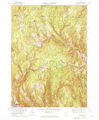
(37)- 1970 Map of Athol, 1972 Print
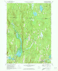
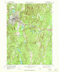 1970 Athol1972 Print · USGSAthol and Phillipston are shown during a period of steady growth along the Millers River in the early 1970s. Researchers can locate family sites and landmarks like Silver Lake Cem, Burrage Corner, and the Harvard Forest Administration Building.2 unique versions available
 - 1971 Map of Mt Toby, 1973 Print
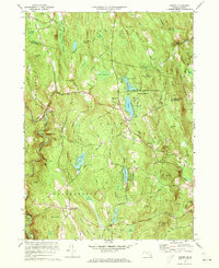
 1971 Mt Toby1973 Print · USGSMassachusetts' Pioneer Valley is shown here in the early seventies, centered on the Connecticut River corridor. Genealogists and historians can trace family sites near Wildwood Cemetery, the evolving University of Massachusetts campus, and the industrial relics at Factory Hollow.2 unique versions available
 - 1971 Map of Ashfield, 1973 Print
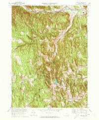 1971 Ashfield1973 Print · USGSFranklin County's hill towns and river valleys are shown here in the early 1970s as agricultural life and modern infrastructure intersected. Researchers can trace family sites at Sanderson Academy and the Ashfield Plain Cem or follow the old Boston and Maine rail line.3 unique versions available
 - 1971 Map of Plainfield, 1973 Print
 1971 Plainfield1973 Print · USGSThe Massachusetts highlands of the early 1970s reveal a landscape of dense state forests and quiet upland hamlets. Genealogists and hikers can trace old family burial grounds like Hilltop Cem or explore landmarks such as Windsor Jambs and Plainfield Pond.2 unique versions available
 - 1971 Map of Royalston, 1973 Print
 1971 Royalston1973 Print · USGSThe Worcester County highlands are captured here in the early 1970s, showing the distinct settlements of Royalston and South Royalston before modern development. You can trace family history through the Center Cem and Riverside Cem or follow the historic Boston and Maine rail line along the Millers River.5 unique versions available
 - 1972 Map of Goshen, 1973 Print
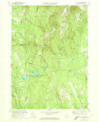
 1972 Goshen1973 Print · USGSGoshen and its surrounding highlands appear here in the early 1970s, showcasing a landscape of state forests and summer camps. Genealogists can trace family landmarks like Goshen Cem, Davenport Sch, and the remote Devils Den.4 unique versions available
 - 1973 Map of North Adams, 1975 Print
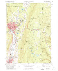 1973 North Adams1975 Print · USGSNorth Adams and its neighboring mountain townships are shown in the early seventies, a landscape where industrial valleys meet state forest peaks. Genealogists and historians can trace rail routes through the Hoosac Tunnel or locate ancestral sites like Hillside Cem and Briggsville.4 unique versions available
 - 1973 Map of Rowe, 1975 Print
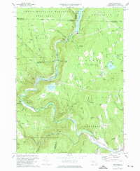 1973 Rowe1975 Print · USGSFranklin County's northwestern highlands appear in the 1970s as a landscape of hydroelectric power and deep-bore rail engineering. You can trace the path of the Mohawk Trail, locate the Hoosac Tunnel entrance, and find small family landmarks like West Cem and Phelps Hill.4 unique versions available
 - 1974 Map of Heath, 1976 Print
 1974 Heath1976 Print · USGSThe Massachusetts-Vermont borderlands in the mid-1970s reveal a landscape of isolated hill towns and deep-rooted family history. Genealogists and hikers can trace the connections between upland settlements like North Heath and Adamsville or find old burial sites at Cutting Cem and Christian Hill Cem.2 unique versions available
 - 1975 Map of Northfield, 1981 Print
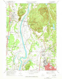
 1975 Northfield1981 Print · USGSThe Connecticut River valley during the mid-seventies is captured in this detailed aerial view of the Massachusetts and New Hampshire borderlands. Researchers can trace the exact footprint of riverfront settlements like Northfield and rural junctions such as Curtis Corner or Gill Station.
 - 1975 Map of Orange, 1981 Print
 1975 Orange1981 Print · USGSFranklin County's industrial and rural landscape is seen from above in the mid-seventies, centered on the river-front town of Orange. Researchers can trace the layout of Orange, the northern reaches of the Quabbin Reservoir, and the airfield at The Plains.
 - 1975 Map of Winsor Dam, 1981 Print
 1975 Winsor Dam1981 Print · USGSThe Quabbin Reservoir region in the mid-seventies shows a landscape defined by the balance of engineering and nature. Trace the southern shoreline from Winsor Dam down to the settlements of West Ware and Ware along the Swift River.
 - 1975 Map of Athol, 1981 Print
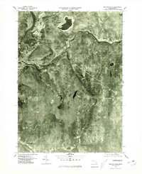
 1975 Athol1981 Print · USGSThe Worcester County highlands in the mid-seventies appear in striking aerial detail, showing the contrast between riverside industry and dense forest. Genealogists and historians can trace the rural layouts of Phillipston, Phillipston Four Corners, and the settlement at Athol.
 - 1975 Map of Mt Toby, 1981 Print
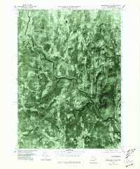
 1975 Mt Toby1981 Print · USGSThe Pioneer Valley mid-century agricultural landscape is frozen in time in this 1970s aerial survey. Genealogists and local historians can trace the field patterns and original footprints of Sunderland, South Deerfield, and Russellville.
 - 1975 Map of Bernardston, 1981 Print
 1975 Bernardston1981 Print · USGSFranklin County, Massachusetts is captured in the mid-seventies through detailed aerial photography showing the intersection of forest and industry. Genealogists and local historians can trace exact property layouts and land use around Bernardston, Hales Crossing, and along the Fall River.
 - 1975 Map of Millers Falls, 1981 Print
 1975 Millers Falls1981 Print · USGSFranklin County in the mid-seventies is captured here through detailed aerial imagery showing the river-valley settlements of the Connecticut and Millers rivers. Researchers can trace the layout of villages like Millers Falls, Farley, and Locks Village.
 - 1975 Map of Royalston, 1981 Print
 1975 Royalston1981 Print · USGSRoyalston and the northern Worcester County highlands are seen here in the mid-seventies through detailed aerial orthophotography. Researchers can trace the village layouts of West Royalston and Tully or the natural shorelines of Laurel Lake.
 - 1975 Map of Plainfield, 1981 Print
 1975 Plainfield1981 Print · USGSThe hill towns of western Massachusetts appear in the mid-1970s as a landscape of dense timber and quiet rural crossroads. Researchers can trace the exact footprint of settlements like West Hawley and Plainfield or find the remote shores of Windsor Pond.
 - 1975 Map of Mt Grace, 1981 Print
 1975 Mt Grace1981 Print · USGSWarwick and the surrounding Franklin County highlands are captured in this mid-seventies aerial study of the Massachusetts-New Hampshire border. Genealogists and historians can trace the exact 1975 footprint of Warwick, Mayo Corners, and Moores Pond.
 - 1975 Map of Heath, 1981 Print
 1975 Heath1981 Print · USGSFranklin County's upland townships are captured in 1975 aerial imagery, documenting the rural landscape of the northern Berkshires during the mid-seventies. Researchers can trace the clearings around Heath and Adamsville or follow the deep valley of the West Branch North River.
 - 1975 Map of Shelburne Falls, 1981 Print
 1975 Shelburne Falls1981 Print · USGSFranklin County's upland farms and river valleys are captured in the mid-seventies, showing the area's transition into the modern era. Trace the landscape around Shelburne Falls, the winding Deerfield River, and the rural crossroads of Shirkshire.
 - 1975 Map of Rowe, 1981 Print
 1975 Rowe1981 Print · USGSThe northern Berkshires and Deerfield River valley appear in high detail during the mid-seventies. Trace the path of the Hoosac Tunnel and explore settlements like Monroe Bridge, Rowe, and Zoar amidst the dense forest and reservoirs.
 - 1975 Map of Williamsburg, 1981 Print
 1975 Williamsburg1981 Print · USGSWilliamsburg and the surrounding hill towns appear in high-altitude detail during the mid-seventies. Local historians can trace the building footprints in Williamsburg, find the residential clusters of Searsville, and follow the course of the Mill River.
 - 1975 Map of Colrain, 1981 Print
 1975 Colrain1981 Print · USGSFranklin County's rural landscape is revealed in this mid-seventies aerial survey of the Massachusetts-Vermont border. Trace the historic river settlements of Colrain, Foundry Village, and Griswoldville along the winding North River.
 - 1975 Map of Shutesbury, 1981 Print
 1975 Shutesbury1981 Print · USGSFranklin County's wooded highlands and the massive Quabbin Reservoir are shown in this mid-1970s aerial survey. Researchers can trace the roads and homesteads of Shutesbury, Locks Village, and Pelham as they sat in the landscape nearly fifty years ago.
Showing maps 1-25 of 37
Top cities of Franklin County
- Greenfield historical maps
- Montague historical maps
- Orange historical maps
- Deerfield historical maps
- Sunderland historical maps
- Northfield historical maps
See more
Frequently asked questions
- What are the different types of historical maps available for Franklin County?
- What is the oldest map of Franklin County?
- Where can I purchase historical maps of Franklin County for my home or office?
- Where can I download high-res historical maps of Franklin County?
- Are there historical topographic maps available for Franklin County?
- Is there historical aerial imagery available for Franklin County?
- Where are historical maps of Franklin County sourced from?