1990s Maps of Franklin County, Massachusetts
Explore 15 historic maps of Franklin County from the 1990s. These maps offer a rare glimpse into what life looked like during the 1990s — showing old roads, neighborhoods, homes, and landmarks that have changed or disappeared over time.
Whether you're researching your family's past, planning a metal detecting trip, or studying how Franklin County's landscape evolved across the 1990s, these high-resolution maps are a powerful tool for exploring the history of this region.
- Focus on a specific era: All maps on this page are from the 1990s, giving you a focused view of this time period.
- See what’s changed: Compare century-old streets, trails, and buildings to today's modern landscape using overlays and satellite layers.
- Research with precision: Use these maps for genealogy, historical research, land use analysis, or educational projects.
- View, download, or print: Maps are fully viewable online in high resolution, and can be downloaded or printed for your own records.
Start exploring Franklin County's history through authentic maps from the 1990s. This is your window into the past.
Franklin County, MA maps
(15)- 1990 Map of Ashfield
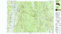
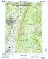
 1990 Ashfield1990 Print · USGSFranklin County's high country is captured here in the late twentieth century, showing a landscape of small hill towns and protected forests. Researchers can trace family sites at Pudding Hollow Cem or explore early settlements like Plainfield and South Hawley.2 unique versions available
 - 1990 Map of Northfield
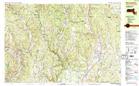
 1990 Northfield1990 Print · USGSThe tri-state border of Massachusetts, New Hampshire, and Vermont comes into focus in the 1990s as a landscape of river valleys and forested peaks. Researchers can trace the grounds of the Northfield Mt Hermon School or locate old burial sites like South Parish Cem and Center Cem.2 unique versions available
 - 1990 Map of Shutesbury
 1990 Shutesbury1990 Print · USGSFranklin County's landscape appears here in the final decade of the century, shaped by the massive waters of the Quabbin Reservoir. Genealogists and local historians can trace the remnants of displaced communities like Prescott Center and locate rural landmarks such as Fairview Cem and Locks Village.2 unique versions available
 - 1990 Map of Bernardston
 1990 Bernardston1990 Print · USGSFranklin County and the Vermont borderlands appear in the early nineties as a blend of Colonial frontier sites and industrial river hamlets. Researchers can locate historic fortifications like Fort Morrison (Site), rural schools like Leyden Sch, and family-named cemeteries such as Grove Cem.2 unique versions available
 - 1990 Map of Orange
 1990 Orange1990 Print · USGSFranklin County's river valleys and state forests are meticulously detailed in the late twentieth century, showing the intersection of industry and nature. Genealogists can locate family burial sites at Dry Hill Cem and Wilbur Cem or trace the path of the Boston and Maine RR.2 unique versions available
 - 1990 Map of Rowe
 1990 Rowe1990 Print · USGSThe Deerfield River valley of northern Franklin County comes into focus in the 1980s, balancing industrial sites with large tracts of state forest. Genealogists and local historians can locate several family cemeteries, the Davis Mine, and the iconic Hoosac Tunnel.2 unique versions available
 - 1990 Map of Greenfield
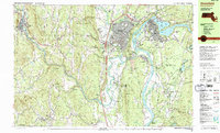 1990 Greenfield1990 Print · USGSUpper Massachusetts in the early nineties reveals a landscape of river-powered industry and prestigious academies. Genealogists and historians can trace family plots at Old Albany Cem or locate the sprawling campuses of Bement Sch and Greenfield Community College.3 unique versions available
 - 1990 Map of Goshen
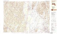
 1990 Goshen1990 Print · USGSHampshire County in the early nineties remains a landscape of deep river valleys and high forest ridges. Genealogists and historians can locate rural landmarks like Goshen Cem, the Cummington Fairgrounds, and the Davenport Sch.
 - 1990 Map of Williamsburg
 1990 Williamsburg1990 Print · USGSIn the Pioneer Valley during the late twentieth century, the landscape transitioned from the rural hills of Williamsburg to the growing University of Massachusetts campus. Genealogists can trace family names at Whately Center Cem or Riverside Cem and find industrial landmarks like Factory Hollow.2 unique versions available
 - 1997 Map of Goshen, 1999 Print
 1997 Goshen1999 Print · USGSThe hill towns of Hampshire County come into focus in the late 1990s, where protected state forests meet historic valley settlements along the Westfield River. Genealogists and historians can locate the Cummington Fairgrounds, Lithia Chapel, and several family-named burial sites like Dawes Cem.
 - 1997 Map of Rowe, 2000 Print
 1997 Rowe2000 Print · USGSThe Berkshires of Franklin County meet the Vermont border in the 1990s, showcasing a landscape of state forests and hydroelectric engineering. Trace the legendary Hoosac Tunnel rail line and locate local landmarks like the Rowe Sch, West Cem, and the settlement of Monroe Bridge.
 - 1997 Map of North Adams, 2000 Print
 1997 North Adams2000 Print · USGSNorthern Berkshire County industrial life and rugged mountain passes meet in the 1990s as the Hoosic River flows through North Adams. Trace family roots at Southview Cem, locate the old stop at Zylonite, or follow the Mohawk Trail past Whitcomb Summit.
 - 1998 Map of Ashfield, 2000 Print
 1998 Ashfield2000 Print · USGSFranklin County's highland towns are shown here in the late twentieth century, before major changes to their rural character. Genealogists can trace family names through sites like Hilltop Cemetery or Pudding Hollow Cemetery and explore old centers like West Hawley or Spruce Corner.
 - 1998 Map of Bernardston, 2000 Print
 1998 Bernardston2000 Print · USGSThe hill country of Franklin County at the turn of the millennium shows a landscape of river-valley settlements and upland forests. Genealogists can locate family landmarks like Chandler Hill Cem, the Leyden Sch, and the riverside industrial hamlets of Foundry Village and Griswoldville.
 - 1998 Map of Rowe, 2001 Print
 1998 Rowe2001 Print · USGSThe northern Berkshires and southern Green Mountains met at a crossroads of energy production and conservation in the late twentieth century. Researchers can locate remote burial sites like Christian Hill Cem, the eastern portal of the Hoosac Tunnel, and the historic Davis Mine.
End of results
Showing maps 1-15 of 15
Top cities of Franklin County
- Greenfield historical maps
- Montague historical maps
- Orange historical maps
- Deerfield historical maps
- Sunderland historical maps
- Northfield historical maps
See more
Frequently asked questions
- What are the different types of historical maps available for Franklin County?
- What is the oldest map of Franklin County?
- Where can I purchase historical maps of Franklin County for my home or office?
- Where can I download high-res historical maps of Franklin County?
- Are there historical topographic maps available for Franklin County?
- Is there historical aerial imagery available for Franklin County?
- Where are historical maps of Franklin County sourced from?