1960s Maps of Franklin County, Massachusetts
Explore 16 historic maps of Franklin County from the 1960s. These maps offer a rare glimpse into what life looked like during the 1960s — showing old roads, neighborhoods, homes, and landmarks that have changed or disappeared over time.
Whether you're researching your family's past, planning a metal detecting trip, or studying how Franklin County's landscape evolved across the 1960s, these high-resolution maps are a powerful tool for exploring the history of this region.
- Focus on a specific era: All maps on this page are from the 1960s, giving you a focused view of this time period.
- See what’s changed: Compare century-old streets, trails, and buildings to today's modern landscape using overlays and satellite layers.
- Research with precision: Use these maps for genealogy, historical research, land use analysis, or educational projects.
- View, download, or print: Maps are fully viewable online in high resolution, and can be downloaded or printed for your own records.
Start exploring Franklin County's history through authentic maps from the 1960s. This is your window into the past.
Franklin County, MA maps
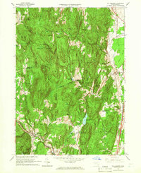
(16)- 1960 Map of North Adams, 1961 Print
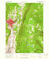 1960 North Adams1961 Print · USGSThe Northern Berkshires in the early 1960s reveal a landscape where industrial river towns like NORTH ADAMS and Adams meet high mountain forests. Genealogists and historians can trace local roots through Southview Cem, visit the Natural Bridge, or follow the BOSTON AND MAINE RAILROAD through Zylonite.2 unique versions available
 - 1960 Map of Rowe, 1961 Print
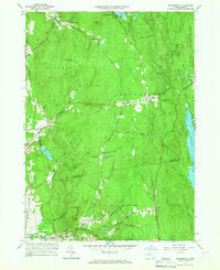
 1960 Rowe1961 Print · USGSThe Berkshires at the start of the 1960s show a landscape shaped by the Deerfield River and the industrial infrastructure of the Boston and Maine RR. Genealogists and historians can trace family plots at Sherman Cem or locate the famed Hoosac Tunnel and the mills at Monroe Bridge.2 unique versions available
 - 1961 Map of Heath, 1962 Print
 1961 Heath1962 Print · USGSThe Berkshire foothills of the early 1960s are revealed here, showing the rural landscape of Heath and Colrain along the Vermont border. Genealogists and researchers can locate several remote burial grounds like Center Cem and Panel Hill Cem, or trace the historical Mohawk Trail along the Deerfield River.2 unique versions available
 - 1961 Map of Millers Falls, 1963 Print
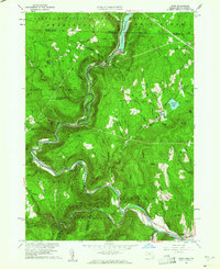
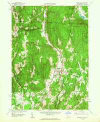
 1961 Millers Falls1963 Print · USGSFranklin County's river-driven industrial hubs and forested uplands are documented here in the early sixties. Researchers can trace the rail junction at Millers Falls, find remote burial sites like Dry Hill Cem, and explore the shoreline of Lake Wyola.2 unique versions available
 - 1961 Map of Orange, 1963 Print
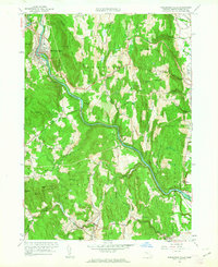
 1961 Orange1963 Print · USGSOrange and the Millers River valley are captured here in the early sixties as industrial rail hubs transitioned into a landscape of sprawling state forests. Trace historic village sites like Morse Village and Wendell Depot, or locate family landmarks near Lake Mattawa.2 unique versions available
 - 1961 Map of Mt Grace, 1963 Print
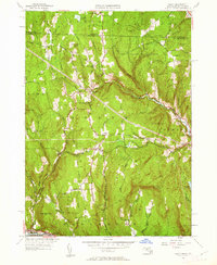
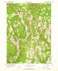
 1961 Mt Grace1963 Print · USGSUpper Franklin County and the New Hampshire borderlands are captured here in the early 1960s as a region of forestry and small rural hamlets. Genealogists can locate family sites at South Cem or Newton Cem, while hikers can trace the terrain around Mt Grace and Tully Mtn.
 - 1961 Map of Bernardston, 1963 Print
 1961 Bernardston1963 Print · USGSThe Massachusetts and Vermont borderlands come into focus in the early sixties as the modern interstate era begins to reshape the river valleys. Researchers can locate family burial sites at Beaver Meadow Cem or trace the old Boston and Maine Railroad through Bernardston and Hales Crossing.2 unique versions available
 - 1961 Map of Colrain, 1963 Print
 1961 Colrain1963 Print · USGSNorthwestern Massachusetts in the early sixties remains a landscape of river-valley industry and colonial frontier sites. Researchers can trace the heritage of Colrain and Leyden through numerous family-named landmarks like Franklin Hill and historic locations such as Fort Morrison (Site).2 unique versions available
 - 1961 Map of Shelburne Falls, 1963 Print
 1961 Shelburne Falls1963 Print · USGSThe Deerfield River valley in the early 1960s reveals a landscape of steep ridges and tight-knit villages connected by the Boston and Maine railroad. Genealogists can trace family names through numerous burial grounds like Hawks Cem or locate former schoolhouses such as Roberts Sch near East Hill.2 unique versions available
 - 1961 Map of Northfield, 1963 Print
 1961 Northfield1963 Print · USGSThe Connecticut River valley at the tri-state border was a hub of academic and rail life in the early sixties. Genealogists can trace family plots at West Northfield Cem and Coller Cem or locate the sprawling grounds of the Northfield School for Boys.2 unique versions available
 - 1962 Map of Albany
 1962 Albany1962 Print · USGSThe Hudson and Connecticut River valleys meet the Green Mountains and Berkshires in this mid-century overview of the Northeast. Genealogists and historians can trace the industrial hearts of Albany and Springfield or locate features like Quabbin Reservoir and Westover Air Force Base.
 - 1964 Map of Williamsburg, 1966 Print
 1964 Williamsburg1966 Print · USGSThe Pioneer Valley foothills and Hill Towns come to life in the mid-1960s, showing the intersection of rail, river, and mountain. Genealogists can trace family roots through the Whately Center Cem or locate the old Williamsburg Station along the Boston and Maine Railroad.4 unique versions available
 - 1964 Map of Shutesbury, 1966 Print
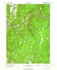
 1964 Shutesbury1966 Print · USGSThe wooded uplands and reservoir shores of central Massachusetts are captured here in the mid-sixties. Genealogists and hikers can trace the foundations of the region through landmarks like Plainview Cem, Locks Village, and the site of the old Coke Ovens.4 unique versions available
 - 1967 Map of Quabbin Reservoir, 1969 Print
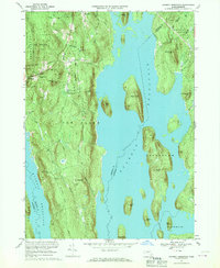 1967 Quabbin Reservoir1969 Print · USGSThe Quabbin Reservoir region is shown here in the late sixties, following the mid-century transformation of the Swift River Valley into a massive watershed. Genealogists and hikers can trace the remains of North Prescott, find the Mtn View Cem, and explore islands like Mount Zion.2 unique versions available
 - 1967 Map of Winsor Dam, 1969 Print
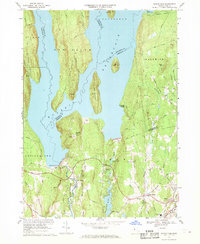 1967 Winsor Dam1969 Print · USGSThe southern reaches of the Quabbin Reservoir are documented here in the late sixties, highlighting the massive water infrastructure of the Swift River Valley. Trace the locations of Winsor Dam, West Ware, and the Quabbin Park Cemetery.3 unique versions available
 - 1968 Map of Greenfield, 1979 Print
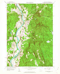
 1968 Greenfield1979 Print · USGSThe industrial and academic heart of the Connecticut River Valley is captured here in the late sixties. Genealogists and historians can trace the campuses of Deerfield Academy and Eagle Brook School, along with the rail yards at East Deerfield and the historic Poets Seat.
End of results
Showing maps 1-16 of 16
Top cities of Franklin County
- Greenfield historical maps
- Montague historical maps
- Orange historical maps
- Deerfield historical maps
- Sunderland historical maps
- Northfield historical maps
See more
Frequently asked questions
- What are the different types of historical maps available for Franklin County?
- What is the oldest map of Franklin County?
- Where can I purchase historical maps of Franklin County for my home or office?
- Where can I download high-res historical maps of Franklin County?
- Are there historical topographic maps available for Franklin County?
- Is there historical aerial imagery available for Franklin County?
- Where are historical maps of Franklin County sourced from?