1960s Maps of Leominster, Massachusetts
Explore 5 historic maps of Leominster from the 1960s. These maps offer a rare glimpse into what life looked like during the 1960s — showing old roads, neighborhoods, homes, and landmarks that have changed or disappeared over time.
Whether you're researching your family's past, planning a metal detecting trip, or studying how Leominster's landscape evolved across the 1960s, these high-resolution maps are a powerful tool for exploring the history of this region.
- Focus on a specific era: All maps on this page are from the 1960s, giving you a focused view of this time period.
- See what’s changed: Compare century-old streets, trails, and buildings to today's modern landscape using overlays and satellite layers.
- Research with precision: Use these maps for genealogy, historical research, land use analysis, or educational projects.
- View, download, or print: Maps are fully viewable online in high resolution, and can be downloaded or printed for your own records.
Start exploring Leominster's history through authentic maps from the 1960s. This is your window into the past.
Leominster, MA maps
(5)- 1961 Map of Boston
 1961 Boston1961 Print · USGSThe Massachusetts coastline and its industrial interior are detailed here in the mid-twentieth century, from the Monadnock highlands to Cape Cod. Researchers can trace the rail routes of the Boston and Maine or locate landmarks like Fort Devens and the Wachusett Reservoir.2 unique versions available
 - 1965 Map of Shirley, 1968 Print
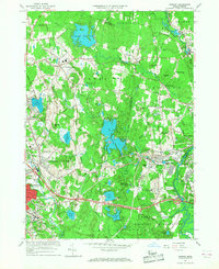 1965 Shirley1968 Print · USGSShirley and the surrounding Worcester County uplands are captured here in the mid-sixties as military operations and industrial growth intersected. Genealogists and historians can trace the footprint of Fort Devens, the State Industrial Sch for Boys, and the village layout of Shirley Center.3 unique versions available
 - 1965 Map of Clinton, 1968 Print
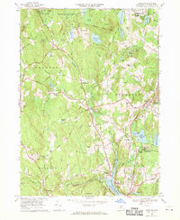
 1965 Clinton1968 Print · USGSClinton and the Nashua River valley are shown here in the mid-sixties as the region balanced its industrial past with expanding infrastructure. Researchers can locate the Wachusett Aqueduct, the campus of Atlantic Union College, and numerous historic burial grounds like Old Settlers Cem.2 unique versions available
 - 1968 Map of Sterling, 1970 Print
 1968 Sterling1970 Print · USGSWorcester County's reservoir landscape is captured here in the late sixties, showcasing the vital water infrastructure and small towns around Sterling. Genealogists and historians can trace family locations near the Sterling Camp Grounds, High Plain Cem, or the old Boston & Maine Railroad line.3 unique versions available
 - 1969 Map of Fitchburg, 1972 Print
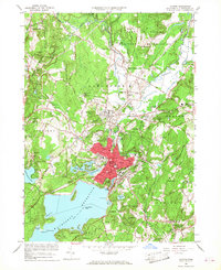
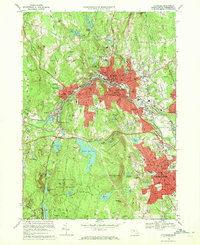 1969 Fitchburg1972 Print · USGSThe industrial hubs of Fitchburg and Leominster are captured here during a period of mid-century growth and urban density. Genealogists and local historians can trace legacy sites like St Joseph Cem, the Fitchburg State College campus, and the rail junction at Wachusett Station.2 unique versions available
End of results
Showing maps 1-5 of 5
Top cities near Leominster
- Worcester historical maps
- Nashua historical maps
- Fitchburg historical maps
- Marlborough historical maps
- Shrewsbury historical maps
- Gardner historical maps
See more
Top neighborhoods of Leominster
- Gates Crossing historical maps
- West Leominster historical maps
- North Leominster historical maps
- Monument Square Historic District historical maps
Frequently asked questions
- What are the different types of historical maps available for Leominster?
- What is the oldest map of Leominster?
- Where can I purchase historical maps of Leominster for my home or office?
- Where can I download high-res historical maps of Leominster?
- Are there historical topographic maps available for Leominster?
- Is there historical aerial imagery available for Leominster?
- Where are historical maps of Leominster sourced from?