Old Maps of Leominster, Massachusetts for Genealogy
Trace your family roots with 73 historic maps of Leominster. These high-res maps reveal old neighborhoods, homesites, landmarks, and streets — helping you uncover where your ancestors lived and how the area evolved over time.
- Explore historic neighborhoods: Identify where your relatives may have lived in the 1800s or 1900s.
- Compare maps over time: Trace the changes in streets, buildings, and landmarks for multi-generational research.
- Perfect for genealogy & ancestry research: Used by family historians and researchers to map out lineage and migration.
These maps are an incredible resource for exploring your personal connection to Leominster's past.
Leominster, MA maps
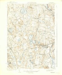
(73)- 1885 Map of Worcester
 1885 Worcester1885 Print · USGSWorcester and its surrounding mill towns are captured here in the late nineteenth century during a peak era of rail expansion and industrial growth. Researchers can trace ancestral roots through specific local hubs like Wire Village, the Sterling Camp Grounds, and the grounds of the State Lunatic Hospital.
 - 1886 Map of Worcester
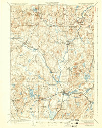
 1886 Worcester1886 Print · USGSWorcester and its surrounding hill towns are captured here in the mid-1880s, revealing a landscape of early industrial hamlets and expanding rail lines. Genealogists and local historians can trace the foundations of the State Lunatic Hospital or locate historic settlements like Quinapoxet Village and Wire Village.
 - 1887 Map of Marlboro
 1887 Marlboro1887 Print · USGSWorcester County is captured during its industrial transition, showing the vital rail and water networks connecting the region. Researchers can trace the development of the Metropolitan Waterworks Aqueduct and locate landmarks like the Westboro Insane Hospital and Lyman School.
 - 1887 Map of Fitchburg
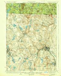
 1887 Fitchburg1887 Print · USGSThe hills of Worcester County were a beehive of rail and industry when this survey was conducted. Trace the original routes of the Fitchburg Railroad and find long-established local centers like Wachusett Village, Converse Ville, and Rollstone Hill.
 - 1889 Map of Marlboro
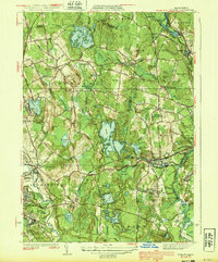
 1889 Marlboro1889 Print · USGSCentral Massachusetts at the close of the 1880s was a bustling hub of rail activity and industrial development. Local historians can trace early transportation routes like the Fitchburg Railroad through Still River Station and find old-world village names like Rock Bottom and Straw Hollow.
 - 1889 Map of Fitchburg
 1889 Fitchburg1889 Print · USGSNorth-central Massachusetts and southern New Hampshire are captured here in the late Victorian era as industry and rail expanded. Genealogists can trace family homesteads near Whitmanville or locate specific rail depots like Ashburnham Junction and Westminster Station.
 - 1892 Map of Worcester
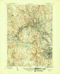
 1892 Worcester1892 Print · USGSWorcester and its northern hill towns are captured here in the late nineteenth century before the expansion of modern reservoirs. Researchers can trace the early rail networks through Sterling Junction or locate landmarks like the State Lunatic Hospital and Wire Village.10 unique versions available
 - 1893 Map of Fitchburg
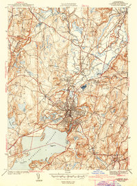
 1893 Fitchburg1893 Print · USGSNorth-central Massachusetts at the close of the nineteenth century was a complex network of industrial valley towns and highland rail junctions. You can trace the path of the Cheshire Railroad as it winds past Lake Monomonac or explore the early street layouts of Fitchburg and Leominster.7 unique versions available
 - 1893 Map of Groton, 1905 Print
 1893 Groton1905 Print · USGSNorthern Massachusetts and the New Hampshire borderlands are shown here in the late nineteenth century as a hub of river industry and rail commerce. Researchers can trace historic sites like Shaker Village, the Groton School, and manufacturing hubs at Paper Mill Village.8 unique versions available
 - 1896 Map of Marlboro
 1896 Marlboro1896 Print · USGSCentral Massachusetts in the late nineteenth century is a landscape of thriving mill towns and interlocking rail lines. Researchers can trace the Victorian-era footprints of Marlboro and Clinton, locating vanished stops like Still River Station and family landmarks like Whittemore Hill.
 - 1898 Map of Marlboro
 1898 Marlboro1898 Print · USGSCentral Massachusetts was a thriving network of rail and river industry at the end of the Victorian era. Genealogists and historians can trace the early layouts of manufacturing hubs like Clinton and Hudson or find smaller vanished locales like Rockbottom and Pratt Junction.8 unique versions available
 - 1908 Map of Quinsigamond
 1908 Quinsigamond1908 Print · USGSCentral Massachusetts and its bordering states are seen here in the early twentieth century as industry and transit reshaped the Blackstone Valley. Genealogists and historians can trace the early footprints of Worcester, the expansion of the Wachusett Reservoir, and rail lines like the Boston and Albany Railroad.3 unique versions available
 - 1935 Map of Groton
 1935 Groton1935 Print · USGSCrossing the New Hampshire border in the 1930s, this area was a bustling hub of rail transport and riverside industry. Researchers can trace the legacy of communal life at Shaker Village, locate the campus of Groton School, or follow the lines of the Boston and Maine RR through towns like Pepperell and Shirley.
 - 1935 Map of Fitchburg
 1935 Fitchburg1935 Print · USGSThe industrial corridor and border hills of north-central Massachusetts and southern New Hampshire are captured here in the mid-1930s. Trace the intricate rail networks of the Old Colony Railroad and find local landmarks like School No 8 or Rollstone Hill.3 unique versions available
 - 1935 Map of Shirley
 1935 Shirley1935 Print · USGSThe Nashua River valley during the mid-1930s shows a region defined by its rail connections and hilltop villages. Genealogists can trace family sites near Shirley Center, the Industrial School, and cemeteries like St Leo Cem.3 unique versions available
 - 1936 Map of Groton
 1936 Groton1936 Print · USGSNorthern Middlesex County and southern New Hampshire appear here in the mid-1930s, showing a landscape shaped by river power and a dense rail network. Researchers can trace historic sites like the Shaker Village and Groton School, or locate old depots at Townsend Harbor and Ayer.3 unique versions available
 - 1936 Map of Fitchburg
 1936 Fitchburg1936 Print · USGSNorthwestern Massachusetts and southern New Hampshire are shown here during the mid-1930s, featuring a mature network of rail lines and industrial river towns. Genealogists can locate family landmarks like School No 9 or trace the early paths of the Fitchburg Railroad and Old Colony Railroad Fitchburg Branch.2 unique versions available
 - 1939 Map of Shirley
 1939 Shirley1939 Print · USGSWorcester and Middlesex counties are shown in the late thirties, when rail lines and river valleys defined the region's industrial and social life. Genealogists and researchers can locate the Industrial School, family-named landmarks like Kezar Hill, and numerous cemeteries including St Cecelia Cemetery.3 unique versions available
 - 1940 Map of Sterling
 1940 Sterling1940 Print · USGSWorcester County communities like Oakdale and Sterling appear just before the mid-century, defined by the expansion of the regional water supply. Researchers can trace the path of the Quabbin Aqueduct or locate family landmarks like the Sterling Camp Grounds and Legge Cem.2 unique versions available
 - 1942 Map of Sterling
 1942 Sterling1942 Print · USGSNorthern Worcester County is shown here in the early 1940s during the development of major water infrastructure. Local historians can trace the Quagbin Aqueduct, see the Sterling Camp Grounds, and locate family burial sites like Legge Cem.
 - 1943 Map of Clinton
 1943 Clinton1943 Print · USGSMid-century Worcester County is defined here by the massive Wachusett Reservoir and the busy industrial corridor of the Nashua River. Genealogists and historians can trace the foundations of CLINTON, the grounds of Atlantic Union College, and wartime boundaries of Fort Devens.3 unique versions available
 - 1943 Map of Fitchburg
 1943 Fitchburg1943 Print · USGSSouthern New Hampshire and northern Massachusetts are captured during the war years, showing a landscape of river-powered mill towns and mountain trails. You can trace family roots in Peterboro, locate the historic Groton School, or study the rail lines of the Boston & Maine RR.
 - 1943 Map of Quinsigamond
 1943 Quinsigamond1943 Print · USGSCentral Massachusetts and its bordering states appear here during the Second World War as a powerhouse of rail infrastructure and public institutions. Researchers can trace the legacy of the region through landmarks like Grafton State Hospital, the Wachusett Reservoir, and the deep industrial roots of the Blackstone River.
 - 1946 Map of Sterling
 1946 Sterling1946 Print · USGSSterling and its neighboring towns appear here in the mid-1940s, showcasing a landscape of glacial ponds, family farms, and critical water infrastructure. You can trace the path of the Boston and Maine RR or locate landmarks like the Worcester County Training School and West Sterling Cem.2 unique versions available
 - 1946 Map of Fitchburg
 1946 Fitchburg1946 Print · USGSThe industrial corridor of the Nashua River valley is captured here in the mid-1940s. Genealogists and historians can trace family locations near Waites Corner, Wachusett Sta, or the historic St Bernard Cem.4 unique versions available
Showing maps 1-25 of 73
Top cities near Leominster
- Worcester historical maps
- Nashua historical maps
- Fitchburg historical maps
- Marlborough historical maps
- Shrewsbury historical maps
- Gardner historical maps
See more
Top neighborhoods of Leominster
- Gates Crossing historical maps
- West Leominster historical maps
- North Leominster historical maps
- Monument Square Historic District historical maps
Frequently asked questions
- What are the different types of historical maps available for Leominster?
- What is the oldest map of Leominster?
- Where can I purchase historical maps of Leominster for my home or office?
- Where can I download high-res historical maps of Leominster?
- Are there historical topographic maps available for Leominster?
- Is there historical aerial imagery available for Leominster?
- Where are historical maps of Leominster sourced from?