1970s Maps of Leominster, Massachusetts
Explore 4 historic maps of Leominster from the 1970s. These maps offer a rare glimpse into what life looked like during the 1970s — showing old roads, neighborhoods, homes, and landmarks that have changed or disappeared over time.
Whether you're researching your family's past, planning a metal detecting trip, or studying how Leominster's landscape evolved across the 1970s, these high-resolution maps are a powerful tool for exploring the history of this region.
- Focus on a specific era: All maps on this page are from the 1970s, giving you a focused view of this time period.
- See what’s changed: Compare century-old streets, trails, and buildings to today's modern landscape using overlays and satellite layers.
- Research with precision: Use these maps for genealogy, historical research, land use analysis, or educational projects.
- View, download, or print: Maps are fully viewable online in high resolution, and can be downloaded or printed for your own records.
Start exploring Leominster's history through authentic maps from the 1970s. This is your window into the past.
Leominster, MA maps
(4)- 1975 Map of Clinton, 1981 Print
 1975 Clinton1981 Print · USGSCentral Massachusetts is captured in the mid-1970s through this detailed aerial survey, showing the landscape before recent growth. Genealogists and historians can trace property and roads near Wachusett Reservoir, Clinton, and Five Corners.
 - 1975 Map of Sterling, 1981 Print
 1975 Sterling1981 Print · USGSSterling and the Wachusett watershed are shown in detail during the mid-seventies, just as the region’s rural character began to shift. Researchers can trace historical property lines and stream crossings near Oakdale, West Sterling, and the Stillwater River.
 - 1975 Map of Fitchburg, 1981 Print
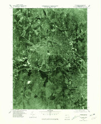 1975 Fitchburg1981 Print · USGSMid-1970s Worcester County comes into focus in this orthophoto, showing the industrial valley of the Nashua River and the growth of Fitchburg. Trace the development of local neighborhoods near Whalom, Waites Corner, and the Notown Reservoir.
 - 1975 Map of Shirley, 1981 Print
 1975 Shirley1981 Print · USGSNorthern Worcester County in the mid-seventies is documented here through high-altitude aerial photography. Trace the rural-to-suburban transition around Lunenburg and the riverbanks of the Nashua River and Squannacook River.
End of results
Showing maps 1-4 of 4
Top cities near Leominster
- Worcester historical maps
- Nashua historical maps
- Fitchburg historical maps
- Marlborough historical maps
- Shrewsbury historical maps
- Gardner historical maps
See more
Top neighborhoods of Leominster
- Gates Crossing historical maps
- West Leominster historical maps
- North Leominster historical maps
- Monument Square Historic District historical maps
Frequently asked questions
- What are the different types of historical maps available for Leominster?
- What is the oldest map of Leominster?
- Where can I purchase historical maps of Leominster for my home or office?
- Where can I download high-res historical maps of Leominster?
- Are there historical topographic maps available for Leominster?
- Is there historical aerial imagery available for Leominster?
- Where are historical maps of Leominster sourced from?