2020s Maps of Kalamazoo, Michigan
Explore 4 historic maps of Kalamazoo from the 2020s. These maps offer a rare glimpse into what life looked like during the 2020s — showing old roads, neighborhoods, homes, and landmarks that have changed or disappeared over time.
Whether you're researching your family's past, planning a metal detecting trip, or studying how Kalamazoo's landscape evolved across the 2020s, these high-resolution maps are a powerful tool for exploring the history of this region.
- Focus on a specific era: All maps on this page are from the 2020s, giving you a focused view of this time period.
- See what’s changed: Compare century-old streets, trails, and buildings to today's modern landscape using overlays and satellite layers.
- Research with precision: Use these maps for genealogy, historical research, land use analysis, or educational projects.
- View, download, or print: Maps are fully viewable online in high resolution, and can be downloaded or printed for your own records.
Start exploring Kalamazoo's history through authentic maps from the 2020s. This is your window into the past.
Kalamazoo, MI maps
(4)- 2023 Map of Kalamazoo SW, 2023 Print
 2023 Kalamazoo SW2023 Print · USGSThe western edges of Kalamazoo and the surrounding rural townships are shown here as they appeared in the early 2020s. Genealogists can locate several historic burial sites, including Hill Cem and Grand Prairie Cem, or trace the path of the Kal-haven Trail State Park Trl.
 - 2023 Map of Schoolcraft NW, 2023 Print
 2023 Schoolcraft NW2023 Print · USGSModern Kalamazoo and Portage sit at the northern edge of this lake-strewn landscape as it appeared recently. Researchers can locate family plots at Hope Cem and Harrison Cem or trace the developing residential corridors around Texas Corners.
 - 2023 Map of Portage, 2023 Print
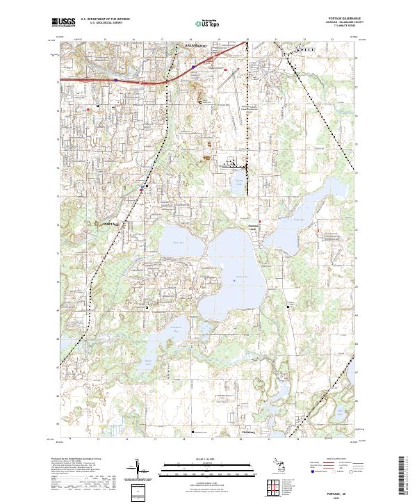 2023 Portage2023 Print · USGSKalamazoo and Portage are seen here in the 2020s, showing a suburban landscape deeply integrated with its historic glacial lakes. Researchers can trace local burial sites at Central Cem or Indian Fields Cem and locate landmarks like Upjohn Pond.
 - 2023 Map of Kalamazoo, 2023 Print
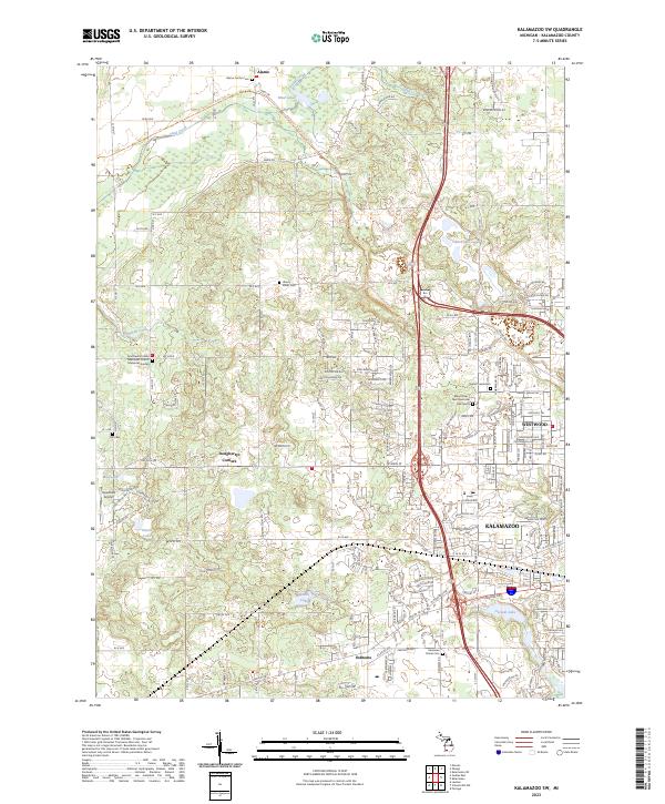
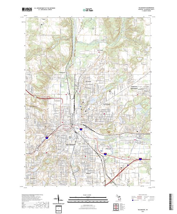 2023 Kalamazoo2023 Print · USGSKalamazoo and its surrounding suburbs are shown in high detail during the early 2020s, capturing the modern layout of this Michigan educational and transit hub. Researchers can trace local heritage through the many sites like Mountain Home Cem, Kalamazoo College, and the industrial Monarch Millpond.
End of results
Showing maps 1-4 of 4
Top cities near Kalamazoo
- Portage historical maps
- Pavilion historical maps
- Alamo historical maps
- Plainwell historical maps
- Otsego historical maps
- Mattawan historical maps
See more
Top neighborhoods of Kalamazoo
Frequently asked questions
- What are the different types of historical maps available for Kalamazoo?
- What is the oldest map of Kalamazoo?
- Where can I purchase historical maps of Kalamazoo for my home or office?
- Where can I download high-res historical maps of Kalamazoo?
- Are there historical topographic maps available for Kalamazoo?
- Is there historical aerial imagery available for Kalamazoo?
- Where are historical maps of Kalamazoo sourced from?