1940s Maps of Macomb County, Michigan
Explore 12 historic maps of Macomb County from the 1940s. These maps offer a rare glimpse into what life looked like during the 1940s — showing old roads, neighborhoods, homes, and landmarks that have changed or disappeared over time.
Whether you're researching your family's past, planning a metal detecting trip, or studying how Macomb County's landscape evolved across the 1940s, these high-resolution maps are a powerful tool for exploring the history of this region.
- Focus on a specific era: All maps on this page are from the 1940s, giving you a focused view of this time period.
- See what’s changed: Compare century-old streets, trails, and buildings to today's modern landscape using overlays and satellite layers.
- Research with precision: Use these maps for genealogy, historical research, land use analysis, or educational projects.
- View, download, or print: Maps are fully viewable online in high resolution, and can be downloaded or printed for your own records.
Start exploring Macomb County's history through authentic maps from the 1940s. This is your window into the past.
Macomb County, MI maps
(12)- 1940 Map of Highland Park
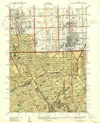 1940 Highland Park1940 Print · USGSGreater Detroit was expanding rapidly just before the war, as residential grids replaced the agricultural lands of southern Macomb and Oakland Counties. Genealogists and historians can locate family landmarks like the Michigan State Fair Grounds and St Clements Cem.2 unique versions available
 - 1940 Map of Grosse Pointe
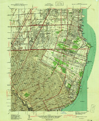 1940 Grosse Pointe1940 Print · USGSCoastal Wayne County and the rising Detroit suburbs are captured here just before the war. Researchers can trace the development of the Pointes and find family landmarks like St Peters Ch, Jefferson Beach, and Gratiot Airport.
 - 1943 Map of Romeo, 1965 Print
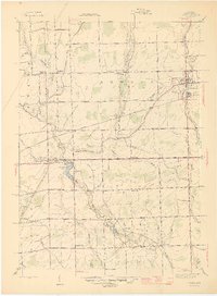
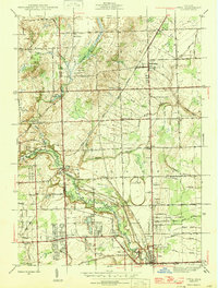
 1943 Romeo1965 Print · USGSNorthern Macomb and Oakland counties are captured during the 1940s, centered on the village of Romeo and its surrounding townships. Researchers can trace the rural school systems at Clifton Sch and Mack Sch or locate the Simpson Park Camp Ground near East Mill Lake.
 - 1944 Map of Memphis
 1944 Memphis1944 Print · USGSSoutheast Michigan farm country is documented here in the 1940s, showing the early crossroads and river-bound settlements of St. Clair and Macomb counties. Genealogists can locate family landmarks like Pound Hill Sch, the village of Riley Center, and the Grand Trunk Western rail line.2 unique versions available
 - 1945 Map of Armada
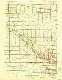
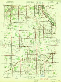
 1945 Armada1945 Print · USGSMacomb County's agricultural heartland is documented here during the mid-forties, centered on the rail-connected village of Armada. Genealogists can locate numerous rural landmarks like Bruce and Armada Cem, Ray Center, and the Bruce and Armada Grange.2 unique versions available
 - 1945 Map of Almont
 1945 Almont1945 Print · USGSAlmont and Dryden are the focal points of this mid-1940s survey of the Lapeer and Macomb county borders during a time of rural schoolhouses and family farms. Researchers can locate many local landmarks like Ferguson Cem, Rider Sch, and Neil Sch along the upper reaches of the Belle River.2 unique versions available
 - 1945 Map of Allenton
 1945 Allenton1945 Print · USGSSt. Clair County's farming heartland is captured here in the mid-1940s, showing a landscape of tight-knit rural communities and school districts. Genealogists can trace family locations near Allenton, Scotch Settlement, and several country schools like Gould Sch and Stoddard Sch.2 unique versions available
 - 1945 Map of Richmond
 1945 Richmond1945 Print · USGSDuring the mid-1940s, Macomb County was a landscape of rail-connected towns and rural townships. Trace family roots through local anchors like Bates Cem, the Zion Ch, and numerous schoolhouses including Hunt Sch and Richards Sch.2 unique versions available
 - 1945 Map of Romeo
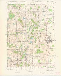
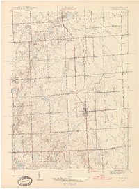
 1945 Romeo1945 Print · USGSNorthern Macomb County comes into focus just after the war, centered on the village of Romeo. Researchers can trace the rural schoolhouse system through Clifton Sch and Sikes Sch, or locate the Clifton Mill along the winding Stony Creek.2 unique versions available
 - 1946 Map of Utica
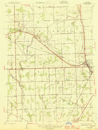
 1946 Utica1946 Print · USGSMacomb and Oakland counties are captured here just after the war as the township of Shelby begins its post-war transition. Genealogists and local historians can trace family roots through numerous country schools like Plain Sch and cemeteries such as Prestonville Cem or Stony Creek Cem.2 unique versions available
 - 1946 Map of Warren
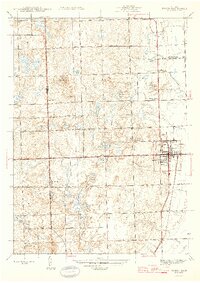
 1946 Warren1946 Print · USGSThe Macomb and Oakland county borderlands are shown here in the mid-1940s, capturing a world of rural schools and early suburban aviation. Genealogists can trace family footprints near the Warren Cem, Big Beaver, and rural schoolhouses like Burr Sch.
 - 1949 Map of St. Clair Flats
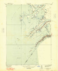 1949 St. Clair Flats1949 Print · USGSThe St. Clair River delta is captured here in the late thirties, showing a labyrinth of marshlands and island settlements. Trace family property and local landmarks along South Channel Rd or explore the early layout of Riverside and The Old Club.2 unique versions available
End of results
Showing maps 1-12 of 12
Top cities of Macomb County
- Sterling Heights historical maps
- Warren historical maps
- Clinton Township historical maps
- Macomb Township historical maps
- Shelby Charter Township historical maps
- Saint Clair Shores historical maps
See more
Frequently asked questions
- What are the different types of historical maps available for Macomb County?
- What is the oldest map of Macomb County?
- Where can I purchase historical maps of Macomb County for my home or office?
- Where can I download high-res historical maps of Macomb County?
- Are there historical topographic maps available for Macomb County?
- Is there historical aerial imagery available for Macomb County?
- Where are historical maps of Macomb County sourced from?