1920s Maps of Macomb County, Michigan
Explore 4 historic maps of Macomb County from the 1920s. These maps offer a rare glimpse into what life looked like during the 1920s — showing old roads, neighborhoods, homes, and landmarks that have changed or disappeared over time.
Whether you're researching your family's past, planning a metal detecting trip, or studying how Macomb County's landscape evolved across the 1920s, these high-resolution maps are a powerful tool for exploring the history of this region.
- Focus on a specific era: All maps on this page are from the 1920s, giving you a focused view of this time period.
- See what’s changed: Compare century-old streets, trails, and buildings to today's modern landscape using overlays and satellite layers.
- Research with precision: Use these maps for genealogy, historical research, land use analysis, or educational projects.
- View, download, or print: Maps are fully viewable online in high resolution, and can be downloaded or printed for your own records.
Start exploring Macomb County's history through authentic maps from the 1920s. This is your window into the past.
Macomb County, MI maps
(4)- 1924 Map of Detroit
 1924 Detroit1924 Print · USGSDetroit and its industrial satellites thrive during the peak of the automotive era. Genealogists and historians can trace the early factory footprints of Dodge Bros. or locate old neighborhood landmarks like Navarre P. O. and Mt. Olivet Cemetery.
 - 1928 Map of Armada
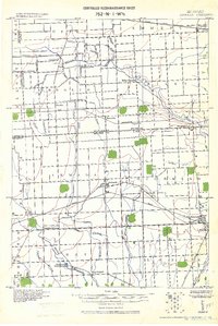 1928 Armada1928 Print · USGSMacomb and St. Clair counties are shown here in the early twentieth century as agriculture and rail travel dominated the landscape. Genealogists can trace family roots through specific locales like Doyle P.O., Sullicks Corners, and the mill at Wolcots Mill Pond.
 - 1928 Map of Hicky
 1928 Hicky1928 Print · USGSSt. Clair County's rural townships and railway hubs are captured here in the years following the Great War. Researchers can locate vanished landmarks and post offices like Lambs P.O. or trace the early paths of the Fort Gratiot Turnpike and Grand Trunk R. R.
 - 1929 Map of Mt Clemens
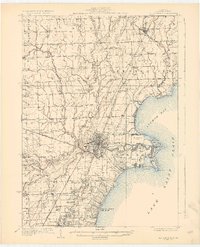 1929 Mt Clemens1929 Print · USGSMacomb County at the end of the twenties shows a landscape of growing towns and early aviation history along the Lake Saint Clair shoreline. Genealogists and historians can trace local landmarks like Selfridge Field, the Grand Trunk Railroad, and numerous parish schools from Fraser to New Haven.4 unique versions available
End of results
Showing maps 1-4 of 4
Top cities of Macomb County
- Sterling Heights historical maps
- Warren historical maps
- Clinton Township historical maps
- Macomb Township historical maps
- Shelby Charter Township historical maps
- Saint Clair Shores historical maps
See more
Frequently asked questions
- What are the different types of historical maps available for Macomb County?
- What is the oldest map of Macomb County?
- Where can I purchase historical maps of Macomb County for my home or office?
- Where can I download high-res historical maps of Macomb County?
- Are there historical topographic maps available for Macomb County?
- Is there historical aerial imagery available for Macomb County?
- Where are historical maps of Macomb County sourced from?