1910s Maps of Macomb County, Michigan
Explore 5 historic maps of Macomb County from the 1910s. These maps offer a rare glimpse into what life looked like during the 1910s — showing old roads, neighborhoods, homes, and landmarks that have changed or disappeared over time.
Whether you're researching your family's past, planning a metal detecting trip, or studying how Macomb County's landscape evolved across the 1910s, these high-resolution maps are a powerful tool for exploring the history of this region.
- Focus on a specific era: All maps on this page are from the 1910s, giving you a focused view of this time period.
- See what’s changed: Compare century-old streets, trails, and buildings to today's modern landscape using overlays and satellite layers.
- Research with precision: Use these maps for genealogy, historical research, land use analysis, or educational projects.
- View, download, or print: Maps are fully viewable online in high resolution, and can be downloaded or printed for your own records.
Start exploring Macomb County's history through authentic maps from the 1910s. This is your window into the past.
Macomb County, MI maps
(5)- 1912 Map of Mt Clemens
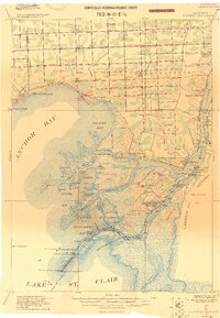
 1912 Mt Clemens1912 Print · USGSMacomb County at the dawn of the aviation age shows a landscape shaped by the winding Clinton River and the arrival of Selfridge Aviation Field. Genealogists and historians can locate legacy settlements like Waldenburg and early industrial sites like the Macomb Sugar Factory.
 - 1914 Map of Armada
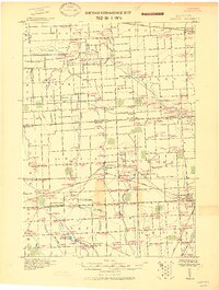 1914 Armada1914 Print · USGSMacomb and St. Clair Counties are seen here in the years before the Great War as a productive agricultural landscape tied together by rail. Researchers can trace historic farmstead locations and early rural infrastructure, from Wolcotts Mill Pond to the busy Grand Trunk R. R. junctions at Armada and Richmond.
 - 1914 Map of Algonac
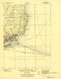
 1914 Algonac1914 Print · USGSThe St. Clair River delta and Harsens Island are captured here before the mid-century shoreline changes. Genealogists can locate family holdings near Starrville or trace the early waterfront developments of Sans Souci P.O. and Tashmoo Park.
 - 1918 Map of Detroit
 1918 Detroit1918 Print · USGSDetroit and its surrounding townships appear at the height of the early industrial era, captured just after the close of the Great War. Local researchers can trace the growth of the Ford Motor Co. empire near Navarre P.O. and explore the historic rail corridors of Hamtramck and Royal Oak.
 - 1918 Map of Grosse Pointe
 1918 Grosse Pointe1918 Print · USGSThe Lake St. Clair shoreline comes alive in this late-era survey of Wayne and Macomb counties, showing the region just as the Grosse Pointes were formalizing. Trace early electric transit via the Detroit and Port Huron Electric Line and locate vanished stops at Labadies or Claireview.
End of results
Showing maps 1-5 of 5
Top cities of Macomb County
- Sterling Heights historical maps
- Warren historical maps
- Clinton Township historical maps
- Macomb Township historical maps
- Shelby Charter Township historical maps
- Saint Clair Shores historical maps
See more
Frequently asked questions
- What are the different types of historical maps available for Macomb County?
- What is the oldest map of Macomb County?
- Where can I purchase historical maps of Macomb County for my home or office?
- Where can I download high-res historical maps of Macomb County?
- Are there historical topographic maps available for Macomb County?
- Is there historical aerial imagery available for Macomb County?
- Where are historical maps of Macomb County sourced from?