1930s Maps of Erie Township, Michigan
Explore 7 historic maps of Erie Township from the 1930s. These maps offer a rare glimpse into what life looked like during the 1930s — showing old roads, neighborhoods, homes, and landmarks that have changed or disappeared over time.
Whether you're researching your family's past, planning a metal detecting trip, or studying how Erie Township's landscape evolved across the 1930s, these high-resolution maps are a powerful tool for exploring the history of this region.
- Focus on a specific era: All maps on this page are from the 1930s, giving you a focused view of this time period.
- See what’s changed: Compare century-old streets, trails, and buildings to today's modern landscape using overlays and satellite layers.
- Research with precision: Use these maps for genealogy, historical research, land use analysis, or educational projects.
- View, download, or print: Maps are fully viewable online in high resolution, and can be downloaded or printed for your own records.
Start exploring Erie Township's history through authentic maps from the 1930s. This is your window into the past.
Erie Township, MI maps
(7)- 1934 Map of Point Place
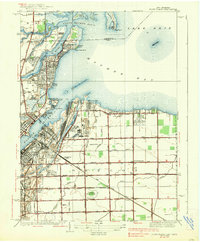
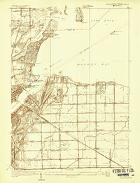 1934 Point Place1934 Print · USGSThe Lake Erie shoreline near Toledo comes to life in the mid-1930s, showing a landscape defined by maritime trade and residential growth. Genealogists and historians can trace family locations near Point Place, Momineetown, and landmarks like the Toledo Yacht Club.
 - 1936 Map of Samaria
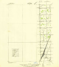 1936 Samaria1936 Print · USGSDuring the mid-1930s, this corridor north of the Michigan-Ohio border was a hub of drainage projects and rail expansion. Researchers can trace the layout of the Ottawa Yard, the site of Vienna Junction, and local landmarks like Erie Union Cem and Yargerville Sch.
 - 1936 Map of Erie
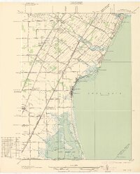 1936 Erie1936 Print · USGSCoastal Monroe County in the mid-1930s shows a landscape of lakeside resorts and busy rail corridors heading toward the Ohio line. Genealogists and local historians can locate early twentieth-century landmarks like San Freal Sch, Luna Pier, and the Roselawn Memorial Cem.
 - 1938 Map of Toledo
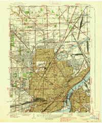 1938 Toledo1938 Print · USGSIn the late thirties, this industrial hub was defined by the confluence of the Maumee River and an immense railroad network. Genealogists and historians can trace the early layout of Toledo University, numerous family cemeteries like Southard Cem, and rail landmarks including Air Line Junction.2 unique versions available
 - 1938 Map of Point Place
 1938 Point Place1938 Print · USGSCoastal life and heavy industry intersect along Maumee Bay in the late thirties as the region’s rail and maritime networks expanded. Researchers can trace the heritage of Point Place, the waterfront Naval Armory, and rural settlements like Momeneetown and Booth.2 unique versions available
 - 1939 Map of Samaria, 1959 Print
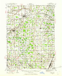
 1939 Samaria1959 Print · USGSMonroe County farmland and early transport corridors are documented here just before the 1940s. Genealogists and local historians can trace family roots through Zion Ch, St Joseph Cem, and vanished schoolhouses like Dean Sch.
 - 1939 Map of Dundee, 1961 Print
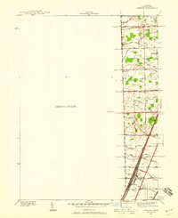
 1939 Dundee1961 Print · USGSMonroe County before the war was a landscape of river-bend towns and rural school districts linked by an intricate rail and water network. Genealogists can locate family landmarks such as St Anthonys Ch, Wells Sch, and numerous burial grounds like Oak Grove Cem.2 unique versions available
End of results
Showing maps 1-7 of 7
Top cities near Erie Township
- Toledo historical maps
- Bedford Township historical maps
- Perrysburg historical maps
- Frenchtown Charter Township historical maps
- Monroe historical maps
- Oregon historical maps
See more
Top neighborhoods of Erie Township
Frequently asked questions
- What are the different types of historical maps available for Erie Township?
- What is the oldest map of Erie Township?
- Where can I purchase historical maps of Erie Township for my home or office?
- Where can I download high-res historical maps of Erie Township?
- Are there historical topographic maps available for Erie Township?
- Is there historical aerial imagery available for Erie Township?
- Where are historical maps of Erie Township sourced from?