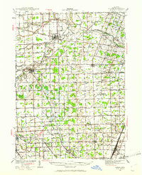
1939 Map of Dundee
USGS Topo · Published 1961About this map
The River Raisin and its numerous branches dominate this agricultural landscape in Monroe County, flowing toward the western edge of Lake Erie. In the late 1930s, the area was defined by a dense network of rural schoolhouses such as Egypt Sch, Heck Sch, and Stony Ridge Sch, reflecting a time before district consolidation. The town of Dundee sits at a strategic bend in the river, while Petersburg Junction serves as a nexus for the region's rail activity.
Find a feature on this map
104 named features on this map. Tap any name to fly to it.
Don’t see what you’re looking for? This feature index may not catch every label — zoom into the map to look around manually.
Map Details
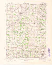
Editions of this 1939 Dundee Map
2 editions found
Other maps of this area

1900 · Maumee Bay
USGS Topo · 1:62,500

1900 · Toledo
USGS Topo · 1:62,500

1902 · Ypsilanti
USGS Topo · 1:62,500

1904 · Ann Arbor
USGS Topo · 1:125,000

1906 · Ypsilanti
USGS Topo · 1:62,500

1906 · Saline
USGS Topo · 1:62,500

1906 · Romulus
USGS Topo · 1:62,500

1908 · Ann Arbor
USGS Topo · 1:125,000

1911 · Swanton
USGS Topo · 1:62,500

1912 · Monroe
USGS Topo · 1:62,500
Featured Places
- Bedford Township, MI
- Lambertville, Bedford Township
- Temperance, Bedford Township
- Raisinville Township, MI
- Ida, Ida Township