1950s Maps of Carp Lake Township, Michigan
Explore 10 historic maps of Carp Lake Township from the 1950s. These maps offer a rare glimpse into what life looked like during the 1950s — showing old roads, neighborhoods, homes, and landmarks that have changed or disappeared over time.
Whether you're researching your family's past, planning a metal detecting trip, or studying how Carp Lake Township's landscape evolved across the 1950s, these high-resolution maps are a powerful tool for exploring the history of this region.
- Focus on a specific era: All maps on this page are from the 1950s, giving you a focused view of this time period.
- See what’s changed: Compare century-old streets, trails, and buildings to today's modern landscape using overlays and satellite layers.
- Research with precision: Use these maps for genealogy, historical research, land use analysis, or educational projects.
- View, download, or print: Maps are fully viewable online in high resolution, and can be downloaded or printed for your own records.
Start exploring Carp Lake Township's history through authentic maps from the 1950s. This is your window into the past.
Carp Lake Township, MI maps
(10)- 1955 Map of Ontonagon, 1956 Print
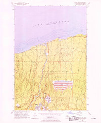
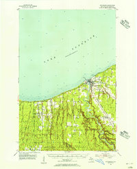 1955 Ontonagon1956 Print · USGSThe Lake Superior shoreline and the Ontonagon River mouth define this mid-century look at Michigan's Copper Country. Trace old transport routes and industry at Wood Spur, locate the Lighthouse, or find family names near Riverside Cem.2 unique versions available
 - 1956 Map of Carp River, 1957 Print
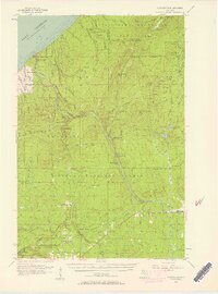
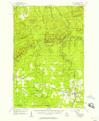
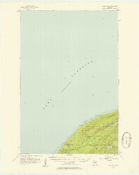 1956 Carp River1957 Print · USGSThe Upper Peninsula shoreline meets the high ridges of the western Gogebic Range in the mid-1950s. Trace old mining sites like the LaFayette Mine and backcountry landmarks including Lake of the Clouds, Mirror Lake, and Lone Rock.4 unique versions available
 - 1956 Map of Bergland NE, 1957 Print
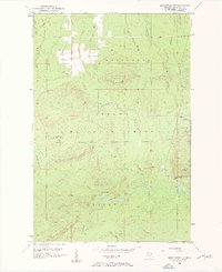
 1956 Bergland NE1957 Print · USGSOntonagon County in the mid-fifties is seen here during a period of active copper mining and forest management. Researchers can trace the industrial footprint of the White Pine Mine, the Bergland Lookout Tower, and the local Old Railroad Grade.2 unique versions available
 - 1956 Map of Bergland, 1957 Print
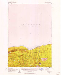
 1956 Bergland1957 Print · USGSUpper Peninsula timber and copper country come into focus in the mid-fifties as the railroad meets the shores of Lake Gogebic. Researchers can trace the rail sidings near Bergland, the workings of the White Pine Mine, and remote landmarks like Krobath Cabin.3 unique versions available
 - 1956 Map of Thomaston, 1957 Print
 1956 Thomaston1957 Print · USGSThe Upper Peninsula wilderness in the mid-fifties is captured here, showing the heavy industrial influence of the Chicago and North Western railroad. Researchers can trace the timber-era rail sidings at Tula and Manley Siding or locate the Underwood Lookout Tower.4 unique versions available
 - 1956 Map of White Pine, 1958 Print
 1956 White Pine1958 Print · USGSThe copper-rich shores of Lake Superior are shown here during a period of significant industrial activity in the mid-1950s. You can trace the extensive operations at the White Pine Mine, locate the historic settlement of Nonesuch, and follow the D S S & A rail line through the Ottawa National Forest.3 unique versions available
 - 1956 Map of Matchwood NW, 1958 Print
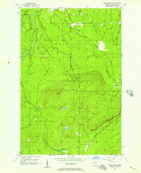
 1956 Matchwood NW1958 Print · USGSThe Upper Peninsula wilderness of the mid-fifties is captured here, showing the intersection of heavy industry and the Ottawa National Forest. Researchers can locate the Norwich Mine and trace the path of an Old Railroad Grade.3 unique versions available
 - 1956 Map of White Pine, 1958 Print
 1956 White Pine1958 Print · USGSCopper mining and rugged shoreline topography define the Ontonagon coast in the mid-fifties. Researchers can trace industrial developments like the White Pine Mine and Tailings Pond alongside landmarks like Lake of the Clouds.3 unique versions available
 - 1956 Map of Matchwood, 1958 Print
 1956 Matchwood1958 Print · USGSOntonagon County thrived as a railroad and timber hub in the mid-fifties, centered around the Duluth South Shore and Atlantic line. Local historians and genealogists can trace the settlements of Topaz and Ewen, locate the Norwich Mine, and find family sites near the Ewen Cem.2 unique versions available
 - 1958 Map of Iron River, 1968 Print
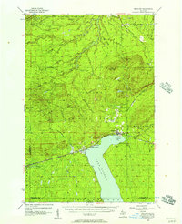
 1958 Iron River1968 Print · USGSThe Upper Peninsula in the late fifties is captured here as a landscape of timber, iron, and rail. Genealogists and historians can trace rail stops like Mass Station or explore the coastlines of Lake Gogebic and Keweenaw Bay.3 unique versions available
End of results
Showing maps 1-10 of 10
Top cities near Carp Lake Township
Top neighborhoods of Carp Lake Township
Frequently asked questions
- What are the different types of historical maps available for Carp Lake Township?
- What is the oldest map of Carp Lake Township?
- Where can I purchase historical maps of Carp Lake Township for my home or office?
- Where can I download high-res historical maps of Carp Lake Township?
- Are there historical topographic maps available for Carp Lake Township?
- Is there historical aerial imagery available for Carp Lake Township?
- Where are historical maps of Carp Lake Township sourced from?