1930s Maps of Van Buren County, Michigan
Explore 4 historic maps of Van Buren County from the 1930s. These maps offer a rare glimpse into what life looked like during the 1930s — showing old roads, neighborhoods, homes, and landmarks that have changed or disappeared over time.
Whether you're researching your family's past, planning a metal detecting trip, or studying how Van Buren County's landscape evolved across the 1930s, these high-resolution maps are a powerful tool for exploring the history of this region.
- Focus on a specific era: All maps on this page are from the 1930s, giving you a focused view of this time period.
- See what’s changed: Compare century-old streets, trails, and buildings to today's modern landscape using overlays and satellite layers.
- Research with precision: Use these maps for genealogy, historical research, land use analysis, or educational projects.
- View, download, or print: Maps are fully viewable online in high resolution, and can be downloaded or printed for your own records.
Start exploring Van Buren County's history through authentic maps from the 1930s. This is your window into the past.
Van Buren County, MI maps
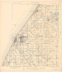
(4)- 1930 Map of South Haven
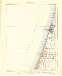 1930 South Haven1930 Print · USGSSouthwest Michigan's lakeshore comes alive in this early Depression-era survey, showing the bustling port of South Haven and its surrounding resort beaches. Genealogists and local historians can trace rural school districts like Fish Sch and landmarks such as the Emanuel Home and Thunder Mtn.4 unique versions available
 - 1930 Map of Benton Harbor
 1930 Benton Harbor1930 Print · USGSBerrien County's lakefront and river valleys appear in high detail during the late Prohibition era. Genealogists can trace family names through dozens of rural landmarks like Twelve Corners, Crystal Springs Cem, and the House of David.4 unique versions available
 - 1931 Map of Bangor
 1931 Bangor1931 Print · USGSCoastal resorts and interior farmsteads meet in this early 1930s survey of the Michigan lakefront and the Black River basin. Researchers can trace the PERE MARQUETTE rail line through Grand Junction or locate family sites like Kibbie Chapel and Gardner of Eden Sch.3 unique versions available
 - 1931 Map of Hartford
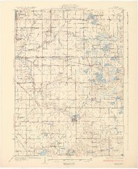
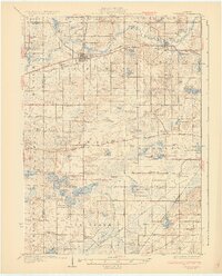 1931 Hartford1931 Print · USGSVan Buren County and the northern edge of Cass County appear here in the late twenties, defined by a dense landscape of glacial lakes and river bottomlands. Researchers can locate early country schools like Brague Sch, the Red Mill on Silver Creek, and historic crossroads including Keeler and Fritzburg.2 unique versions available
End of results
Showing maps 1-4 of 4
Top cities of Van Buren County
Frequently asked questions
- What are the different types of historical maps available for Van Buren County?
- What is the oldest map of Van Buren County?
- Where can I purchase historical maps of Van Buren County for my home or office?
- Where can I download high-res historical maps of Van Buren County?
- Are there historical topographic maps available for Van Buren County?
- Is there historical aerial imagery available for Van Buren County?
- Where are historical maps of Van Buren County sourced from?