1910s Maps of Koochiching County, Minnesota
Explore 13 historic maps of Koochiching County from the 1910s. These maps offer a rare glimpse into what life looked like during the 1910s — showing old roads, neighborhoods, homes, and landmarks that have changed or disappeared over time.
Whether you're researching your family's past, planning a metal detecting trip, or studying how Koochiching County's landscape evolved across the 1910s, these high-resolution maps are a powerful tool for exploring the history of this region.
- Focus on a specific era: All maps on this page are from the 1910s, giving you a focused view of this time period.
- See what’s changed: Compare century-old streets, trails, and buildings to today's modern landscape using overlays and satellite layers.
- Research with precision: Use these maps for genealogy, historical research, land use analysis, or educational projects.
- View, download, or print: Maps are fully viewable online in high resolution, and can be downloaded or printed for your own records.
Start exploring Koochiching County's history through authentic maps from the 1910s. This is your window into the past.
Koochiching County, MN maps
(13)- 1918 Map of Zora, 1943 Print
 1918 Zora1943 Print · USGSNorthern Minnesota's riverfront and wetlands are documented here in the early twentieth century as drainage projects began to reshape the woods. Researchers can trace the winding Big Fork River and locate early landmarks like Caldwell and the Judicial Ditch.
 - 1919 Map of Zora
 1919 Zora1919 Print · USGSNorthern Minnesota during the early years of the twentieth century was a landscape of remote timberlands and new county lines. Genealogists and local historians can trace the small settlement of Caldwell and early infrastructure like Judicial Ditch and the Big Fork River.
 - 1919 Map of Lundgren
 1919 Lundgren1919 Print · USGSNorthern Minnesota's wetland frontier is captured here at the end of the Great War, showing a landscape defined by drainage ditches and early rail lines. Researchers can trace the Minnesota and International railroad and find early settlements like Lundgren, Evergreen, and Wicker.2 unique versions available
 - 1919 Map of Gemmell
 1919 Gemmell1919 Print · USGSNorthern Minnesota’s timber and rail landscape is caught here just after the Great War. Genealogists and rail historians can trace the Minnesota and International Ry corridor through Gemmell and Mizpah, or locate the isolated School near Pine Top.
 - 1919 Map of Norden
 1919 Norden1919 Print · USGSNorthern Minnesota’s drainage and timber frontier is captured here just after the Great War. Genealogists and researchers can trace the early township lines of Washkish and Norden alongside the historic Old Red Lake Indian Reservation Boundary.
 - 1919 Map of Pelland
 1919 Pelland1919 Print · USGSKoochiching County sits at the edge of the international border in 1919, where river traffic and rail transport defined the local economy. Genealogists and historians can trace the early layouts of Pelland, Big Fork, and Laurel along the path of the Minnesota Dakota and Western railroad.2 unique versions available
 - 1919 Map of Birchdale
 1919 Birchdale1919 Print · USGSThe Rainy River borderlands come to life in this post-World War I military survey, showing the early infrastructure of northern Koochiching County. Researchers can trace the development of Birchdale and Manitou and follow the intricate Judicial Ditch drainage system.
 - 1919 Map of I
 1919 I1919 Print · USGSKoochiching County at the end of the Great War was a frontier of timber and tribal boundaries. Researchers can trace the legacy of land division through the Original Red Lake Indian Reservation Boundary and the settlement at Fairland.
 - 1919 Map of Bridgie, 1924 Print
 1919 Bridgie1924 Print · USGSNorthern Minnesota timber country comes alive in this post-World War I era survey of the borderlands between Beltrami and Koochiching counties. Genealogists and historians can trace the early railroad boom through Northome, Funkley, and Orth along the Minnesota International line.
 - 1919 Map of Happy Land, 1943 Print
 1919 Happy Land1943 Print · USGSKoochiching County at the close of the Great War shows a wilderness being transformed by an ambitious network of drainage ditches and rail lines. Genealogists can trace family-named sites and vanished stops like Happyland, Bessemer, and the station at Wisner.
 - 1919 Map of M, 1943 Print
 1919 M1943 Print · USGSKoochiching County at the close of the frontier era reveals a northern wilderness being reshaped by drainage projects and early rail. Genealogists and local historians can trace the early footprints of McDonald, Dentaybow, and Rockton along the winding Big Fork River.
 - 1919 Map of Margie, 1943 Print
 1919 Margie1943 Print · USGSKoochiching County as the railroad era opened up the northern woods, showing a landscape of river bends and newly cut drainage ditches. Trace early timber and rail history through the settlements at Big Falls, Grand Falls, and the remote station at Margie.
 - 1919 Map of International Falls, 1943 Print
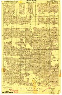
 1919 International Falls1943 Print · USGSInternational Falls and the Canadian border are captured in the era of early industrial expansion. Researchers can trace the development of neighborhood additions and remote rail stops like Goldville, Nakoda, and the local Poor Farm along the Rainy River.
End of results
Showing maps 1-13 of 13
Top cities of Koochiching County
- International Falls historical maps
- Littlefork historical maps
- Big Falls historical maps
- Northome historical maps
- Ranier historical maps
- Mizpah historical maps
Frequently asked questions
- What are the different types of historical maps available for Koochiching County?
- What is the oldest map of Koochiching County?
- Where can I purchase historical maps of Koochiching County for my home or office?
- Where can I download high-res historical maps of Koochiching County?
- Are there historical topographic maps available for Koochiching County?
- Is there historical aerial imagery available for Koochiching County?
- Where are historical maps of Koochiching County sourced from?