1960s Maps of Koochiching County, Minnesota
Explore 24 historic maps of Koochiching County from the 1960s. These maps offer a rare glimpse into what life looked like during the 1960s — showing old roads, neighborhoods, homes, and landmarks that have changed or disappeared over time.
Whether you're researching your family's past, planning a metal detecting trip, or studying how Koochiching County's landscape evolved across the 1960s, these high-resolution maps are a powerful tool for exploring the history of this region.
- Focus on a specific era: All maps on this page are from the 1960s, giving you a focused view of this time period.
- See what’s changed: Compare century-old streets, trails, and buildings to today's modern landscape using overlays and satellite layers.
- Research with precision: Use these maps for genealogy, historical research, land use analysis, or educational projects.
- View, download, or print: Maps are fully viewable online in high resolution, and can be downloaded or printed for your own records.
Start exploring Koochiching County's history through authentic maps from the 1960s. This is your window into the past.
Koochiching County, MN maps
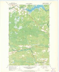
(24)- 1963 Map of Ranier, 1987 Print
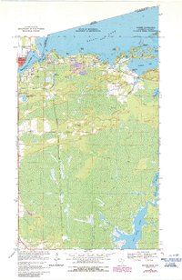 1963 Ranier1987 Print · USGSThe international border at Ranier and Fort Frances was a critical rail and river hub in the mid-to-late twentieth century. Local historians can trace the paths of the Canadian National railroad and identify landmarks like Point-O-Pines Ch and Falls Junction.
 - 1964 Map of Hibbing
 1964 Hibbing1964 Print · USGSNorthern Minnesota’s iron-rich corridor is captured here during a peak era of mid-century industrial activity. Researchers can trace the rail-to-mine connections through Mesabi Range towns like Hibbing and Virginia or locate lakefront settlements near Pokegama Lake.
 - 1968 Map of Clementson, 1970 Print
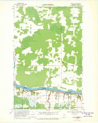
 1968 Clementson1970 Print · USGSThe border country along the Rainy River comes alive in the late sixties, showing the vital connection between water and settlement. Genealogists can trace family sites at Silver Creek Cem or follow the path of the CANADIAN NATIONAL rail line.
 - 1968 Map of Birchdale SW, 1970 Print
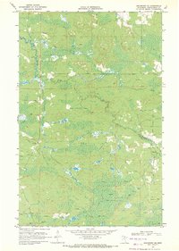
 1968 Birchdale SW1970 Print · USGSNorthern Minnesota's boggy wilderness is captured here in the late sixties, showing the vast transition from forest to marshland. Researchers can trace the path of the Winter Trail through the Red Lake Indian Reservation and locate the remote Lost Lake.2 unique versions available
 - 1968 Map of Birchdale SE, 1970 Print
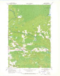
 1968 Birchdale SE1970 Print · USGSThe Koochiching County wilderness in the late sixties reveals a landscape shaped by seasonal logging and isolation. Researchers can trace the extensive network of the Winter Trail and locate landmarks like Lost Lake and the West Fork Black River.
 - 1968 Map of Stratton, 1970 Print
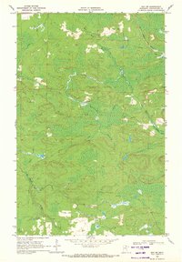
 1968 Stratton1970 Print · USGSThe international border along the Rainy River is captured here in the late sixties, showing the transition from Minnesota forest to Ontario rail corridor. Local historians can trace the Canadian National line through Stratton and locate early sites like the Gravel Pit and Pine Island State Forest.2 unique versions available
 - 1968 Map of Birchdale, 1970 Print
 1968 Birchdale1970 Print · USGSThe international border along the Rainy River comes to life in the late 1960s, showing the intersection of rail, river, and remote settlement. Genealogists and historians can trace the community of Birchdale, the Birchdale Cem, and the path of the Canadian National railway.
 - 1968 Map of Border, 1970 Print
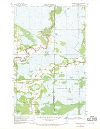
 1968 Border1970 Print · USGSThe international border along the Rainy River comes into focus during the late sixties, showing the isolated communities of northern Koochiching County. Researchers can trace local history at Riverdale Cem or follow the route of the Canadian National rail line past Border and Frontier.
 - 1968 Map of Clementson SW, 1970 Print
 1968 Clementson SW1970 Print · USGSNorthern Minnesota's river systems and tribal lands are meticulously detailed in the late 1960s. Genealogists and historians can trace the meandering Rapid River and locate the settlement at Bartons within the Red Lake Indian Reservation.
 - 1968 Map of Clementson SE, 1970 Print
 1968 Clementson SE1970 Print · USGSKoochiching County was a land of timber and seasonal trails in the late sixties, where the forest floor gave way to extensive marshlands. Researchers can trace the winding Wing River and the path of the Winter Trail through the Pine Island State Forest.
 - 1969 Map of Ray SE, 1971 Print
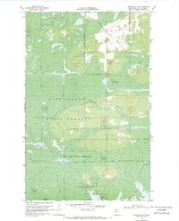
 1969 Ray SE1971 Print · USGSThe northern timberlands of St. Louis County are captured here in the late sixties, showing a landscape defined by rail corridors and state forest. Researchers can trace the Duluth Winnipeg and Pacific line to Arbutus or locate the Kabetogama Lookout Tower and Pearl Lake.2 unique versions available
 - 1969 Map of Island View, 1971 Print
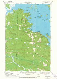
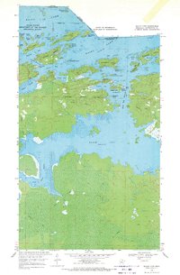 1969 Island View1971 Print · USGSRainy Lake and the Canadian border define this northern Minnesota landscape in the late sixties. Explore the intricate island geography from Little American Island to Dryweed Island, or trace the network of Winter Trails and the settlement at Island View.4 unique versions available
 - 1969 Map of Ericsburg NW, 1971 Print
 1969 Ericsburg NW1971 Print · USGSNorthern Minnesota's wetland interior is documented here during the late sixties, showing the vital role of seasonal transportation. Researchers can trace the Burlington Northern rail line and the extensive Winter Trail passing by Moose Lake.2 unique versions available
 - 1969 Map of Nett Lake, 1971 Print
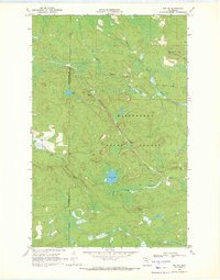
 1969 Nett Lake1971 Print · USGSNett Lake and the surrounding wilderness of St. Louis County are captured here in the late sixties, showing a landscape defined by water and winter transit. Researchers can trace the Nett Lake Ranger Station, the Heritage Lookout Tower, and an extensive network of Winter Trails.2 unique versions available
 - 1969 Map of Ericsburg, 1971 Print
 1969 Ericsburg1971 Print · USGSThe northern Minnesota border country comes to life in the late 1960s, showing the intersection of heavy rail and wild waterways. Trace the path of the Duluth Winnipeg and Pacific railroad as it passes through Ericsburg and across the Rat Root River.2 unique versions available
 - 1969 Map of Ericsburg SE, 1971 Print
 1969 Ericsburg SE1971 Print · USGSKoochiching County’s northern woods and marshlands are captured here in the late sixties, a landscape defined by seasonal transit. Researchers can trace the extensive network of Winter Trails and find localized landmarks like the Flowing Well and Beaver Brook.2 unique versions available
 - 1969 Map of Ray, 1971 Print
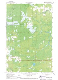
 1969 Ray1971 Print · USGSNorthern Minnesota forest lands and small-town life are documented here in the late sixties, centered on the railroad town of Ray. Genealogists can locate Ray Cem and Lyman Cem, while the Duluth Winnipeg and Pacific line marks the local economy.4 unique versions available
 - 1969 Map of Ray SW, 1971 Print
 1969 Ray SW1971 Print · USGSNorthern Minnesota's timber and bog country is captured here during the late sixties, highlighting a landscape shaped by seasonal access. Trace the path of the Duluth Winnipeg and Pacific rail line and the specialized Winter Trail network near the Rat Root River.2 unique versions available
 - 1969 Map of Cranberry Bay, 1971 Print
 1969 Cranberry Bay1971 Print · USGSThe remote Minnesota-Ontario borderlands are shown here in the late sixties, where water and forest define the landscape. Trace early portages and seasonal paths like the Gold Portage Trail or find local landmarks such as Cemetery Island and the Chief Wooden Frogs Islands.3 unique versions available
 - 1969 Map of Ranier, 1971 Print
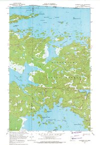
 1969 Ranier1971 Print · USGSThe northern borderlands around the turn of the 1970s reveal a busy rail and river crossroads where the United States meets Canada. Trace the industrial footprint of Falls Junction and the lakefront docks of Ranier alongside local landmarks like Point-O-Pines Ch.2 unique versions available
 - 1969 Map of Ericsburg SW, 1971 Print
 1969 Ericsburg SW1971 Print · USGSIn the late 1960s, this Koochiching County wilderness was defined by the winding Little Fork River and seasonal access routes. Researchers can trace the path of several Winter Trails and locate numerous Gravel Pits along the river's edge.
 - 1969 Map of Kabetogama, 1971 Print
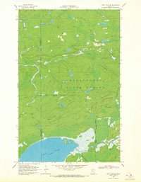
 1969 Kabetogama1971 Print · USGSThe northern lake country of St. Louis and Koochiching Counties is captured here in the late sixties as a thriving frontier of timber and recreation. Researchers can locate remote camps and landings such as Chief Wooden Frog Campground, St Jude Chapel, and Sugarbush Island.3 unique versions available
 - 1969 Map of Nett Lake NE, 1971 Print
 1969 Nett Lake NE1971 Print · USGSNorthern Minnesota's woods and waterways are captured in the late sixties, highlighting the intersection of the Nett Lake Indian Reservation and Kabetogama State Forest. Researchers can trace the Lost River and a network of Winter Trails through the marshes.2 unique versions available
 - 1969 Map of International Falls, 1972 Print
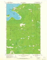
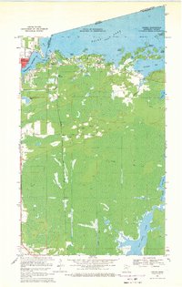
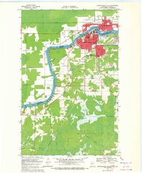 1969 International Falls1972 Print · USGSThe twin border towns of Fort Frances and International Falls are captured here during the late sixties. Researchers can trace the era's infrastructure from the US Customs station to local schools like Holler Sch and Forestland Sch.2 unique versions available
End of results
Showing maps 1-24 of 24
Top cities of Koochiching County
- International Falls historical maps
- Littlefork historical maps
- Big Falls historical maps
- Northome historical maps
- Ranier historical maps
- Mizpah historical maps
Frequently asked questions
- What are the different types of historical maps available for Koochiching County?
- What is the oldest map of Koochiching County?
- Where can I purchase historical maps of Koochiching County for my home or office?
- Where can I download high-res historical maps of Koochiching County?
- Are there historical topographic maps available for Koochiching County?
- Is there historical aerial imagery available for Koochiching County?
- Where are historical maps of Koochiching County sourced from?