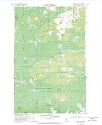
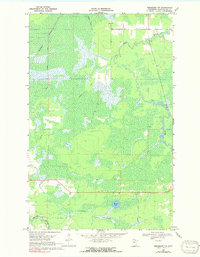
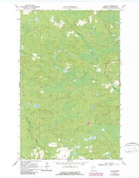
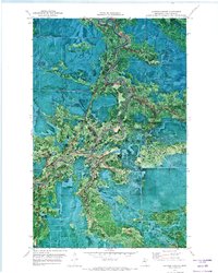
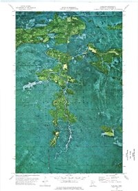
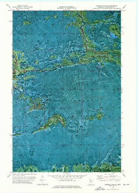
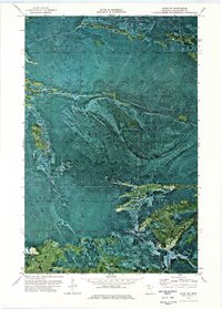
1968 Map of Birchdale SW
USGS Topo · Published 1970This historical map portrays the area of Birchdale SW in 1968, primarily covering Koochiching County. Featuring a scale of 1:24000, this map provides a highly detailed snapshot of the terrain, roads, buildings, counties, and historical landmarks in the Birchdale SW region at the time. Published in 1970, it is one of 2 known editions of this map due to revisions or reprints.
Find a feature on this map
11 named features on this map. Tap any name to fly to it.
Don’t see what you’re looking for? This feature index may not catch every label — zoom into the map to look around manually.
Map Details
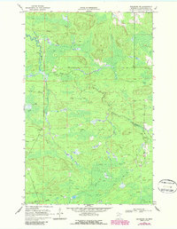
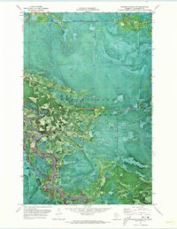
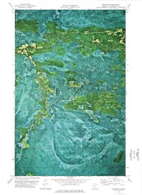
Editions of this 1968 Birchdale SW Map
2 editions found
Historical Maps of Koochiching County Through Time
77 maps found

1918 Zora
Koochiching County, MN

1919 Birchdale
Koochiching County, MN

1919 Bridgie
Koochiching County, MN

1919 Gemmell
Koochiching County, MN

1919 Happy Land
Koochiching County, MN

1919 I
Koochiching County, MN

1919 Lundgren
Koochiching County, MN

1919 Margie
Koochiching County, MN

1919 M
Koochiching County, MN

1919 Norden
Koochiching County, MN

1919 Pelland
Koochiching County, MN

1919 Zora
Koochiching County, MN

1924 Bridgie
Koochiching County, MN

1943 Lindford
Koochiching County, MN

1968 Birchdale
Koochiching County, MN

1968 Birchdale SE
Koochiching County, MN
1968 Birchdale SW
Koochiching County, MN

1968 Border
Koochiching County, MN

1968 Clementson SE
Koochiching County, MN
1968 Stratton
Koochiching County, MN
1969 Ericsburg
Koochiching County, MN
1969 Ericsburg NW
Koochiching County, MN
1969 Ericsburg SE
Koochiching County, MN

1969 Ericsburg SW
Koochiching County, MN
1969 Island View
Koochiching County, MN
1969 Ray
Koochiching County, MN
1969 Ray SW
Koochiching County, MN

1970 Big Falls SE
Koochiching County, MN

1970 Deer Lake NE
Koochiching County, MN

1970 Deer Lake NW
Koochiching County, MN

1970 Devlin
Koochiching County, MN

1970 Johnson Landing NE
Koochiching County, MN

1970 Johnson Landing SE
Koochiching County, MN

1970 Lindford
Koochiching County, MN

1970 Lindford NW
Koochiching County, MN

1970 Lindford SE
Koochiching County, MN

1970 Lindford SW
Koochiching County, MN

1970 Littlefork NW
Koochiching County, MN

1970 Littlefork SE
Koochiching County, MN

1970 Littlefork SW
Koochiching County, MN

1970 Loman
Koochiching County, MN

1970 Manitou
Koochiching County, MN

1970 Margie
Koochiching County, MN

1970 Nett Lake NW
Koochiching County, MN

1970 Nett Lake River East
Koochiching County, MN

1970 Nett Lake River SE
Koochiching County, MN
1970 Nett Lake River SW
Koochiching County, MN

1970 Nett Lake River West
Koochiching County, MN

1970 Nett Lake SW
Koochiching County, MN

1970 Pelland
Koochiching County, MN

1970 Rauch
Koochiching County, MN

1971 Big Falls NW
Koochiching County, MN
1971 Craigville
Koochiching County, MN
1971 Effie NW
Koochiching County, MN
1971 Johnson Landing
Koochiching County, MN
1971 Johnson Landing NW
Koochiching County, MN
1971 Mizpah NE
Koochiching County, MN

1971 Northome North
Koochiching County, MN

1971 Wildwood
Koochiching County, MN
1971 Wildwood NE
Koochiching County, MN
1973 Fairland
Koochiching County, MN
1973 Fairland NE
Koochiching County, MN
1973 Giant Pine Campground
Koochiching County, MN
1973 Norman Lake NE
Koochiching County, MN
1973 Norman Lake SE
Koochiching County, MN
1973 Pine Island Lookout Tower
Koochiching County, MN
1973 Ridge
Koochiching County, MN

1973 Ridge NE
Koochiching County, MN
1973 Ridge NW
Koochiching County, MN
1973 Ridge SW
Koochiching County, MN
1973 Wayland
Koochiching County, MN
1973 Wayland SE
Koochiching County, MN

1977 Upper Red Lake
Koochiching County, MN

1999 Ericsburg
Koochiching County, MN

1999 Island View
Koochiching County, MN

1999 Ray
Koochiching County, MN

1999 Ray SW
Koochiching County, MN