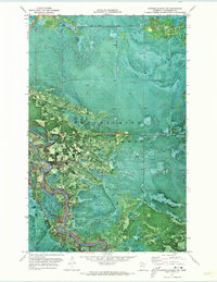
1971 Map of Johnson Landing NW
USGS Topo · Published 1973About this map
The Koochiching State Forest dominates this northern Minnesota landscape, where the dense timber of the North Woods is broken only by the winding paths of local waterways and logging access. The Little Fork River carves a deep, serpentine course through the western half of the territory, joined by its tributary, the Bear River, near the northern boundary. Produced as an orthophotomap, this 1971 survey combines aerial photography with topographic data, providing a literal view of the vegetation density and forest clearings as they existed in the early 1970s. The presence of a Winter Trail in the eastern section highlights the seasonal nature of transportation in this remote part of the state, where swampy ground and heavy snows historically dictated when people and equipment could move through the woods.
Find a feature on this map
6 named features on this map. Tap any name to fly to it.
Don’t see what you’re looking for? This feature index may not catch every label — zoom into the map to look around manually.
Map Details
Editions of this 1971 Johnson Landing NW Map
This is the sole edition of this map. No revisions or reprints were ever made.
Other maps of this area

1919 · Happy Land
USGS Topo · 1:62,500

1919 · M
USGS Topo · 1:62,500

1919 · Margie
USGS Topo · 1:62,500

1943 · Lindford
USGS Topo · 1:62,500

1954 · International Falls
USGS Topo · 1:250,000

1957 · International Falls
USGS Topo · 1:250,000

1958 · International Falls
USGS Topo · 1:250,000

1970 · Johnson Landing SE
USGS Topo · 1:24,000

1970 · Littlefork SE
USGS Topo · 1:24,000

1970 · Littlefork SW
USGS Topo · 1:24,000