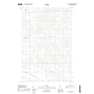
2019 Map of Nett Lake River East
USGS Topo · Published 2019About this map
Nett Lake River meanders through the expansive wetland terrain of Koochiching County, defining the drainage patterns of this northern Minnesota wilderness. In this late 2010s landscape, the infrastructure is sparse, dominated by a grid of township and range boundaries such as t66n r23w and t65n r24w. Human presence is concentrated along a handful of named corridors in the southern and eastern portions of the quadrangle, including the precisely labeled Industrial Ave and Resvn Hwy 2. These routes, along with O'Leary Trl, suggest a landscape managed for resource extraction or conservation. For researchers, the map provides a clear look at the intersection of modern road networks with the intricate, unchanged waterways that have long dictated movement through these woods and marshes.
Find a feature on this map
14 named features on this map. Tap any name to fly to it.
Don’t see what you’re looking for? This feature index may not catch every label — zoom into the map to look around manually.
Map Details
Editions of this 2019 Nett Lake River East Map
This is the sole edition of this map. No revisions or reprints were ever made.
Other maps of this area

1954 · International Falls
USGS Topo · 1:250,000

1957 · International Falls
USGS Topo · 1:250,000

1958 · International Falls
USGS Topo · 1:250,000

1969 · Ericsburg SE
USGS Topo · 1:24,000

1969 · Ray SW
USGS Topo · 1:24,000

1969 · Ericsburg SW
USGS Topo · 1:24,000

1970 · Nett Lake River SE
USGS Topo · 1:24,000
1970 · Nett Lake River East
USGS Topo · 1:24,000
1970 · Nett Lake SW
USGS Topo · 1:24,000
1970 · Nett Lake River West
USGS Topo · 1:24,000