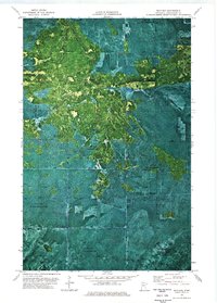
1973 Map of Wayland
USGS Topo · Published 1976About this map
Pine Island State Forest and the Red Lake Indian Reservation dominate this orthophotomap, which utilizes high-altitude aerial photography to show the complex bog and forest systems of Northern Minnesota. The orthophoto format provides a clear view of the dense vegetation patterns and wetlands that define this area of Koochiching County. Human activity in this remote environment is represented by seasonal infrastructure, including a Winter Road and Winter Trail, reflecting the necessity of frozen ground for transporting heavy equipment through the peatlands. The small settlement of Wayland is positioned within this expanse of timber and marsh. Because this sheet preserves the exact photographic texture of the land alongside standard topographic labels, it reveals the intricate network of drainage and tree cover that traditional line maps often simplify.
Find a feature on this map
8 named features on this map. Tap any name to fly to it.
Don’t see what you’re looking for? This feature index may not catch every label — zoom into the map to look around manually.
Map Details
Editions of this 1973 Wayland Map
This is the sole edition of this map. No revisions or reprints were ever made.
Other maps of this area

1919 · Birchdale
USGS Topo · 1:62,500

1919 · I
USGS Topo · 1:62,500

1954 · Roseau
USGS Topo · 1:250,000

1957 · Roseau
USGS Topo · 1:250,000

1958 · Roseau
USGS Topo · 1:250,000

1968 · Birchdale SW
USGS Topo · 1:24,000

1968 · Clementson SW
USGS Topo · 1:24,000

1968 · Clementson SE
USGS Topo · 1:24,000
1973 · Wayland SW
USGS Topo · 1:24,000
1973 · The Pines
USGS Topo · 1:24,000