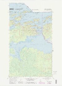
1969 Map of Island View
USGS Topo · Published 1987About this map
Rainy Lake dominates this northern frontier, where the international boundary between the United States and Canada cuts through a complex network of islands and narrows. In the late 1960s, the community of Island View served as a key gateway to these waters, located just west of the designated Voyageurs National Park lands. The map illustrates the region's transition from a resource-based economy, evidenced by local gravel pits and the Black Bay Lookout Tower, toward one defined by conservation and recreation. Notable landmarks such as Little American Island and Big American Island sit within the Black Bay Narrows, while the interior landscape is marked by a series of seasonal winter trails and the winding course of the Root River. This period captures the landscape as it was formalized into a national park, preserving the distinctive points and bays like Sha Sha Point and Harrison Bay.
Find a feature on this map
42 named features on this map. Tap any name to fly to it.
Don’t see what you’re looking for? This feature index may not catch every label — zoom into the map to look around manually.
Map Details
Editions of this 1969 Island View Map
4 editions found
Other maps of this area

1919 · International Falls
USGS Topo · 1:62,500

1954 · International Falls
USGS Topo · 1:250,000

1957 · International Falls
USGS Topo · 1:250,000

1958 · International Falls
USGS Topo · 1:250,000

1963 · Ranier
USGS Topo · 1:24,000

1969 · Island View
USGS Topo · 1:24,000

1969 · Ericsburg
USGS Topo · 1:24,000

1969 · Ray
USGS Topo · 1:24,000

1969 · Cranberry Bay
USGS Topo · 1:24,000

1969 · Ranier
USGS Topo · 1:24,000