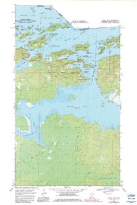
1969 Map of Island View
USGS Topo · Published 1983About this map
Rainy Lake dominates this northern frontier, where the international boundary between Canada and the United States threads through a labyrinth of islands and bays. The settlement of Island View sits perched on the shoreline, serving as a gateway to the newly established Voyageurs National Park. The landscape is a complex network of water and timber, punctuated by landmarks such as the Black Bay Lookout Tower and numerous family-named islands like Fransen Island and Dryweed Island. A network of seasonal Winter Trails crisscrosses the low-lying wetlands south of Black Bay, leading toward the Root River. This 1960s-era survey, updated in the early 1980s, captures a transitional period for the Border Waters, documenting the infrastructure of both the local timber economy and the conservation efforts that defined the Koochiching County coastline.
Find a feature on this map
47 named features on this map. Tap any name to fly to it.
Don’t see what you’re looking for? This feature index may not catch every label — zoom into the map to look around manually.
Map Details
Editions of this 1969 Island View Map
4 editions found
Other maps of this area

1919 · International Falls
USGS Topo · 1:62,500

1954 · International Falls
USGS Topo · 1:250,000

1957 · International Falls
USGS Topo · 1:250,000

1958 · International Falls
USGS Topo · 1:250,000

1963 · Ranier
USGS Topo · 1:24,000

1969 · Island View
USGS Topo · 1:24,000

1969 · Ericsburg
USGS Topo · 1:24,000

1969 · Ray
USGS Topo · 1:24,000

1969 · Cranberry Bay
USGS Topo · 1:24,000

1969 · Ranier
USGS Topo · 1:24,000