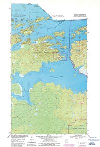
1969 Map of Island View
USGS Topo · Published 1987About this map
Rainy Lake dominates the northern landscape of this Koochiching County survey, defining a complex borderland of interconnected bays and rocky islands along the Canada United States boundary. The settlement of Island View serves as a gateway to the waters of Jackfish Bay, Grassy Bay, and Frank Bay, where the shoreline is punctuated by local landmarks like Sha Sha Point and Neil Point. The inclusion of Voyageurs National Park reflects the transition of this wilderness into a protected landscape, where history is marked by the Black Bay Lookout Tower and mining-era remnants on Little American Island. To the south, the terrain shifts from the island-dotted lake to the wetlands surrounding the Rat Root River, with a network of Winter Trails providing access through the dense woodland. This map documents a period when the timber and water resources of the North Woods were increasingly balanced with conservation and recreation.
Find a feature on this map
49 named features on this map. Tap any name to fly to it.
Don’t see what you’re looking for? This feature index may not catch every label — zoom into the map to look around manually.
Map Details
Editions of this 1969 Island View Map
4 editions found
Other maps of this area

1919 · International Falls
USGS Topo · 1:62,500

1954 · International Falls
USGS Topo · 1:250,000

1957 · International Falls
USGS Topo · 1:250,000

1958 · International Falls
USGS Topo · 1:250,000

1963 · Ranier
USGS Topo · 1:24,000

1969 · Island View
USGS Topo · 1:24,000

1969 · Ericsburg
USGS Topo · 1:24,000

1969 · Ray
USGS Topo · 1:24,000

1969 · Cranberry Bay
USGS Topo · 1:24,000

1969 · Ranier
USGS Topo · 1:24,000