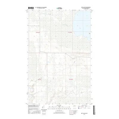
2016 Map of Nett Lake SW
USGS Topo · Published 2016About this map
Nett Lake and the marshy expanses of the Bois Forte Reservation define this northern Minnesota landscape. The terrain is a complex network of wetlands and waterways, where the Nett Lake River winds westward from the lake's open waters, passing Big Island along its eastern shore. Local transportation relies on a system of reservation routes and logging roads, including Resvn Hwy 5 and the aptly named Nett River Rd. To the south, the drainage patterns shift toward the Little Fork River, which cuts across the southwestern corner of the quadrangle. Smaller tributaries like Prairie Cr weave through the low-lying ground, illustrating the hydrological connection between these northern basins. This map provides a clear view of the rural infrastructure in Koochiching County, showing how roads like Sucker Rd and Marshall Tower Rd navigate the challenging, water-logged soils of the region.
Find a feature on this map
15 named features on this map. Tap any name to fly to it.
Don’t see what you’re looking for? This feature index may not catch every label — zoom into the map to look around manually.
Map Details
Editions of this 2016 Nett Lake SW Map
This is the sole edition of this map. No revisions or reprints were ever made.
Other maps of this area

1954 · Hibbing
USGS Topo · 1:250,000

1954 · International Falls
USGS Topo · 1:250,000

1957 · Hibbing
USGS Topo · 1:250,000

1957 · International Falls
USGS Topo · 1:250,000

1958 · International Falls
USGS Topo · 1:250,000

1958 · Hibbing
USGS Topo · 1:250,000

1964 · Hibbing
USGS Topo · 1:250,000

1969 · Nett Lake
USGS Topo · 1:24,000

1969 · Nett Lake NE
USGS Topo · 1:24,000

1970 · Rauch
USGS Topo · 1:24,000