1900s (20th Century) Maps of International Falls, Minnesota
Explore 10 historic maps of International Falls from the 1900s (20th Century). These maps offer a rare glimpse into what life looked like during the 1900s — showing old roads, neighborhoods, homes, and landmarks that have changed or disappeared over time.
Whether you're researching your family's past, planning a metal detecting trip, or studying how International Falls's landscape evolved across the 1900s, these high-resolution maps are a powerful tool for exploring the history of this region.
- Focus on a specific era: All maps on this page are from the 1900s, giving you a focused view of this time period.
- See what’s changed: Compare century-old streets, trails, and buildings to today's modern landscape using overlays and satellite layers.
- Research with precision: Use these maps for genealogy, historical research, land use analysis, or educational projects.
- View, download, or print: Maps are fully viewable online in high resolution, and can be downloaded or printed for your own records.
Start exploring International Falls's history through authentic maps from the 1900s. This is your window into the past.
International Falls, MN maps
(10)- 1919 Map of International Falls, 1943 Print
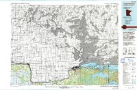
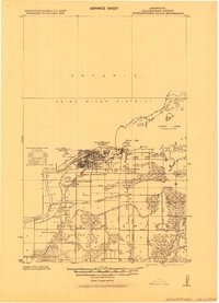 1919 International Falls1943 Print · USGSInternational Falls and the Canadian border are captured in the era of early industrial expansion. Researchers can trace the development of neighborhood additions and remote rail stops like Goldville, Nakoda, and the local Poor Farm along the Rainy River.
 - 1954 Map of International Falls, 1980 Print
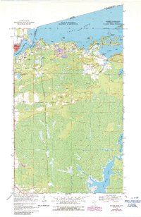
 1954 International Falls1980 Print · USGSThe Minnesota-Ontario borderlands come alive in this mid-century survey of the Rainy River region and the interconnected waterways that now form Voyageurs National Park. Genealogists and local historians can trace the rail-and-timber era through settlements like Littlefork, the Nett Lake Indian Reservation, and the Canadian National rail lines.
 - 1957 Map of International Falls
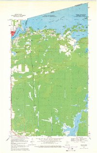
 1957 International Falls1957 Print · USGSThe Minnesota-Ontario borderlands come alive in the mid-fifties, showing the industrial nodes of International Falls and Fort Frances. Genealogists and historians can trace rail-tied settlements like Aylsworth and Littlefork or locate ancestral lands within the Nett Lake Indian Reservation.
 - 1958 Map of International Falls
 1958 International Falls1958 Print · USGSThe borderlands of northern Minnesota and Ontario are mapped here during the mid-fifties, centered on the river-and-rail hubs of the Northwoods. Researchers can trace the path of the Northern Pacific through Big Falls or locate early settlements like Ericsburg and Ranier.2 unique versions available
 - 1963 Map of Ranier, 1987 Print
 1963 Ranier1987 Print · USGSThe international border at Ranier and Fort Frances was a critical rail and river hub in the mid-to-late twentieth century. Local historians can trace the paths of the Canadian National railroad and identify landmarks like Point-O-Pines Ch and Falls Junction.
 - 1969 Map of Ranier, 1971 Print
 1969 Ranier1971 Print · USGSThe northern borderlands around the turn of the 1970s reveal a busy rail and river crossroads where the United States meets Canada. Trace the industrial footprint of Falls Junction and the lakefront docks of Ranier alongside local landmarks like Point-O-Pines Ch.2 unique versions available
 - 1969 Map of International Falls, 1972 Print
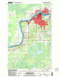
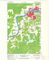 1969 International Falls1972 Print · USGSThe twin border towns of Fort Frances and International Falls are captured here during the late sixties. Researchers can trace the era's infrastructure from the US Customs station to local schools like Holler Sch and Forestland Sch.2 unique versions available
 - 1978 Map of International Falls, 1993 Print
 1978 International Falls1993 Print · USGSThe Minnesota-Ontario borderlands come alive in the late seventies, where the timber and rail economy meets the lake wilderness. Genealogists and local historians can trace the growth of International Falls and Ranier or locate island landmarks like Grindstone Island and Bushyhead Island.
 - 1999 Map of International Falls, 2003 Print
 1999 International Falls2003 Print · USGSInternational Falls and the Canadian border at the turn of the millennium show a landscape defined by the Rainy River and northern industry. Genealogists and local historians can trace civic life through Forest Hill Cem, Holler Sch, and the Old Winter Trail.
 - 1999 Map of Ranier, 2003 Print
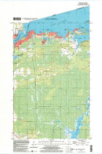 1999 Ranier2003 Print · USGSRanier and the international border are captured here at the end of the millennium, showing a landscape shaped by water and rail. Researchers can trace local landmarks like Falls Junction, the sprawling Koochiching State Forest, and the winding Rat Root River.
End of results
Showing maps 1-10 of 10
Top cities near International Falls
Top neighborhoods of International Falls
Frequently asked questions
- What are the different types of historical maps available for International Falls?
- What is the oldest map of International Falls?
- Where can I purchase historical maps of International Falls for my home or office?
- Where can I download high-res historical maps of International Falls?
- Are there historical topographic maps available for International Falls?
- Is there historical aerial imagery available for International Falls?
- Where are historical maps of International Falls sourced from?