1910s Maps of Norman County, Minnesota
Explore 4 historic maps of Norman County from the 1910s. These maps offer a rare glimpse into what life looked like during the 1910s — showing old roads, neighborhoods, homes, and landmarks that have changed or disappeared over time.
Whether you're researching your family's past, planning a metal detecting trip, or studying how Norman County's landscape evolved across the 1910s, these high-resolution maps are a powerful tool for exploring the history of this region.
- Focus on a specific era: All maps on this page are from the 1910s, giving you a focused view of this time period.
- See what’s changed: Compare century-old streets, trails, and buildings to today's modern landscape using overlays and satellite layers.
- Research with precision: Use these maps for genealogy, historical research, land use analysis, or educational projects.
- View, download, or print: Maps are fully viewable online in high resolution, and can be downloaded or printed for your own records.
Start exploring Norman County's history through authentic maps from the 1910s. This is your window into the past.
Norman County, MN maps
(4)- 1918 Map of Hendrum
 1918 Hendrum1918 Print · USGSThe Red River Valley borderlands are captured here just before the end of the Great War, showing the vital rail and river corridor between North Dakota and Minnesota. Researchers can trace the early footprints of Shelly Station, Halstad Station, and Hendrum Station along the Great Northern railroad.
 - 1918 Map of Twin Valley
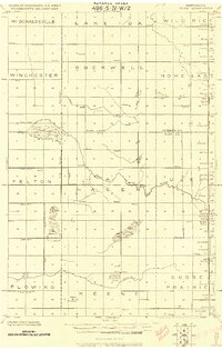
 1918 Twin Valley1918 Print · USGSNorman County is captured during the Great War era as a burgeoning agricultural district defined by the railroad and the river. Genealogists can trace the specific locations of family-owned farms near Twin Valley, Gary, and rural landmarks like the Betcher School or Cem. Church.
 - 1918 Map of Flom
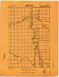
 1918 Flom1918 Print · USGSNorthwestern Minnesota's farming townships are captured here at the close of the First World War. Researchers can trace rural school districts and family church sites near Fossum, Flom P.O., and along the South Branch Wild Rice River.
 - 1918 Map of Ulen
 1918 Ulen1918 Print · USGSClay and Norman counties at the end of the Great War show a landscape being reshaped by the Northern Pacific railroad and drainage works. Researchers can trace rural school locations, cemeteries, and early settlements like Ulen and Syre among the prairie townships.2 unique versions available
End of results
Showing maps 1-4 of 4
Top cities of Norman County
- Ada historical maps
- Twin Valley historical maps
- Halstad historical maps
- Hendrum historical maps
- Shelly historical maps
- Gary historical maps
See more
Frequently asked questions
- What are the different types of historical maps available for Norman County?
- What is the oldest map of Norman County?
- Where can I purchase historical maps of Norman County for my home or office?
- Where can I download high-res historical maps of Norman County?
- Are there historical topographic maps available for Norman County?
- Is there historical aerial imagery available for Norman County?
- Where are historical maps of Norman County sourced from?