1910s Maps of Roseau County, Minnesota
Explore 10 historic maps of Roseau County from the 1910s. These maps offer a rare glimpse into what life looked like during the 1910s — showing old roads, neighborhoods, homes, and landmarks that have changed or disappeared over time.
Whether you're researching your family's past, planning a metal detecting trip, or studying how Roseau County's landscape evolved across the 1910s, these high-resolution maps are a powerful tool for exploring the history of this region.
- Focus on a specific era: All maps on this page are from the 1910s, giving you a focused view of this time period.
- See what’s changed: Compare century-old streets, trails, and buildings to today's modern landscape using overlays and satellite layers.
- Research with precision: Use these maps for genealogy, historical research, land use analysis, or educational projects.
- View, download, or print: Maps are fully viewable online in high resolution, and can be downloaded or printed for your own records.
Start exploring Roseau County's history through authentic maps from the 1910s. This is your window into the past.
Roseau County, MN maps
(10)- 1918 Map of Goos
 1918 Goos1918 Print · USGSNorthern Minnesota near the Canadian border is shown during a period of massive land reclamation and rail expansion. Genealogists and historians can trace the early drainage network alongside the Great Northern tracks and locate sites like Salol, Mandus, and Boisvert.
 - 1918 Map of Winterroad
 1918 Winterroad1918 Print · USGSNorthern Minnesota’s drainage and timber frontiers are documented here just after the war, showing the massive engineering projects intended to dry the landscape. Local historians can trace the early township divisions of Eugene and Yale alongside landmarks like School 25 and Winter Road Lake.2 unique versions available
 - 1918 Map of Roosevelt
 1918 Roosevelt1918 Print · USGSNorthern Minnesota's wooded frontier is captured here at the end of the Great War, as the railway transformed the lake country. Genealogists and historians can trace early school sites and track the Canadian Northern rail line through Roosevelt and Swift.
 - 1918 Map of Pencer
 1918 Pencer1918 Print · USGSNorthern Minnesota's borderlands appear in the late nineteen-teens as a landscape of timbered swamps and new drainage districts. Genealogists and local researchers can trace early rural life through scattered settlements like Pencer, Wannaska, and Casperson, or locate the Old Indian Reservation Boundary Line.
 - 1918 Map of Roseau
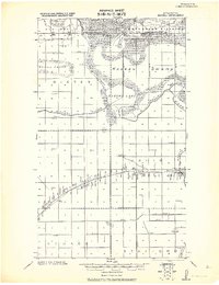 1918 Roseau1918 Print · USGSNorthern Minnesota’s borderlands come into focus at the end of the Great War, showing a landscape defined by water management and the rail. Trace early schoolhouse locations and rail crossings like Farm Xing near the Great Northern R. R. and Roseau Lake.2 unique versions available
 - 1918 Map of Garland
 1918 Garland1918 Print · USGSNorthern Minnesota borderlands during the First World War reveal a landscape of drainage ditches and early rural post offices. Genealogists can locate long-vanished sites like P.O. Garland and Homolka P.O. or trace the Old Indian Reservation Boundary Line.
 - 1918 Map of Warroad
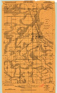 1918 Warroad1918 Print · USGSNorthern Minnesota's borderlands come alive in the decade following the drainage surveys, showing the international rail hub at Warroad and the marshy shores of Lake of the Woods. Genealogists can trace early homesteads and schools near Cedarbend, America, and along the Warroad River.
 - 1918 Map of Greenbush, 1943 Print
 1918 Greenbush1943 Print · USGSNorthern Minnesota farming and drainage districts are captured in the late teens as the Great Northeastern railroad connects Greenbush and Strathcona. Genealogists can trace early homestead life via rural landmarks like School 34, Herb, and the Cem. near the county line.
 - 1919 Map of Pelan
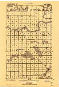
 1919 Pelan1919 Print · USGSNorthwestern Minnesota at the close of the Great War was a landscape defined by massive drainage projects. Researchers can trace the early townships of Pelan and Linda, identifying the locations of numerous rural Schools and local hubs like Sanwick.
 - 1919 Map of Badger, 1924 Print
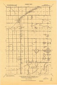
 1919 Badger1924 Print · USGSThe Canada-United States borderlands in Roseau County come into focus during this post-war period of drainage and agricultural expansion. Local historians can trace the early rail network at Badger and locate rural landmarks like School Duxby and Haug.
End of results
Showing maps 1-10 of 10
Top cities of Roseau County
- Roseau historical maps
- Warroad historical maps
- Greenbush historical maps
- Badger historical maps
- Ross historical maps
- Malung historical maps
See more
Frequently asked questions
- What are the different types of historical maps available for Roseau County?
- What is the oldest map of Roseau County?
- Where can I purchase historical maps of Roseau County for my home or office?
- Where can I download high-res historical maps of Roseau County?
- Are there historical topographic maps available for Roseau County?
- Is there historical aerial imagery available for Roseau County?
- Where are historical maps of Roseau County sourced from?