1940s Maps of Roseau County, Minnesota
Explore 3 historic maps of Roseau County from the 1940s. These maps offer a rare glimpse into what life looked like during the 1940s — showing old roads, neighborhoods, homes, and landmarks that have changed or disappeared over time.
Whether you're researching your family's past, planning a metal detecting trip, or studying how Roseau County's landscape evolved across the 1940s, these high-resolution maps are a powerful tool for exploring the history of this region.
- Focus on a specific era: All maps on this page are from the 1940s, giving you a focused view of this time period.
- See what’s changed: Compare century-old streets, trails, and buildings to today's modern landscape using overlays and satellite layers.
- Research with precision: Use these maps for genealogy, historical research, land use analysis, or educational projects.
- View, download, or print: Maps are fully viewable online in high resolution, and can be downloaded or printed for your own records.
Start exploring Roseau County's history through authentic maps from the 1940s. This is your window into the past.
Roseau County, MN maps
(3)- 1943 Map of Roosevelt
 1943 Roosevelt1943 Print · USGSNear the international boundary in the 1940s, this area shows the early development of Roseau and Beltrami Counties around the Canadian Northern line. Researchers can trace the layout of Roosevelt, Arnesen, and Swift alongside the timbered landscapes of Laona.
 - 1943 Map of Goos
 1943 Goos1943 Print · USGSNorthwestern Minnesota territory along the international border is mapped here during the Second World War based on earlier military surveys. Researchers can trace the Great Northern rail line and locate early rural landmarks like Salol, Mandus, and various School sites.
 - 1943 Map of Warroad
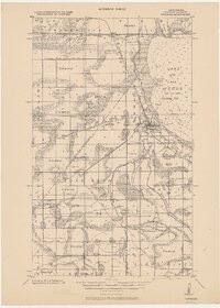 1943 Warroad1943 Print · USGSThe northern borderlands of Roseau County are captured here in the early 20th century, showing a landscape defined by rail junctions and ambitious drainage projects. Researchers can trace family sites near Warroad, find rural schools in America, or follow the old Great Northern RR line through the Red Lake Indian Reservation.
End of results
Showing maps 1-3 of 3
Top cities of Roseau County
- Roseau historical maps
- Warroad historical maps
- Greenbush historical maps
- Badger historical maps
- Ross historical maps
- Malung historical maps
See more
Frequently asked questions
- What are the different types of historical maps available for Roseau County?
- What is the oldest map of Roseau County?
- Where can I purchase historical maps of Roseau County for my home or office?
- Where can I download high-res historical maps of Roseau County?
- Are there historical topographic maps available for Roseau County?
- Is there historical aerial imagery available for Roseau County?
- Where are historical maps of Roseau County sourced from?