1900s (20th Century) Maps of Angleworm Lake, Minnesota
Explore 7 historic maps of Angleworm Lake from the 1900s (20th Century). These maps offer a rare glimpse into what life looked like during the 1900s — showing old roads, neighborhoods, homes, and landmarks that have changed or disappeared over time.
Whether you're researching your family's past, planning a metal detecting trip, or studying how Angleworm Lake's landscape evolved across the 1900s, these high-resolution maps are a powerful tool for exploring the history of this region.
- Focus on a specific era: All maps on this page are from the 1900s, giving you a focused view of this time period.
- See what’s changed: Compare century-old streets, trails, and buildings to today's modern landscape using overlays and satellite layers.
- Research with precision: Use these maps for genealogy, historical research, land use analysis, or educational projects.
- View, download, or print: Maps are fully viewable online in high resolution, and can be downloaded or printed for your own records.
Start exploring Angleworm Lake's history through authentic maps from the 1900s. This is your window into the past.
Angleworm Lake, MN maps
(7)- 1957 Map of Quetico, 1967 Print
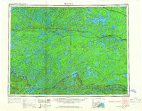 1957 Quetico1967 Print · USGSThe Ontario-Minnesota borderlands are captured here in the mid-fifties, showing the vast wilderness of the Boundary Waters before modern development. Genealogists and researchers can trace rail settlements along the Canadian National Railways including Atikokan, Sapawe, and Kashabowie.2 unique versions available
 - 1963 Map of Fourtown Lake, 1964 Print
 1963 Fourtown Lake1964 Print · USGSThe Boundary Waters wilderness of the early sixties is preserved here, showing a landscape defined by water and primitive trails. You can trace historic canoe routes through Fourtown Lake, Tin Can Mike Lake, and along the Range River to Jackfish Bay.4 unique versions available
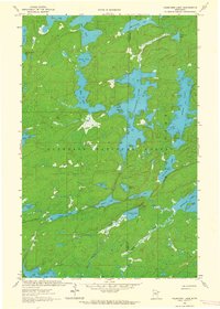
 - 1963 Map of Angleworm Lake, 1964 Print
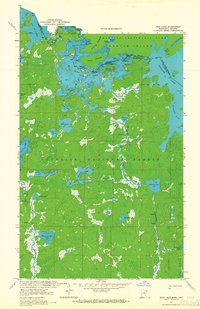
 1963 Angleworm Lake1964 Print · USGSThe northern Minnesota wilderness is captured here in the early 1960s, showing a landscape shaped by glacial lakes and early forest management. Trace the historic Echo Trail and find landmarks like the Angleworm Lookout Tower and Pictured Rock.2 unique versions available
 - 1963 Map of Friday Bay, 1965 Print
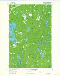
 1963 Friday Bay1965 Print · USGSThe international borderlands of Minnesota and Ontario were a pristine wilderness in the 1960s. Researchers can trace the ancient canoe routes between Friday Bay and Saturday Bay or locate secluded waters like Ritual Lake and Bear Trap Lake.2 unique versions available
 - 1963 Map of Iron Lake, 1965 Print
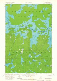
 1963 Iron Lake1965 Print · USGSThe international border between Minnesota and Ontario was a roadless expanse of lakes and portages in the 1960s. Outdoor enthusiasts and researchers can trace ancient canoe routes through Curtain Falls, the islands of Iron Lake, and the remote Nibin Lake.2 unique versions available
 - 1968 Map of Quetico
 1968 Quetico1968 Print · USGSThe Ontario-Minnesota borderlands are captured here in the late 1960s, showing the vast wilderness of the Boundary Waters. Researchers can trace the Canadian National rail line through Atikokan or explore the interior lakes of Quetico Provincial Park and Hunter Island.
 - 1977 Map of Basswood Lake, 1994 Print
 1977 Basswood Lake1994 Print · USGSThe Boundary Waters and Ontario’s wilderness meet in the late seventies across a vast network of interconnected glacial lakes. Researchers can trace the international line through Basswood Lake, Crooked Lake, and around the massive Hunter Island.
End of results
Showing maps 1-7 of 7
Top cities near Angleworm Lake
Frequently asked questions
- What are the different types of historical maps available for Angleworm Lake?
- What is the oldest map of Angleworm Lake?
- Where can I purchase historical maps of Angleworm Lake for my home or office?
- Where can I download high-res historical maps of Angleworm Lake?
- Are there historical topographic maps available for Angleworm Lake?
- Is there historical aerial imagery available for Angleworm Lake?
- Where are historical maps of Angleworm Lake sourced from?