1940s Maps of Hoyt Lakes, Minnesota
Explore 4 historic maps of Hoyt Lakes from the 1940s. These maps offer a rare glimpse into what life looked like during the 1940s — showing old roads, neighborhoods, homes, and landmarks that have changed or disappeared over time.
Whether you're researching your family's past, planning a metal detecting trip, or studying how Hoyt Lakes's landscape evolved across the 1940s, these high-resolution maps are a powerful tool for exploring the history of this region.
- Focus on a specific era: All maps on this page are from the 1940s, giving you a focused view of this time period.
- See what’s changed: Compare century-old streets, trails, and buildings to today's modern landscape using overlays and satellite layers.
- Research with precision: Use these maps for genealogy, historical research, land use analysis, or educational projects.
- View, download, or print: Maps are fully viewable online in high resolution, and can be downloaded or printed for your own records.
Start exploring Hoyt Lakes's history through authentic maps from the 1940s. This is your window into the past.
Hoyt Lakes, MN maps
(4)- 1949 Map of Aurora, 1956 Print
 1949 Aurora1956 Print · USGSThe Iron Range of northern Minnesota comes alive in this post-war survey of the mining landscape around Aurora. Researchers can trace the industrial footprint of the St James Pit, the community of Mesaba, and family landmarks near Colby Lake.
 - 1949 Map of Isaac Lake, 1958 Print
 1949 Isaac Lake1958 Print · USGSSt. Louis County timber and iron lands are documented here during the late 1940s as industry pushed into the northern woods. Researchers can locate the Arvo Cem, trace the Duluth Missabe and Iron Range rail line, and find Armanda Camp.4 unique versions available
 - 1949 Map of Allen, 1958 Print
 1949 Allen1958 Print · USGSThe Mesaba Range and the Iron Range railroad system are in full operation during this post-war era in northern Minnesota. Genealogists and historians can trace the early industrial footprint at Allen, Wyman, and remote outposts like Niemi Camp.
 - 1949 Map of Embarrass, 1959 Print
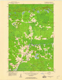 1949 Embarrass1959 Print · USGSThe Embarrass River valley in the late 1940s shows a landscape of glacial lakes and northern timber. Genealogists can locate School No 70 and the village of Embarrass along the Duluth Missabe and Iron Range railroad.4 unique versions available
End of results
Showing maps 1-4 of 4
Top cities near Hoyt Lakes
- Aurora historical maps
- Babbitt historical maps
- Biwabik historical maps
- Embarrass historical maps
- Fairbanks historical maps
Top neighborhoods of Hoyt Lakes
- Colby historical maps
- Mesaba historical maps
- Allen historical maps
- Hinsdale historical maps
- Wyman historical maps
- Old Mesaba historical maps
Frequently asked questions
- What are the different types of historical maps available for Hoyt Lakes?
- What is the oldest map of Hoyt Lakes?
- Where can I purchase historical maps of Hoyt Lakes for my home or office?
- Where can I download high-res historical maps of Hoyt Lakes?
- Are there historical topographic maps available for Hoyt Lakes?
- Is there historical aerial imagery available for Hoyt Lakes?
- Where are historical maps of Hoyt Lakes sourced from?