1980s Maps of Calhoun County, Mississippi
Explore 15 historic maps of Calhoun County from the 1980s. These maps offer a rare glimpse into what life looked like during the 1980s — showing old roads, neighborhoods, homes, and landmarks that have changed or disappeared over time.
Whether you're researching your family's past, planning a metal detecting trip, or studying how Calhoun County's landscape evolved across the 1980s, these high-resolution maps are a powerful tool for exploring the history of this region.
- Focus on a specific era: All maps on this page are from the 1980s, giving you a focused view of this time period.
- See what’s changed: Compare century-old streets, trails, and buildings to today's modern landscape using overlays and satellite layers.
- Research with precision: Use these maps for genealogy, historical research, land use analysis, or educational projects.
- View, download, or print: Maps are fully viewable online in high resolution, and can be downloaded or printed for your own records.
Start exploring Calhoun County's history through authentic maps from the 1980s. This is your window into the past.
Calhoun County, MS maps
(15)- 1983 Map of Pine Valley
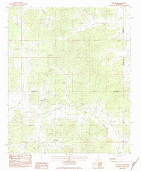
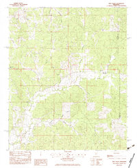 1983 Pine Valley1983 Print · USGSYalobusha and Calhoun Counties are captured in the early eighties, showing a landscape of timbered ridges and small family homesteads. Genealogists can locate community anchors like Bethel Ch, Macedonia Cem, and the settlement of Pine Valley.
 - 1983 Map of Water Valley East
 1983 Water Valley East1983 Print · USGSThe hills of north-central Mississippi are mapped here in the early eighties, centered on the tri-county borders of Lafayette, Yalobusha, and Calhoun. Genealogists can trace family roots through numerous country landmarks like South Hopewell Ch, Oak Ridge Cem, and Wyatt Chapel Cem.
 - 1983 Map of Cadaretta, 1984 Print
 1983 Cadaretta1984 Print · USGSNorth Mississippi's rural communities at the Calhoun and Webster County line are captured here in the early eighties. Genealogists can trace family footprints at Old Salem Cem and Pittman Cem or locate the rural pulpits of Philadelphia Ch and Embry Ch.
 - 1983 Map of Bellefontaine, 1984 Print
 1983 Bellefontaine1984 Print · USGSThe Webster and Calhoun County borderlands are captured here in the early eighties, still defined by the historic Old Indian Treaty Boundary. Genealogists can trace family names at Vance Cem, Spencer Cem, and the community surrounding Slate Spring.
 - 1983 Map of Bruce, 1984 Print
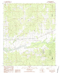
 1983 Bruce1984 Print · USGSThe Skuna River valley and the southern reaches of Bruce define this area in the early eighties. Genealogists and historians can trace local landmarks like Calhoun Academy, Bridges Chapel, and the Mississippi and Skuna Valley railroad.
 - 1983 Map of Benwood, 1984 Print
 1983 Benwood1984 Print · USGSThe Yalobusha and Calhoun county line area in the early eighties shows a landscape of river canals and historical markers. Genealogists and historians can trace the Old Indian Treaty Boundary or locate remote sites like Dividing Ridge Ch and Jones Cem.
 - 1983 Map of Gore Springs, 1984 Print
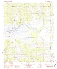 1983 Gore Springs1984 Print · USGSGrenada and Yalobusha counties are captured in the early 1980s as the waters of Grenada Lake shape the local landscape. Researchers can locate family landmarks such as Parker Cem, Mt Nebo Ch, and the community of Gore Springs.
 - 1983 Map of Calhoun City, 1984 Print
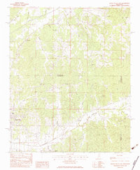
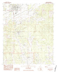
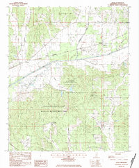
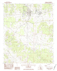 1983 Calhoun City1984 Print · USGSCalhoun County in the early eighties shows a landscape shaped by ancient borders and river networks. Researchers can trace the Old Indian Treaty Boundary near Calhoun City or locate family history at Cross Road Cem and Benele Cem.
 - 1983 Map of Sweatman, 1984 Print
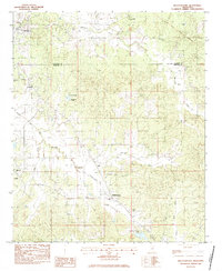
 1983 Sweatman1984 Print · USGSNorth-central Mississippi rural life in the early eighties is preserved here at the crossroads of four counties. Genealogists can trace family names and early congregations at Wells Cem, Blackjack Ch, and the settlement of Sweatman.
 - 1983 Map of Skuna, 1984 Print
 1983 Skuna1984 Print · USGSCalhoun County's rural heartland is captured here in the early 1980s, showcasing the engineered waterways and large conservation tracts of northern Mississippi. Family historians can locate rural landmarks such as Zion Springs Ch and the small settlements of Pittman and Shepherd.
 - 1983 Map of Big Creek, 1984 Print
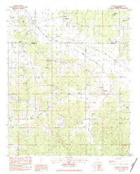
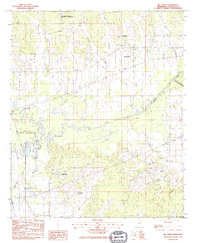 1983 Big Creek1984 Print · USGSCalhoun County in the early eighties was defined by its winding waterways and managed wilderness areas. Researchers can trace the Indian Treaty Boundary Line or locate family roots near Sabougla, Magness Cem, and Chapel Hill Ch.
 - 1984 Map of West Point
 1984 West Point1984 Print · USGSNorth-Central Mississippi in the mid-eighties shows a landscape defined by massive water management projects and dense timberlands. Researchers can trace the legacy of rural settlements like Geeslin Corner or the rail corridors of the Illinois Central Gulf RR near Grenada Lake.3 unique versions available
 - 1984 Map of Tupelo
 1984 Tupelo1984 Print · USGSNorth Mississippi in the 1980s is defined by its massive river basin reservoirs and the growing regional hubs of Tupelo and Oxford. Researchers can trace the legacy of the Pontotoc Ridge, find the University of Mississippi, and map early Interstate corridors near Sardis Lake.3 unique versions available
 - 1984 Map of Oxford, 1985 Print
 1984 Oxford1985 Print · USGSOxford and its surrounding hill country are captured in the mid-eighties as university life and rural industry intersected. Genealogists and historians can trace rail lines like the ST LOUIS-SAN FRANCISCO RY and locate old rural centers such as College Hill Sta and Lafayette Springs.
 - 1984 Map of Grenada, 1990 Print
 1984 Grenada1990 Print · USGSNorth Central Mississippi’s river valleys and conservation lands are captured here in the mid-1980s. Researchers can trace the sprawling Camp Mc Cain, the Illinois Central Gulf rail line, and the historic Treaty Boundary.
End of results
Showing maps 1-15 of 15
Top cities of Calhoun County
- Bruce historical maps
- Calhoun City historical maps
- Derma historical maps
- Vardaman historical maps
- Pittsboro historical maps
- Big Creek historical maps
Frequently asked questions
- What are the different types of historical maps available for Calhoun County?
- What is the oldest map of Calhoun County?
- Where can I purchase historical maps of Calhoun County for my home or office?
- Where can I download high-res historical maps of Calhoun County?
- Are there historical topographic maps available for Calhoun County?
- Is there historical aerial imagery available for Calhoun County?
- Where are historical maps of Calhoun County sourced from?