1970s Maps of Calhoun County, Mississippi
Explore 12 historic maps of Calhoun County from the 1970s. These maps offer a rare glimpse into what life looked like during the 1970s — showing old roads, neighborhoods, homes, and landmarks that have changed or disappeared over time.
Whether you're researching your family's past, planning a metal detecting trip, or studying how Calhoun County's landscape evolved across the 1970s, these high-resolution maps are a powerful tool for exploring the history of this region.
- Focus on a specific era: All maps on this page are from the 1970s, giving you a focused view of this time period.
- See what’s changed: Compare century-old streets, trails, and buildings to today's modern landscape using overlays and satellite layers.
- Research with precision: Use these maps for genealogy, historical research, land use analysis, or educational projects.
- View, download, or print: Maps are fully viewable online in high resolution, and can be downloaded or printed for your own records.
Start exploring Calhoun County's history through authentic maps from the 1970s. This is your window into the past.
Calhoun County, MS maps
(12)- 1972 Map of Paris, 1974 Print
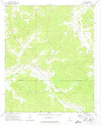 1972 Paris1974 Print · USGSLafayette County rural life is well-documented in the early seventies, centered on the crossroads at Paris. Researchers can trace old family roots through sites like Rock Hill Ch, Delay, and several smaller cemeteries near Otoucalofa Creek.
 - 1972 Map of Robbs, 1974 Print
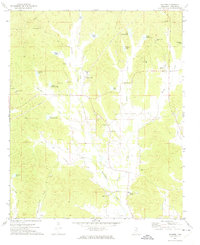
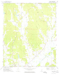
 1972 Robbs1974 Print · USGSThis rural Mississippi landscape at the junction of three counties features the scattered communities and church-centered social life of the early 1970s. Researchers can locate family landmarks such as Robbs Chapel, Indian Creek Cem, and the settlement of Reid.
 - 1972 Map of Atlanta, 1974 Print
 1972 Atlanta1974 Print · USGSNortheast Mississippi’s rural landscape is captured here in the early seventies, dominated by the canalization of major watercourses. Genealogists can locate family landmarks such as Old Pleasant Grove Cem, Midway Ch, and Collage Hill Ch.
 - 1972 Map of Banner, 1974 Print
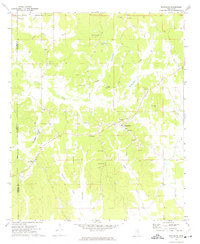
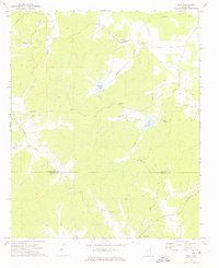
 1972 Banner1974 Print · USGSCalhoun County in the early seventies shows a landscape of family-named lakes and rural crossroads churches. Genealogists can trace local roots through Rapers Chapel, Reasons Cem, and settlements like Banner or Ellard.
 - 1972 Map of Vardaman, 1974 Print
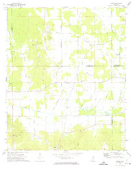
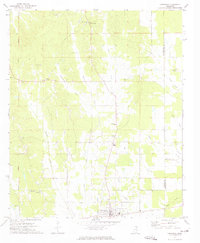 1972 Vardaman1974 Print · USGSThe area surrounding Vardaman in the early 1970s reflects a landscape of rural communities and crossroads. Researchers can trace family roots through sites like Georgies Chapel, New Liberty Ch, and the Reid Lookout Tower.2 unique versions available
 - 1972 Map of Hohenlinden, 1974 Print
 1972 Hohenlinden1974 Print · USGSWebster County's rural communities and creek valleys are captured here in the early seventies, just as the landscape remained defined by small settlements and winding forest roads. Genealogists can trace family sites at Old Shady Grove Cem or locate historic pulpits like Popular Springs Ch and Hebron Ch.
 - 1972 Map of Randolph, 1974 Print
 1972 Randolph1974 Print · USGSRandolph and the surrounding Pontotoc County countryside are shown here in the early 1970s as a network of small family farms and rural churches. Genealogists can trace family names through numerous local burial grounds including Salmon Cem and Harrison-Tutor Cem, or locate landmarks like Camp Yocona.
 - 1972 Map of Sarepta, 1974 Print
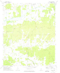
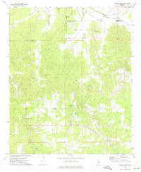
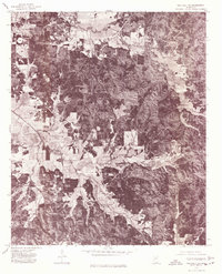
 1972 Sarepta1974 Print · USGSCalhoun County's rural landscape is captured here in the early 1970s, showing a region defined by the Skuna River and its many tributaries. Researchers can locate numerous local landmarks including Lantrip Ch, Duff Chapel, and the Hastings Landing Strip.
 - 1972 Map of Tula, 1975 Print
 1972 Tula1975 Print · USGSLafayette and Calhoun Counties are captured here in the early seventies, showing a landscape defined by the Yocona River and rural crossroads. Local historians can trace the foundations of Tula and Sarepta alongside sites like Stutson Chapel and Old Dallas Cemetery.
 - 1976 Map of Pittsboro SE, 1977 Print
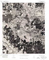 1976 Pittsboro SE1977 Print · USGSCalhoun County in the mid-seventies is seen here through detailed aerial photography, showing the rural landscape around Calhoun City. Researchers can trace land use patterns and water management systems like the Yalobusha Canal and the town grid of Derma.
 - 1976 Map of Pittsboro NE, 1977 Print
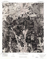 1976 Pittsboro NE1977 Print · USGSNorthern Calhoun County comes into focus in the mid-1970s, showing the intersection of agricultural land and managed timber. Researchers can trace the developed streets of Bruce and the path of the Skuna River Canal through the valley.
 - 1976 Map of Walthall NE, 1977 Print
 1976 Walthall NE1977 Print · USGSWebster County’s rural landscape is revealed through mid-seventies aerial imagery, documenting the timberlands and homesteads of northern Mississippi. Researchers can locate exact building footprints and property clearings near Bellefontaine, Slate Spring, and Embry.
End of results
Showing maps 1-12 of 12
Top cities of Calhoun County
- Bruce historical maps
- Calhoun City historical maps
- Derma historical maps
- Vardaman historical maps
- Pittsboro historical maps
- Big Creek historical maps
Frequently asked questions
- What are the different types of historical maps available for Calhoun County?
- What is the oldest map of Calhoun County?
- Where can I purchase historical maps of Calhoun County for my home or office?
- Where can I download high-res historical maps of Calhoun County?
- Are there historical topographic maps available for Calhoun County?
- Is there historical aerial imagery available for Calhoun County?
- Where are historical maps of Calhoun County sourced from?