1960s Maps of Franklin County, Mississippi
Explore 4 historic maps of Franklin County from the 1960s. These maps offer a rare glimpse into what life looked like during the 1960s — showing old roads, neighborhoods, homes, and landmarks that have changed or disappeared over time.
Whether you're researching your family's past, planning a metal detecting trip, or studying how Franklin County's landscape evolved across the 1960s, these high-resolution maps are a powerful tool for exploring the history of this region.
- Focus on a specific era: All maps on this page are from the 1960s, giving you a focused view of this time period.
- See what’s changed: Compare century-old streets, trails, and buildings to today's modern landscape using overlays and satellite layers.
- Research with precision: Use these maps for genealogy, historical research, land use analysis, or educational projects.
- View, download, or print: Maps are fully viewable online in high resolution, and can be downloaded or printed for your own records.
Start exploring Franklin County's history through authentic maps from the 1960s. This is your window into the past.
Franklin County, MS maps
(4)- 1961 Map of Crosby, 1962 Print
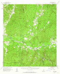 1961 Crosby1962 Print · USGSThe Homochitto River valley and its neighboring oil fields are captured here in the early sixties as they span four Mississippi counties. Researchers can trace rural lineages through numerous family sites like Dorsey Cem, Perrytown Ch, and the Illinois Central Railroad corridor.3 unique versions available
 - 1962 Map of Fayette, 1964 Print
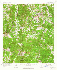 1962 Fayette1964 Print · USGSMississippi's river-country interior in the early sixties reveals a landscape of oil fields and ancient earthworks. Genealogists and historians can trace family-named sites like Emerald Mound, Hicks Cem, and the rural Daughters Temple.2 unique versions available
 - 1962 Map of Bude, 1964 Print
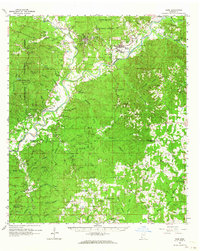 1962 Bude1964 Print · USGSSouthwest Mississippi's timber and oil country comes to life in the early sixties, centered on the lumber and rail hubs of Meadville and Bude. Genealogists can trace family lines through dozen of rural landmarks like Byrds Chapel, Smyrna Cemetery, and the West Bude Oil Field.2 unique versions available
 - 1963 Map of Union Church, 1964 Print
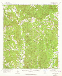 1963 Union Church1964 Print · USGSSouthwest Mississippi in the early sixties was defined by the timbered stretches of the Homochitto National Forest and the Mississippi Central railroad. Researchers can trace rural lineages through numerous small settlements and family burial sites like Union Church, Perth, and the Singletary Cem.2 unique versions available
End of results
Showing maps 1-4 of 4
Top cities of Franklin County
Frequently asked questions
- What are the different types of historical maps available for Franklin County?
- What is the oldest map of Franklin County?
- Where can I purchase historical maps of Franklin County for my home or office?
- Where can I download high-res historical maps of Franklin County?
- Are there historical topographic maps available for Franklin County?
- Is there historical aerial imagery available for Franklin County?
- Where are historical maps of Franklin County sourced from?