1970s Maps of Franklin County, Mississippi
Explore 3 historic maps of Franklin County from the 1970s. These maps offer a rare glimpse into what life looked like during the 1970s — showing old roads, neighborhoods, homes, and landmarks that have changed or disappeared over time.
Whether you're researching your family's past, planning a metal detecting trip, or studying how Franklin County's landscape evolved across the 1970s, these high-resolution maps are a powerful tool for exploring the history of this region.
- Focus on a specific era: All maps on this page are from the 1970s, giving you a focused view of this time period.
- See what’s changed: Compare century-old streets, trails, and buildings to today's modern landscape using overlays and satellite layers.
- Research with precision: Use these maps for genealogy, historical research, land use analysis, or educational projects.
- View, download, or print: Maps are fully viewable online in high resolution, and can be downloaded or printed for your own records.
Start exploring Franklin County's history through authentic maps from the 1970s. This is your window into the past.
Franklin County, MS maps
- 1972 Map of Smithdale, 1974 Print
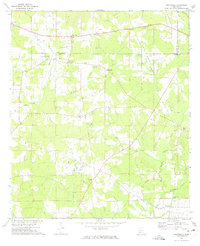 1972 Smithdale1974 Print · USGSAmite County and Franklin County are captured here in the early seventies, a landscape of family farms and rural industry along the Amite River. Researchers can locate several family burial sites like Lumpkin Cem and old country parishes such as Oak Grove Ch.
 - 1972 Map of McCall Creek, 1974 Print
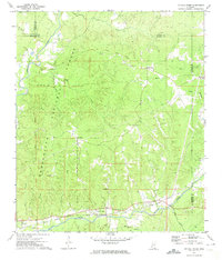 1972 McCall Creek1974 Print · USGSFranklin and Lincoln counties are shown here in the early seventies, where the massive Homochitto National Forest meets local rail towns. Genealogists can locate family burial sites like Wright Cem and rural centers such as McCall Creek or Shucktown.
 - 1972 Map of Little Springs, 1974 Print
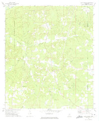 1972 Little Springs1974 Print · USGSFranklin and Lincoln counties in the early 1970s are shown here as a landscape of timber and rural homesteads. Genealogists can trace family names at McCall Ch, Cotton Cem, and the settlement of Little Springs near the historic Indian Treaty Boundary.
End of results
Showing maps 1-3
Top cities of Franklin County
Frequently asked questions
- What are the different types of historical maps available for Franklin County?
- What is the oldest map of Franklin County?
- Where can I purchase historical maps of Franklin County for my home or office?
- Where can I download high-res historical maps of Franklin County?
- Are there historical topographic maps available for Franklin County?
- Is there historical aerial imagery available for Franklin County?
- Where are historical maps of Franklin County sourced from?