1960s Maps of Itawamba County, Mississippi
Explore 14 historic maps of Itawamba County from the 1960s. These maps offer a rare glimpse into what life looked like during the 1960s — showing old roads, neighborhoods, homes, and landmarks that have changed or disappeared over time.
Whether you're researching your family's past, planning a metal detecting trip, or studying how Itawamba County's landscape evolved across the 1960s, these high-resolution maps are a powerful tool for exploring the history of this region.
- Focus on a specific era: All maps on this page are from the 1960s, giving you a focused view of this time period.
- See what’s changed: Compare century-old streets, trails, and buildings to today's modern landscape using overlays and satellite layers.
- Research with precision: Use these maps for genealogy, historical research, land use analysis, or educational projects.
- View, download, or print: Maps are fully viewable online in high resolution, and can be downloaded or printed for your own records.
Start exploring Itawamba County's history through authentic maps from the 1960s. This is your window into the past.
Itawamba County, MS maps
(14)- 1965 Map of Mooreville, 1966 Print
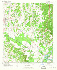
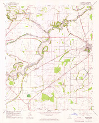 1965 Mooreville1966 Print · USGSThe Mississippi Delta's rail and river systems are on full display in the mid-1960s at the junction of two major lines. Genealogists and historians can trace family landmarks like Moorhead Cem or Swan Lake Ch and locate the old County Farm.
 - 1965 Map of Fulton SE, 1966 Print
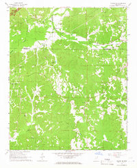
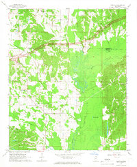
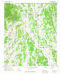
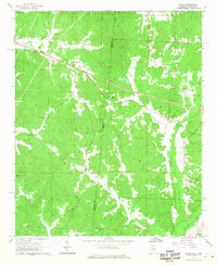
 1965 Fulton SE1966 Print · USGSItawamba County in the mid-sixties is a landscape of winding creek valleys and high ridge lookouts. Researchers can find numerous country churches and cemeteries, from New Temple Ch to Palmetto Cem, and trace the rural roads around Fairview.2 unique versions available
 - 1965 Map of Fulton, 1966 Print
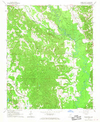
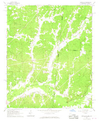
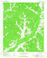
 1965 Fulton1966 Print · USGSItawamba County is documented here in the mid-1960s as the river-and-rail economy of the Tombigbee River valley centered on Fulton. Genealogists and historians can trace numerous rural landmarks, including Warrens Chapel Cem, Indian Mounds, and the Mississippian railroad line.3 unique versions available
 - 1965 Map of Fulton NE, 1966 Print
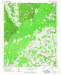
 1965 Fulton NE1966 Print · USGSItawamba County and the surrounding tri-county area are shown in the mid-1960s as the modern parkway system began to reshape the landscape. Genealogists can locate numerous rural landmarks such as Moores Mill, Old Bethel Ch, and the Walker House Cem Ch.
 - 1965 Map of Kirkville, 1966 Print
 1965 Kirkville1966 Print · USGSNortheast Mississippi rural life and early parkway development are captured here in the mid-sixties. Trace family history through Kirkville and Sandy Springs, or find old community sites like Houston Sch and Gilmers Chapel.2 unique versions available
 - 1966 Map of Smithville, 1967 Print
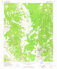
 1966 Smithville1967 Print · USGSMonroe and Itawamba counties appear here in the mid-1960s, a landscape defined by the winding Tombigbee River and historic land lines. Genealogists can locate family landmarks like Dunlap Cem, Bethel Ch, and the distinct paths of the Old Indian Boundary.2 unique versions available
 - 1966 Map of Beans Ferry, 1967 Print
 1966 Beans Ferry1967 Print · USGSThe Tombigbee River corridor in the mid-sixties shows a rural landscape of small settlements and family farms. Genealogists can locate family-named landmarks like Bean Cem and Wiygul Cem or historic community centers such as Beans Ferry and Hopewell Ch.
 - 1966 Map of Turon, 1967 Print
 1966 Turon1967 Print · USGSUpper Monroe and Itawamba counties appear here in the mid-1960s, a rural landscape shaped by ancient treaty lines and small-scale mining. Local researchers can locate dozens of burial sites like Springfield Cem and Jones Cem, or trace the path of the Old Indian Treaty Boundary.2 unique versions available
 - 1966 Map of Nettleton, 1967 Print
 1966 Nettleton1967 Print · USGSNettleton and the Lee-Monroe county line are shown here in the mid-1960s, prior to significant modern development along the river. Genealogists can trace family landmarks like Siloam Sch, Union View Ch, and cemeteries such as Williams Cem and Goodwin Cem.2 unique versions available
 - 1966 Map of Evergreen, 1967 Print
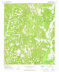
 1966 Evergreen1967 Print · USGSThe rural borderlands of Lee and Itawamba counties appear here in the mid-1960s, showing a landscape defined by small-town life and church communities. Researchers can trace family history at sites like Wesley Chapel Cem or locate former schools and settlements such as Dorsey Sch and Ballardsville.3 unique versions available
 - 1966 Map of Tremont, 1967 Print
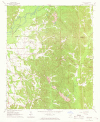
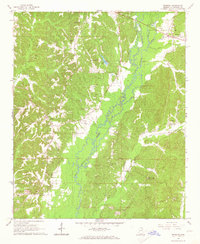 1966 Tremont1967 Print · USGSItawamba County in the mid-1960s reveals a landscape of winding creeks and rural crossroads on the Mississippi-Alabama line. Genealogists and historians can trace family locations near Tremont or find old burial grounds like Clover Ridge Cem and Maxey Cem.2 unique versions available
 - 1967 Map of Shottsville, 1968 Print
 1967 Shottsville1968 Print · USGSThe Mississippi-Alabama borderlands come into focus in the late sixties, showing a landscape defined by small crossroads and family legacies. Researchers can trace the heritage of Shottsville and Bounds Crossroads or locate Spearman Cem and Pearly Gates Ch.
 - 1967 Map of Bexar, 1968 Print
 1967 Bexar1968 Print · USGSThe Alabama and Mississippi state line divides this quiet landscape of the late sixties, where small rural communities are anchored by local schools and churches. Genealogy researchers can find family sites like the Wigginton Cem and Ada Hanna High Sch.
 - 1967 Map of Detroit, 1968 Print
 1967 Detroit1968 Print · USGSDetroit and its surrounding rural communities are captured here in the late sixties along the Alabama-Mississippi state line. Researchers can trace historic land divisions like the Old Indian Treaty Boundary or locate family sites such as Byrd Sch and Riggins Cem.3 unique versions available
End of results
Showing maps 1-14 of 14
Top cities of Itawamba County
Frequently asked questions
- What are the different types of historical maps available for Itawamba County?
- What is the oldest map of Itawamba County?
- Where can I purchase historical maps of Itawamba County for my home or office?
- Where can I download high-res historical maps of Itawamba County?
- Are there historical topographic maps available for Itawamba County?
- Is there historical aerial imagery available for Itawamba County?
- Where are historical maps of Itawamba County sourced from?