1990s Maps of Itawamba County, Mississippi
Explore 8 historic maps of Itawamba County from the 1990s. These maps offer a rare glimpse into what life looked like during the 1990s — showing old roads, neighborhoods, homes, and landmarks that have changed or disappeared over time.
Whether you're researching your family's past, planning a metal detecting trip, or studying how Itawamba County's landscape evolved across the 1990s, these high-resolution maps are a powerful tool for exploring the history of this region.
- Focus on a specific era: All maps on this page are from the 1990s, giving you a focused view of this time period.
- See what’s changed: Compare century-old streets, trails, and buildings to today's modern landscape using overlays and satellite layers.
- Research with precision: Use these maps for genealogy, historical research, land use analysis, or educational projects.
- View, download, or print: Maps are fully viewable online in high resolution, and can be downloaded or printed for your own records.
Start exploring Itawamba County's history through authentic maps from the 1990s. This is your window into the past.
Itawamba County, MS maps
(8)- 1992 Map of Nettleton, 1995 Print
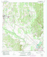 1992 Nettleton1995 Print · USGSNettleton and the surrounding Lee and Monroe county borderlands are shown here in the early nineties, during a period of industrial change. Genealogists can trace family names through numerous rural burial sites like Providence Cem and Goodwin Cem or locate old landmarks such as Jones Chapel Ch.
 - 1992 Map of Smithville, 1995 Print
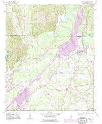 1992 Smithville1995 Print · USGSMonroe and Itawamba counties appear here during the 1990s as the regional landscape was reshaped by the massive Tennessee-Tombigbee Waterway. Genealogists and historians can trace family sites at New Chapel Cem, Dunlap Cem, and Pooles Chapel near the community of Smithville.
 - 1992 Map of Beans Ferry, 1995 Print
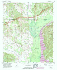
 1992 Beans Ferry1995 Print · USGSItawamba County is documented here in the early nineties, showing the intersection of the massive TENNESSEE-TOMBIGBEE WATERWAY and the older river path. Genealogists can trace family landmarks like Bean Cem, Booth Cem, and the settlement at Beans Ferry.
 - 1992 Map of Tremont, 1995 Print
 1992 Tremont1995 Print · USGSEastern Itawamba County is documented here in the early nineties, showing a landscape defined by Bull Mountain Creek and the town of Tremont. Genealogists can locate family landmarks like Maxey Cem and old settlements such as Tilden and New Salem.
 - 1992 Map of Fulton, 1995 Print
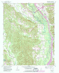
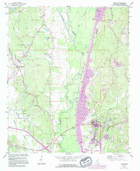 1992 Fulton1995 Print · USGSItawamba County’s river landscape is shown here during the late twentieth-century expansion of the Tennessee-Tombigbee system. Genealogists can trace family landmarks like Files Cem and Stephens Ch alongside the growing campus of Itawamba Community College.
 - 1992 Map of Fulton NE, 1995 Print
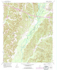
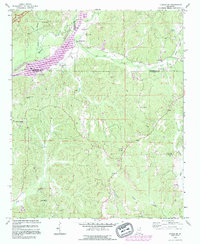 1992 Fulton NE1995 Print · USGSItawamba and Tishomingo counties are shown in the early nineties, just as the Tennessee-Tombigbee Waterway and wildlife management areas were reshaping the land. Genealogists can trace family landmarks like Allens Chapel Cem, Sandy Springs, and Moores Mill.
 - 1992 Map of Kirkville, 1995 Print
 1992 Kirkville1995 Print · USGSThe Itawamba and Prentiss county line comes alive in the 1990s as the massive Tennessee-Tombigbee Waterway reshapes the landscape. Genealogists and local historians can trace the locations of the Ozark Methodist Ch, the Warren Cem, and the ancient Pharr Indian Mounds.
 - 1992 Map of Ratliff, 1995 Print
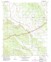 1992 Ratliff1995 Print · USGSNortheast Mississippi’s hill country is captured here in the early 1990s as the Natchez Trace Parkway cuts through the rural landscape. Researchers can trace family sites and local landmarks at Pratts, Chapelville, and Oak Grove Cem.
End of results
Showing maps 1-8 of 8
Top cities of Itawamba County
Frequently asked questions
- What are the different types of historical maps available for Itawamba County?
- What is the oldest map of Itawamba County?
- Where can I purchase historical maps of Itawamba County for my home or office?
- Where can I download high-res historical maps of Itawamba County?
- Are there historical topographic maps available for Itawamba County?
- Is there historical aerial imagery available for Itawamba County?
- Where are historical maps of Itawamba County sourced from?