1990s Maps of Panola County, Mississippi
Explore 3 historic maps of Panola County from the 1990s. These maps offer a rare glimpse into what life looked like during the 1990s — showing old roads, neighborhoods, homes, and landmarks that have changed or disappeared over time.
Whether you're researching your family's past, planning a metal detecting trip, or studying how Panola County's landscape evolved across the 1990s, these high-resolution maps are a powerful tool for exploring the history of this region.
- Focus on a specific era: All maps on this page are from the 1990s, giving you a focused view of this time period.
- See what’s changed: Compare century-old streets, trails, and buildings to today's modern landscape using overlays and satellite layers.
- Research with precision: Use these maps for genealogy, historical research, land use analysis, or educational projects.
- View, download, or print: Maps are fully viewable online in high resolution, and can be downloaded or printed for your own records.
Start exploring Panola County's history through authentic maps from the 1990s. This is your window into the past.
Panola County, MS maps
(3)- 1990 Map of Helena, 1991 Print
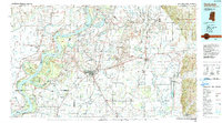
 1990 Helena1991 Print · USGSThe Arkansas and Mississippi delta regions meet here in the 1990s, where the great river's oxbows and islands define the state line. Genealogists and historians can trace the rail networks of the Illinois Central Gulf RR and local settlements like Palestine, Marvell, and La Grange.
 - 1990 Map of Oxford, 1991 Print
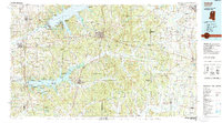 1990 Oxford1991 Print · USGSNorth Mississippi at the start of the nineties centers on the university town of Oxford and the large reservoirs of the Tallahatchie River valley. Researchers can trace the Illinois Central Gulf RR through towns like Water Valley and locate landmarks such as College Hill Sta.
 - 1990 Map of Clarksdale, 1991 Print
 1990 Clarksdale1991 Print · USGSThe Mississippi Delta in the 1990s remained a landscape of river-driven commerce and small-town resilience. Researchers can trace the path of the Illinois Central Railroad through settlements like Clarksdale, Friars Point, and Alligator.
End of results
Showing maps 1-3 of 3
Top cities of Panola County
- Batesville historical maps
- Sardis historical maps
- Como historical maps
- Courtland historical maps
- Pope historical maps
Frequently asked questions
- What are the different types of historical maps available for Panola County?
- What is the oldest map of Panola County?
- Where can I purchase historical maps of Panola County for my home or office?
- Where can I download high-res historical maps of Panola County?
- Are there historical topographic maps available for Panola County?
- Is there historical aerial imagery available for Panola County?
- Where are historical maps of Panola County sourced from?