1940s Maps of Panola County, Mississippi
Explore 5 historic maps of Panola County from the 1940s. These maps offer a rare glimpse into what life looked like during the 1940s — showing old roads, neighborhoods, homes, and landmarks that have changed or disappeared over time.
Whether you're researching your family's past, planning a metal detecting trip, or studying how Panola County's landscape evolved across the 1940s, these high-resolution maps are a powerful tool for exploring the history of this region.
- Focus on a specific era: All maps on this page are from the 1940s, giving you a focused view of this time period.
- See what’s changed: Compare century-old streets, trails, and buildings to today's modern landscape using overlays and satellite layers.
- Research with precision: Use these maps for genealogy, historical research, land use analysis, or educational projects.
- View, download, or print: Maps are fully viewable online in high resolution, and can be downloaded or printed for your own records.
Start exploring Panola County's history through authentic maps from the 1940s. This is your window into the past.
Panola County, MS maps
(5)- 1940 Map of Oxford, 1956 Print
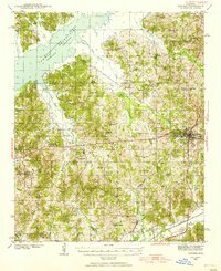 1940 Oxford1956 Print · USGSLafayette County was undergoing a major landscape shift in the 1940s as the Sardis Reservoir took shape northwest of Oxford. Researchers can trace the early layout of the University of Mississippi and dozens of rural landmarks like Pearly Gate Ch and College Hill Sta.2 unique versions available
 - 1943 Map of Oxford
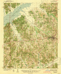 1943 Oxford1943 Print · USGSLafayette County during the early years of the Second World War shows the transformation of the Tallahatchie valley as the Sardis Reservoir begins to dominate the north. Researchers can trace the rural infrastructure of the era through sites like Spring Hill Sch & Ch, the Illinois Central tracks, and the University of Mississippi.2 unique versions available
 - 1944 Map of Senatobia, 1946 Print
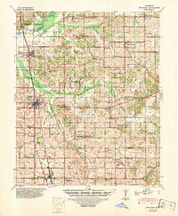 1944 Senatobia1946 Print · USGSNorthwest Mississippi at the end of the war reveals a landscape of rural school-churches and new reservoirs. Genealogists can trace family roots at the Wright Fam Cem, Lashures Sch & Cem, or the Bethlehem African Ch near the Illinois Central line.3 unique versions available
 - 1944 Map of Tyro, 1964 Print
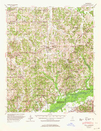 1944 Tyro1964 Print · USGSMississippi's hill country met a changing river landscape in the mid-1940s as the Sardis Reservoir took shape. Genealogists can trace hundreds of family landmarks, from Harmontown to local institutions like St Josephs Ch & Sch and Lammey Fam Cem.
 - 1948 Map of Helena
 1948 Helena1948 Print · USGSEastern Arkansas and the Mississippi Delta are captured here just after the war, showing a landscape defined by its great rivers and rail lines. Genealogists can trace family locations near Bemis Plantation, Helena, and smaller rail stops like Wheatley and Moro.
End of results
Showing maps 1-5 of 5
Top cities of Panola County
- Batesville historical maps
- Sardis historical maps
- Como historical maps
- Courtland historical maps
- Pope historical maps
Frequently asked questions
- What are the different types of historical maps available for Panola County?
- What is the oldest map of Panola County?
- Where can I purchase historical maps of Panola County for my home or office?
- Where can I download high-res historical maps of Panola County?
- Are there historical topographic maps available for Panola County?
- Is there historical aerial imagery available for Panola County?
- Where are historical maps of Panola County sourced from?